Forward scan sonar sensor for trawlers place where the keel

The friendliest place on the web for anyone who enjoys boating.
If you have answers, please help by responding to the unanswered posts.
Joined
Sep 10, 2015
Messages
1,109
Location
Finland
Vessel Make
Nordic Tug 37
:confused:Forward scan sonar sensor for trawlers place where the keel.

if you installed one, where is located?

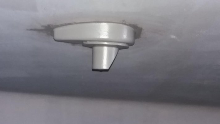
I was thinking to acquire such, but I wonder the location of the sensor, a long keel damage to the scan angle in the lateral direction and the bow is a deep v. how have you solved the problem? If you have a photograph or free-hand drawing of principle, I would be grateful.

If you experience any of the forward scan sonar device would like to hear the good, the bad and the ugly story.

The idea may need forward scan sonar it at a slow speed to avoid driving in stone, as i drive in a foreign place here in rocky waters.
 
We have an Interphase forward looking sonar. No bad, all good. With the deep forefoot of our Defever though, it can't see fully to the Port side. The transducer is located about 7 feet back from the bow, and when operating in the mode where the beam scans from the surface to the bottom it easily shows the water depth out in front. It's a great tool.......
 
I have been considering using a small waterproof video camera, just under the surface at the bow, for the same purpose.
With a screen at the helm position, it could prove invaluable for conning tricky passages at low speed.
 
I have been considering using a small waterproof video camera, just under the surface at the bow, for the same purpose.With a screen at the helm position, it could prove invaluable for conning tricky passages at low speed.

I have experience doing just that on small cruise ships. The video was fed to all the TV's on the ship. My experience is that water clarity is a huge variable in how usefull the camera is. Since the cameras were installed in housings welded to the boat, they were not removable for cleaning and required someone in a small boat to clean the lens regularly, along with polishing at haul out time. When the water was clear and speeds low, all types of creatures came into view, including porpose's playing in the bow wake. As a navigation tool, I"m unsure how usefull it would be with a limited range of view but in really clear water it might be fine if you could judge distance accurately. A forward looking sonar would be far superior, but much more expensive.
 
Each sounder has their own instructions. Also depends on one or two transmitters. However, what seems universal is to mount them forward of all other thru hulls and as far forward as you can and they remain level when you're running. So typically that may be anywhere from 20% to 40% back of the bow.
 
Im surprised that more folks don't have some form of forward facing sonar. That would be high on my list of things to have, especially with Garmin and Simrad's low cost units.
 
Im surprised that more folks don't have some form of forward facing sonar. That would be high on my list of things to have, especially with Garmin and Simrad's low cost units.

I will say this too. We've used other forward facing sonar for 3-4 years and we were very pleasantly surprised by the Garmin. It fulfilled our needs on the loop very well. It's something that only benefits you on rare occasions but when it does, it's worth it's weight in gold.
 
I will say this too. We've used other forward facing sonar for 3-4 years and we were very pleasantly surprised by the Garmin. It fulfilled our needs on the loop very well. It's something that only benefits you on rare occasions but when it does, it's worth it's weight in gold.

Band,

Assume you have the PS51-TH? Where did you install it on the boat? As for performance, any major limitations? And how fast can you go and still get good readings? Bow rise an issue?

Did you consider the Simrad unit also?

Thanks! It's been hard to find folks that have these units and I love to hear from the end users.

They don't see very far forward. So they are only useful at slow speeds.
 
I have been considering using a small waterproof video camera, just under the surface at the bow, for the same purpose.
With a screen at the helm position, it could prove invaluable for conning tricky passages at low speed.

Personally I can't see where a camera would be of any use unless the water was exceptionally clear on a bright day.

Even then I'm not sure how far forward you would clearly see.
 
They don't see very far forward. So they are only useful at slow speeds.

Agreed, but would like to know the speed range. But, in waters that are unknown, I'd agree that one would want to be slow enough to avoid bumping something.
 
Band,

Assume you have the PS51-TH? Where did you install it on the boat? As for performance, any major limitations? And how fast can you go and still get good readings? Bow rise an issue?

Did you consider the Simrad unit also?

Thanks! It's been hard to find folks that have these units and I love to hear from the end users.

No, we didn't consider the Simrad as we purchased the boat with complete Garmin package.

It's really not for use at anything but slow speeds. We're not going to run30 knots and try to read a Garmin forward sonar. It was factory installed but to give perspective on where it is, it is about the entrance to the bow cabin. The range of the Garmin is about 300'. By comparison, Far Sounder has range up to 1/2 mile. Echopilot is about 600'. All are impacted by depth too. For instance, Simrad's range is 5 to 8 times depth. So, in 10' of water your forward range would only be 50 to 80 feet.

On the Garmin our use has been to slow down and carefully check areas we questioned, to get a feel for what is there. Helpful at marinas when you're not certain of the depth where you've been told to tie, or at an anchorage that has borderline depth and a very narrow entrance. You get a warning from someone that the channel ahead is far to the starboard side, has really shifted and is very narrow but if you go outside the channel it drops rapidly. Good time to go very slow and see exactly where the channel is.
 
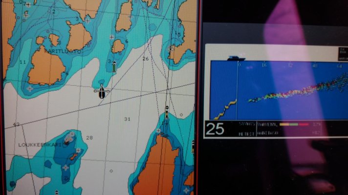
I ordered today Echopilot foward sonar platinum, now just wait for it to arrive. it is really difficult to think of the sensor position, it would be the best because Nordig tug hull shape tricky mind foward sonar.


EchoPilot Forward Sonar - EchoPilot Platinum Engine


I will use my monitor Raymarin C120 plotter


all the experiences from the sensor welcome, and thank you for responding to..


cache_2692357.jpg
 
Last edited:
Forward-looking sonar: 5 units tested - Practical Boat Owner


For those interested in a small test look forward sonars, if anyone knows of other tests put the link, thank you.

Very suspicious tests. Three Echopilots vs. a B&G and a Garmin? And the person quoted was the Echopilot employee? Sounds way too much like Echopilot running the show.

That said, Echopilot does have more range than Garmin and does make some superior scanners. The FLS 3D is even a better Echopilot but at six times the price. Then at ten times the price of an Echopilot, there's Farsounder with far more range.

So, I do agree with the conclusions of the tests, just still think they were a bit biased.

The issue I see with sonars is that those like Garmin, Furuno, and Simrad, all really evolved from fishing needs. The Echopilot was developed for boating. From the outset, it's development was aimed toward depth and bottoms, not detecting fish and toward seeing further forward. It reflects that and, therefore, in my opinion, is superior to the others.

On the other hand, Far Sounder was developed for commercial users and passenger vessels with a few megayachts thrown in. It was also developed for security purposes and they even have a contract with Homeland Security. They weren't facing the price constraints of the other. So, their product is definitely superior but not a product for most recreational vessels.

I've used all three Farsounder, Echopilot, and Garmin. Far Sounder best and by far most expensive. Echopilot 3D second but several times the price of other Echopilots. Other Echopilot models still probably slightly ahead of Garmin, Furuno, and Simrad. However, we find Garmin to do an excellent job of what we need it for and on a boat with all other Garmin equipment we're very pleased with the choice and the integration.
 
of course, all of the rewievs, ads, and even if the tests TF forum writings must be able to read the interpretation.


This test does not affected by their selection for the machine to. the most important influence in my choise were collected from various forums Information, as well as price.


I have all the navigation equipment Raymarin and only Echopilot paltinium support the old system. If I had purchased a Garmin, I would have to buy a new addition to the sensor, a new plotter, a new electronic map, a new radar, new autopilot system, the new anemometer etc ... quite expensive for me to swear in the name of Garmin. If I was buying a whole new system, Garmin could have been when the winner for me


I think the most interesting sonar can be found Huminbird 360 °, unfortunately, they do not suitable sensors on my boat. I is very cool see under water 360° live foto pictures.


I have been quite the same character which the device is, I only hope it will help me to prevent the grounding. Just a few knot speed, the three call waiting and unpleasant lesions deep in the fiber. We have a pretty cloudy water here and more rocks as you can see in big nightmare ...


Last edited:
Now it is installed and operational. The sensor is 70 cm from the keel to the side. the bow of the sensor 5 meters. everything seems to work well in a logical manner. Only been in use for one weekend trip, and seems to make its promises.

20170409_140021.jpg


echopilot my Raymarine display

20170403_174709.jpg

20170403_174547.jpg

20170409_110521.jpg

20170329_123953.jpg
 
Last edited:
Very interesting and thanks for sharing all the details, shows the sonar follows along the chart plotter just right!
 
Small update to topic. Video how Echopilot works ... depth and distance in meters under the keel and sonar sensor, echopilot in automatic mode, ie change distance when depth changes. Future depth on right side, future depth approximately points in the center of altitude and closer to the boat. Yellow line is a history of reality ...At the beginning of the video "disorder" a possible fish flock.

Picture is link vimeo
https://vimeo.com/240828701

NBs
 
Last edited:
How fast was boat going?

Hi,

about 7-7,5 knots. Chart is zoom 1/2 nm range


The device still working and looks great with my max speed at about 18kn, the reaction time of course shortens. I drive a lot out of the fairways. Here are turbid waters, lots of rocks and shallows not marked on a map or a stone sign on the map is 63 meters in real life.

Nbs
 
Last edited:
NBS,

Thx much for the report. I've been trying to follow the progress of these forward sonar units for a bit, and am ready to get one.

I believe I'm going with the Simrad, because I'm installing a Simrad package and feel it will fit well.

I came very close to the Echo Pilot, and still might change my mind.
 
Small update to topic. Video how Echopilot works ... depth and distance in meters under the keel and sonar sensor, echopilot in automatic mode, ie change distance when depth changes. Future depth on right side, future depth approximately points in the center of altitude and closer to the boat. Yellow line is a history of reality ...At the beginning of the video "disorder" a possible fish flock.

Picture is link vimeo
https://vimeo.com/240828701

NBs

How does one enterpret this? What does it look like with a tree branch or similar object ahead? What is it's effective range?
 
How does one enterpret this? What does it look like with a tree branch or similar object ahead? What is it's effective range?[/QUOT

I can not say about the tree, but I believe it is sending back the message, because clay and sand signal or show a stone even if covered with a lot of plants to the sonair.


You can test this with your own sonar, moving some wood under your sensor and believing that the probe detects it.

Here is my calculation of how the probe sector grows as the distance increases.

Forward distanse from the sensor and sector Width
5m / 1,3m
10m /2,6m
15m / 4m
20m / 5,2m
30m / 8m
40m / 11m
50m / 13m
100m / 26m
150m / 39m
200m / 52m


Examples. Forward the distance to 100 meters of the beam width there 26 meters.

In addition, sonair works and looks effective 1: 5-6 in depth: distance. For example, a 5 meter depth probe can look about 30 meter ahead in real time, which is 8 meter wide from the sea bottom to the surface.

In practice it is good that the sector is quite narrow, because it is easier to find a route between stones. If the beam is much wider it would give improper information about the route next to it. 3D FLS is, of course, different, but the price is also x 10.
 
Last edited:
NBS,

Thx much for the report. I've been trying to follow the progress of these forward sonar units for a bit, and am ready to get one.

I believe I'm going with the Simrad, because I'm installing a Simrad package and feel it will fit well.

I came very close to the Echo Pilot, and still might change my mind.

Hi,

I do not have the experience of smirad, but I think it is also ok. The most important thing is to find the right place for the sensor and that the sensor can be in the straight line and sideways !!!


If the sensor is in a place where air bubbles and swirls occur, for example, any other sensor interferes with the sonar sensor and can not function well, this is important to remember.

One more video will be echopilot working in the next week. (My Vimeo account limit is full this week)
NBs
 
Last edited:
And update video part 2, you can see time 1.23, How much map and reality differ, so there is a lot of security in FLS, If the draft had been critical.
Speed 8,2 knots, numers meters, chart is 1/2 nm zoom.

https://vimeo.com/241873955


NBs
 
Last edited:
Have you been able to test it against small objects like a piling or such?

There is a ton of semi/submerged oil rigs in galveston bay. the fls would really be handy here.
 
Have you been able to test it against small objects like a piling or such?

There is a ton of semi/submerged oil rigs in galveston bay. the fls would really be handy here.

Speed, or lack thereof, is the key to gathering useful information in that situation. You just can't outdrive your scan so need to be slow enough it can record the data, you can see and interpret it and then you can react. We've found it most useful in areas where we knew there were potential issues. One place had a submerged piling in a marina, but they'd rearranged the docks completely. We were easily able to locate the piling. Another situation in an anchorage with only a small amount of deep area and otherwise very shallow. We were quickly able to identify where the drop off was. Going up into a cove with an ok channel but very shallow to both sides and no markers in that area. Once in an area that had recently had a storm and had high water with a lot of debris. We went slow and kept our attention on it. There was one limb underwater that we may well not have detected and might have hit. We've found only a few times that we needed the sonar, but those times, it was worth the price.
 

Latest posts

Back
Top Bottom