Victoria BC to Portland,OR

The friendliest place on the web for anyone who enjoys boating.
If you have answers, please help by responding to the unanswered posts.

bshillam

Guru
Joined
May 18, 2013
Messages
801
Location
USA
Vessel Name
Our Heaven
Vessel Make
1997 4800 Navigator
Starting to plan to move the boat South. Looking really rough right now but I won't be able to move it until after Jan 7th. I'll make sure to keep everyone abreast. I have the time to wait until the weather allows me to move it safely!
 
This is exciting! If I can be of assistance on the Olympic Peninsula, please reach out. Will send PM.
 
Do you plan to run 24x7 or only during daylight hours? I bet you'll appreciate having the speed of your 48 in your back pocket if you need to run for cover.
 
Neah Bay is a nice little place to tuck into before you head down the coast. It's also a great place to fuel up because they are a reservation and don't pay all of WA's stinkin' taxes.


When you get to Tatoosh Island there's a nice little shortcut on the south side of the island. It goes between the island and that first rock and it's about 400' across. We found out about it from a retired USCG shipper who took his 190' cutter through there instead of going out around the island. Saves a lot of time and fuel.
 
Last edited:
We plan only to run during daylight hours. I have learned when possible enjoy the journey!
 
Neah Bay is a nice little place to tuck into before you head down the coast. It's also a great place to fuel up because they are a reservation and don't pay all of WA's stinkin' taxes.


When you get to Tatoosh Island there's a nice little shortcut on the south side of the island. It goes between the island and that first rock and it's about 400' across. We found out about it from a retired USCG shipper who took his 190' cutter through there instead of going out around the island. Saves a lot of time and fuel.

In my opinion the risk / reward ratio of using that short cut is way out of balance. To use that shortcut a boater has to pass between the very unfriendly shore of Tatoosh Island and Jones Rock which as the chart notes is awash at 1/2 tide. Running aground in that area is not a trivial matter. Currents can be running hard in there, any wind at all opposing the currents kicks it up quite a bit.

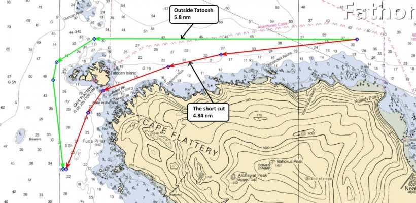
Regarding time and fuel saved, when looking at the charts if I use an outbound go / no-go decision point just west of Neah Bay to a point where the two routes converge again south of Tatoosh I get the following:
5.8 nm outside north of Tatoosh
4.84 nm inside south of Tatoosh
0.96 nm distance saved by using the short cut

At a trawlerish speed of 8 kts and a burn rate of 3 GPH that is a time savings of 7.2 minutes and a fuel savings of 0.36 gal.
 

Attachments

  • Tatoosh short cut.jpg
    Tatoosh short cut.jpg
    140.6 KB · Views: 195
bshillam

This question is not unexpected given your new boat purchase timing. It would seem you have picked about the worst time to want to do this journey. Dark short days, brief weather windows and uncomfortable latent seas due the usual PNW offshore slop of winter.

Add to this a new to you boat that could have a lurking gothca or two. You may want to consider cruising the vessel for about 6 weeks in the Gulf or San Juan Islands. Or do the same out of Tacoma which is a short drive from Portland. that way you can test out the vessel, make the necessary upgrades and or repairs and be ready for normally better conditions in late February.
 
I am surprised that your insurance company is letting you do this trip without a Licensed Captain on board at this time a year.
 
What is the rush? Why not enjoy cruising in the protected waters of British Columbia until later in the season?
 
All very good questions coming up.

I will have an unlimited tonnage Captain aboard. I will not be risking the trip outlook has to look good for more than one day. I’ll get the boat brought up to speed mechanically and then make a decision. Mooring it in Olympia or close by might be an option. Lots of cruising to enjoy in South Puget!
 
I do the Neah Bay to the Columbia River Bar in 12 hours. I don't do the short cut. If you have the speed, then look at weather and then timing of the bar. The weather this time of year is iffy at best. Plan your weather from B.C. to Neah Bay to Astoria. Crab pots are also a concern. Keep a watch for them.
 
We do have speed and will be planning Neah to Astoria.
 
I am surprised that your insurance company is letting you do this trip without a Licensed Captain on board at this time a year.

Indeed.

I (as a licensed skipper) have turned down 2 delivery jobs (PDX to Seattle, and reverse) that wanted to go last week and in early January. It's more of a crapshoot during this time of the year- leaving Puget Sound is not too bad, but the coastal run can be either huge head seas with a south wind, or a washing machine following sea. Both suck.

Worst, the Columbia Bar crossing can be hell this time of year.

My advise- don't be in a rush to die.
 
We do have speed and will be planning Neah to Astoria.


If you get caught out in bad wx don't even think of going into Willapa Bay. It's a very dangerous entrance due to the channel shifting with each storm. Local knowledge is important. La Push maybe, depends upon wind and sea direction. Grays Harbor is a decent hole if you need to stop before making the Columbia River.

How much experience does your unlimited master have with small boats running coastal and crossing hazardous bars? I'm not putting him/her down, very impressive accomplishment achieving that license. But its a completely different set of skills than a big ship at sea.
 
Another thought- what is the condition of the fuel tanks and fuel? Too often, the waters offshore stir up junk in the tank(s) that have a nasty habit of clogging the fuel filters at exactly the wrong moment- and it's zero fun changing Racors in a sloppy sea, then priming the engine and getting back underway.

Just more food for thought....
 
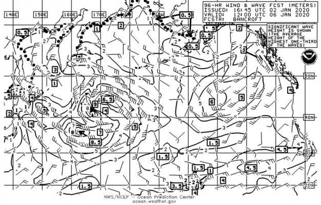
I just pulled GRIB - showing between 4m - 7m @ 12-secs with winds pretty consistent in the mid-upper 20's with gusts to 40 kts through Jan 7th. NWS 96hr Wind/Wave forecast for Jan 6 confirm 4-meters. Could be a wait before turning the corner.

Agree on not cutting between Tatoosh and the Cape. It's workable in calm/slack tide with decent visibility. The "Shortcut" moniker comes from not going all the way out to #2 Red buoy which is just outside the screen shot shown.
PJBM98.jpg
 
I've done this run north of 20 times in a Navigator 53 as well as other boats. Neah Bay to the Columbia River Bar is about 140NM. So leave in the morning and you will have daylight the entire way - say 11-12 hours in a Nav 48. Neah Bay is an Indian reservation (or whatever the current politically correct term is) and so fuel is very cheap as they are immune from federal fuel tax.

I run the cut thru Tatoosh every time but it is hairy the first few times. You gotta stay very close - like 50' or less - to the giant rock island of Tatoosh, which isn't a comfortable feeling. Best to follow the fisherman out and there are a lot of them leaving in the morning.

The key to this run is getting to the Columbia River Bar at the right time. Whatever you do, avoid being on the Bar on the ebb. Do your homework on the Bar and you should be fine. Use a tool like Navionics that has an ETA calculator so you time it right. Have enough fuel so that if the Bar is closed you can circle for a while til it opens.

One last thought. I have never run the ocean in the winter and probably would do everything in my power to avoid it. We tried once in early February and were turned around with 40 knot winds inside Neah Bay. The Oregon/Washington coast is just plain nasty in the winter.

Just my $0.02 worth.

Pete
 
I spent a lot of time commercial fishing off the North west coast. You get a better ride in deeper water. When running the coast I usually stay 25 miles out and try to be in 100 fathoms or more. As water shoals, swells get steeper. Headlands are usually where you'll find the biggest waves. I find traveling out 25 miles, even just going from Neah Bay to Astoria, worthwhile. You also miss the crab pot lines until you angle in to Astoria. Otherwise you dodge them all the way.

Most of the year the swells come from the W to NW, but in the winter, lows passing thru tend to beat down the swell. LaPush appears to be a nice stop, but is a difficult entrance in weather from the south. It's usually closed by heavy S to SW swells. Once you're out in the ocean between Neah Bay and Astoria there's no good spots to dodge the weather. Wait it out in Neah Bay. They have a good store close to the marina.

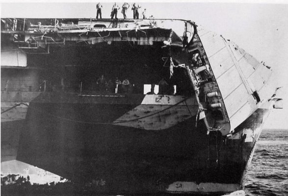
I made the trip from Seattle to San Diego in the winter on a destroyer. Off the Washington coast we were down to 8 knots to keep from causing damage. 100 miles outside of us, a carrier was dipping the flight deck into the swells.
 

Attachments

  • carrier flight deck.jpg
    carrier flight deck.jpg
    103.4 KB · Views: 178
I just pulled GRIB - showing between 4m - 7m @ 12-secs with winds pretty consistent in the mid-upper 20's with gusts to 40 kts through Jan 7th. NWS 96hr Wind/Wave forecast for Jan 6 confirm 4-meters. Could be a wait before turning the corner.

Agree on not cutting between Tatoosh and the Cape. It's workable in calm/slack tide with decent visibility. The "Shortcut" moniker comes from not going all the way out to #2 Red buoy which is just outside the screen shot shown.
View attachment 97983


Update to my previous post #6. Taking the short cut vs going north of red #2

8.4 nm north of red #2
4.84 nm through the short cut
At 8 kts and 3 GPH you'd save 26.7 min and 1.335 gal.

I've run the short cut in daylight, favorable tides and calm water. But I won't run it at any other times.

Regarding winter wx off the Wash & Oregon coasts. Once in late Oct I laid Neah Bay for 5 days. When the prediction looked good we departed. But the next storm came in faster and stronger than predicted. The Grays Hbr buoy reported mean significant wave height of 24 ft at the time we passed. That means 1/3 of the seas were bigger than 24 ft. We were nearly stood on ends by a huge one and that was in 65 ft and 87 tons of steel. That boat made 8.5 kts good in fair wx, that time we were down to 4.5 kts. My advice is don't run the Wash & Oregon coasts from mid Oct till end of March unless you absolutely have to.

If you decide to go follow Lepke's advice and stay out 25 nm at about the 100 fathom mark. But seriously, don't go.
 
Re Pau Hana and fuel - My thoughts exactly. Not the best time of year to head south - but if the OP has time to sync with the weather vs a schedule and has the bank balance to run at planing speed then why not. Maybe investing in a weather planning service for the cruising window would be worthwhile. Isn’t insurance coverage for this trip dicey to get at this time of year?
 
Last edited:
Re Pau Hana and fuel - My thoughts exactly. Not the best time of year to head south - but if the OP has time to sync with the weather vs a schedule and has the bank balance to run at planing speed then why not. Maybe investing in a weather planning service for the cruising window would be worthwhile. Isn’t insurance coverage for this trip dicey to get at this time of year?

In December 1982, I was crew on the USS Constellation- we did a homeport change to Bremerton. We got the crap kicked out of us along the WA coast- major damage, and memories galore. I’ll always err on the side of caution.

If the OP has had his tanks cleaned and fuel polished, all the better- Murphy will take any opportunity to make life miserable.

Insurance- it depends on the policy language. Most policies with Puget Sound navigation define the offshore limits as “within 25 min of Cape Flattery”. Others have navigation that is much more broad based. In any case, there is a duty/responsibility of the named insured to not put the vessel (and crew) in harms way deliberately.
 
"When you get to Tatoosh Island there's a nice little shortcut on the south side of the island. It goes between the island and that first rock and it's about 400' across. We found out about it from a retired USCG shipper who took his 190' cutter through there instead of going out around the island. Saves a lot of time and fuel."


I've done this short cut twice now. Both in settled weather in the early AM leaving Neah Bay. 1st time was fine, easy and slack. 2nd time I got beat up even in settled weather because of the current that rips through there and turns it into a confused mess. I actually lost time as I got slowed to under 4 knots fer awhile.

I'll go around next time. The Admiral will be happy. -er. -ish.
 
This is not the normal time to go south. I recommend waiting.
This is an unforgiving patch of the Pacific Ocean.
The seas this time of year can get real snotty.
Weather can change very quickly.
Normally people with good local knowledge wait till about MAY or so to do that trip. It is a lea shore the whole way.
Many Harbor entrance Bar's close in bad weather & you can't get out of it to rest. Do you have to go now ? "Get there itis" has killed a lot of people.
Listen to all the other posters from the area. Don't be in a hurry.
Columbia Bar crossing can be very bad & dangerous this time of year.
Your boat is untested & fuel tank internal contamination is unknown.
With My Kadey Krogen 42 I would still wait till May.
Not saying it is impossible, just not recommended.
Watch for a good weather window.
Luckily it is not a long run - Maybe 140 miles or so.
Good Luck.

Alfa Mike
 
Last edited:
Starting to plan to move the boat South. Looking really rough right now but I won't be able to move it until after Jan 7th. I'll make sure to keep everyone abreast. I have the time to wait until the weather allows me to move it safely!

Aside from the weather delays, be aware of the WA tax issues. Likely best to clear customs into US and then be prepared to go back into Canada if WA tax timelines become iffy.

Does the vessel have diesel heat?
 
With a licensed captain on board you will be pressed for time, as you will be paying him by the day. That means you will tend to push weather windows to the very uncomfortable range, vs days you would choose to travel yourself.

If it were me, and I’ve bought two boats that were brand new to me in the winter and took them 1500 miles north to Alaska in the spring. I’d wait for a decent time of the year and then do the trip myself. Mid April is when we departed for Alaska, but that might vary a bit since you are heading south.

You have a pretty good cruising ground where the boat is right now to play and yes learn your boat. I would take advantage of that. You have 90 days from closing to move your boat out of Washington, or to file for another 90 days sales tax exemption. Use those days! That gives you until summer to move your boat.
 
Last edited:
All agreed, great advice. I'll be watching the weather window very closely. I won't put myself, my crew, or the boat in any danger. If I have to waiting until March won't be a big deal, I wouldn't use the boat much in that time frame. I'll move it to the South Sound and take a few trips in it over the weekend getting to know her. She's been used, tanks are in good shape as well as fuel all clean and clear. All mechanical will be addressed prior to leaving. I might relocate the boat to Port Angeles or say Olympia much closer to Portland.
 
Re home porting in WA. Just be aware, as an out of state resident, 45 days after purchase you are liable for 9% sales/use tax.
 
Re home porting in WA. Just be aware, as an out of state resident, 45 days after purchase you are liable for 9% sales/use tax.

Staying in Sydney area for awhile is a good workaround to the WA tax thieves, there are several very good boat repair places once you have your to do list worked up.
 
Re home porting in WA. Just be aware, as an out of state resident, 45 days after purchase you are liable for 9% sales/use tax.

I was aware of that but do know there is a work around through Washington. I'll be looking into very closely, 9% would be a very expensive vacation.
 

Latest posts

Back
Top Bottom