Does this navigation software exist? What do you use?

The friendliest place on the web for anyone who enjoys boating.
If you have answers, please help by responding to the unanswered posts.

Adopo

Guru
Joined
Aug 27, 2018
Messages
699
Location
USA
Vessel Name
Calypso
Vessel Make
1981 Fairchild Scout
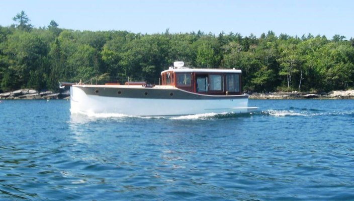
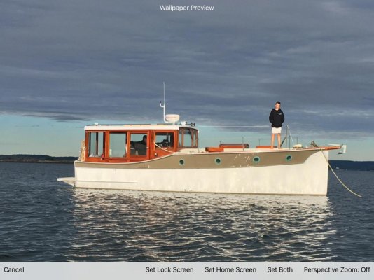
So, I just purchased a very cool little pocket trawler. Although it is the same model I just sold it is quite an upgrade-Fairchild Scout 30.

The cruise from Brooklin Boatyard to Hinckley at Southwest Harbor was so nice, that I am thinking of driving it down to Charleston. That got me thinking.

Is there a program or software out there that helps you navigate that offers the following:

1-Works sort of like google maps or any other map program that will chart distance using known navigation routes, kind of like roads?

2-That will provide potential marinas to dock at based on a preset input, say you want to travel 60 to 75 miles per day?

This option would allow you to drill down deeper, for instance utilizing a star rating system for the higher ranked marinas, accommodations, and restaurants.

Fuel prices and other fees would also be provided real time in addition to known hazards, tide charts, and other notes.

3-Overlay with weather charts and future forecast

In other words, anything you might need to make the trip, and planning easy. We are pilots, so I am looking at this like Skyvector, Foreflight, or some other program but even more. I am sure this must be out there, but pointing me in the right direction will be helpful.
 

Attachments

  • 6256212_20170602053441072_1_XLARGE.jpg
    6256212_20170602053441072_1_XLARGE.jpg
    124.1 KB · Views: 123
  • 6256212_20170602053442722_1_XLARGE.jpg
    6256212_20170602053442722_1_XLARGE.jpg
    92 KB · Views: 109
  • 20190925_152326.jpg
    20190925_152326.jpg
    135.6 KB · Views: 128
  • 20190925_154332.jpg
    20190925_154332.jpg
    137.1 KB · Views: 131
  • unnamed-4.jpg
    unnamed-4.jpg
    116 KB · Views: 125
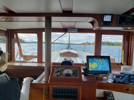
Noticed you have a Raymarine chart plotter onboard. I'm not entirely familiar with them as I've only run Garmin and Furuno but I'm pretty confident they have "auto-routing" which would help you determine a base course between destinations.

Garmin has some apps for a phone or tablet that do the same. Active Captain (integrated with Garmin) can show you Points of Interest including marinas, anchorages, useful notes from others, etc.

We use Coastal Explorer (PC based) alongside Furuno and love it. No auto-routing (I prefer to plot my own routes) but it does provide warnings for an route I create based on distances to objects, draft, etc. Also useful for planning against tides and currents.
 
Congratulations! What a beautiful boat!
BTW for Navigation I use Navionics on an iPad. It has great charts, auto-rout, etc as well as support for Active Captain. Cheap too at $30 or so.
 
Noticed you have a Raymarine chart plotter onboard. I'm not entirely familiar with them as I've only run Garmin and Furuno but I'm pretty confident they have "auto-routing" which would help you determine a base course between destinations.

Garmin has some apps for a phone or tablet that do the same. Active Captain (integrated with Garmin) can show you Points of Interest including marinas, anchorages, useful notes from others, etc.

We use Coastal Explorer (PC based) alongside Furuno and love it. No auto-routing (I prefer to plot my own routes) but it does provide warnings for an route I create based on distances to objects, draft, etc. Also useful for planning against tides and currents.

Thank you!
 
Navionics App has auto routing. You can try their web app for free, but it's basic and I don't believe the routes can be exported. Auto routing has improved over last couple years. I wouldn't trust it entirely though. Active Captain interface is manual.

Definitely second +++ on a beautiful boat.

Peter
 
Congratulations! What a beautiful boat!
BTW for Navigation I use Navionics on an iPad. It has great charts, auto-rout, etc as well as support for Active Captain. Cheap too at $30 or so.

Thank you!
 
Indeed a real beauty, I love it!
You can export routes with Navionics. In fact you can create your route on your online account and export your data to any supported device (meaning a tablet running the software as well as marine displays compatible with Navionics).

L
 
Thank you! I appreciate the replies and likes. Another thought. Is there a concierge service that will plan for you?
 
Thank you! I appreciate the replies and likes. Another thought. Is there a concierge service that will plan for you?

If there is ... I would avoid it.
You see, boating can be, and is, serious business. To boat one needs to dive in to the details and take ownership of the adventure. It may seem intimidating at first - there are so many systems, so many details, so many traditions - but you will need to learn them. Boating involves learning everyday. Once one overcomes the initial feeling of overload, then you gain the confidence you will need to overcome the inevitable unexpected. As the unexpected seems to pop up fairly often when at sea.

Dive in. Learn your vessel. Plan your adventure. You will be glad you did.

Now leaving my soapbox... ;)
 
Aqua Maps would work for you, AIS overlay, active captain integration plus waterway guide.

James
 
Thank you! I appreciate the replies and likes. Another thought. Is there a concierge service that will plan for you?

Plan what? Like a travel agent? Book your destination dinner reservations and sight-seeing too? Not that I've ever heard about.

The marine 'industry' has nowhere near the same degree of coordination as do other hospitality services. Services like dockwa and snagaslip are working to handle booking marina slips, so there's that. Active Captain was pretty well regarded as a community, but then Garmin bought it and, well...

Route planning for a boat is FAR more nuanced than using google maps or waze for ground transportation. Not that it couldn't be done, rather that there's not enough of a market to make it worth doing.
 
Adapo,


Another comment on a NEAT boat...I'm impressed.


As a fellow pilot, you won't find anywhere near the functionality that the aviation apps will give you. I'm a FlyQ lift subscriber, and also use Aerovie and Flight Plan.com app. Played with Foreflight. All good.


For the boat I could argue the following set up:


As mentioned, Navionics for SURE. It's quite good, and will give you auto routing, Active Captain (which gives you marinas (prices), anchorages, hazards and comments. Also, the sonar charts are quite accurate and valuable when getting off the waterway. Also, has tides and current, but I subscribe to Tides app on the iphone which is much more handy.


Also, get Aqua Map, which has more detail, better search engine, and waterway guide.


Both are cheap enough. Neither are compete, especially for non boating services (restaurants, shopping, etc. but often mention some) (and some of aviation apps are similar).


The aviation apps are MUCH easier to navigate, change routing, easily move wpts, etc.


As of non boating info, I still use Google maps and just Google search, and also use that in aviation.


Another thought that's probably not a bad idea is to call the Marina and get current info. (Again, do the same with aviation), as things change. But having a name when you land is often valuable.


You will most likely be able to tie your Navionics app to your plotter with the auto routing, so you'll have it on your plotter. And with your autopilot (and remote) it becomes very easy to navigate. You DO have one, don't you? :) An autopilot is invaluable once you travel any distance.


As for weather (flying and boating) I use other sources. Sure the apps can give you an idea (aviation stuff is MUCH better and usable). For enroute boating, I use the weather channel, and some of my aviation apps for fronts, wind, etc. For planning purposes, that's a whole nother thread. I did use XM for awhile on the boat, but it adds nothing unless I'm out of internet range which is rare. Even in the plane, I've dropped XM because of ADSB and have radar and a storm scope which gets the job done. BTW, boat radar is a lousy weather tool. Only works well in open water where you can barely maneuver around some weather. Just can't out run weather in a boat.
 
As I just learned this week: you can automatically create a route in Navionics and import it into AquaMaps. The best of both programs!

AquaMaps has the Army Corps of Engineers most recent surveys for the best charting. Navionics will create routes for the easiest planning. AquaMaps has the Bahamas Explorer charts and courses as well as Active Captain and the Waterway Guide.
 
Last edited:
There is a concierge service that will plan route and pilot your boat, that is named a captain :)

L
 
Thank you! I appreciate the replies and likes. Another thought. Is there a concierge service that will plan for you?

Always remember too that the buck stops with you. No matter what app or piece of electronics or service you use the Captain is responsible for the safe operation of the boat.

Period !
 
Hi folks, I would like to thank everyone for their replies, exactly what I love about these forums. Now time to start a new thread about a potential trip.
 
It certainly raises an interesting question. Once upon a time venturing forth in an automobile was a pretty daunting process. Perhaps a lot like boating. Weather variables, road conditions, unknown accommodations, etc. Is it 'better' now for car driving? Most might think so, and for a lot of trips, most definitely. But it does take the shine off the discovery process of planning an adventure to just plug a start/end destination into an app.

I think most folks actively boating today wouldn't want the experience to follow the same course as the automobile. I'd daresay neither did a lot of the early vehicle owners. Oh, there's SO many similarities.

But I'd like to think boating won't go that route, and retain it's more adventuresome aspects.

I agree with this and the allure to boating for me is in the freedom to choose and discover. Although there are regulations and taxes, at least it allows us to chart our own course.
 
How about OpenCPN with TF recommendations :) !

The Brockerts
 
Navionics for sure. In Google play it will come up boating HD. $14 something a year. Worth its weight in gold. Screenshot_20200924-204715_Google%20Play%20Store.jpeg
 
So, I just purchased a very cool little pocket trawler. Although it is the same model I just sold it is quite an upgrade-Fairchild Scout 30.

The cruise from Brooklin Boatyard to Hinckley at Southwest Harbor was so nice, that I am thinking of driving it down to Charleston. That got me thinking.

Is there a program or software out there that helps you navigate that offers the following:

1-Works sort of like google maps or any other map program that will chart distance using known navigation routes, kind of like roads?

2-That will provide potential marinas to dock at based on a preset input, say you want to travel 60 to 75 miles per day?

This option would allow you to drill down deeper, for instance utilizing a star rating system for the higher ranked marinas, accommodations, and restaurants.

Fuel prices and other fees would also be provided real time in addition to known hazards, tide charts, and other notes.

3-Overlay with weather charts and future forecast

In other words, anything you might need to make the trip, and planning easy. We are pilots, so I am looking at this like Skyvector, Foreflight, or some other program but even more. I am sure this must be out there, but pointing me in the right direction will be helpful.

I just picked-up Time Zero and put it on a Microsoft Surface Pro tablet as a back-up to my Furuno. You need to also add a satellite receiver puck that plugs into a USB port. It's funny because the back-up strategy is far advanced to my Furuno. I'm finding myself using the Furuno for just radar and relying on the Surface Pro for depth and chart plotter. Incredible software.
 
Is there a concierge service that will plan for you?

If there is ... I would avoid it.

Plan what? Like a travel agent? Book your destination dinner reservations and sight-seeing too? Not that I've ever heard about.

There is a concierge service that will plan route and pilot your boat, that is named a captain :)


MarinaLife says they take a step in that direction, at least with marina bookings. We've never used it, though...

And what those other guys said. I think it's too difficult to tell somebody accurately what the plan du jour might be, and it'd be too difficult for them to deal with it... given that the plan du jour can change on the fly.

FWIW, we use a combo of installed chart plotter, Time Zero on a laptop, AquaMap USA/Master on a tablet... and maybe one or two other tablet apps if necessary. Augmented by ActivCaptain, Waterway Guide, and MarinaLife info. Augmented by at least two ICW guides. Augmented by weather and tide/current apps. And with all those, it usually takes my Chief Navigator (wifey) an evening of planning ahead for tomorrow's trip segment when it's new to us.

Then we use all those same references while underway... to be able to either follow direction or modify on the fly, depending on what we're seeing with our several Mark I* (star) Eyeballs...

Actually, we find the planning an enjoyable part of the adventure. Well... maybe a bit more so for me... since for her it's more like work.

-Chris
 
I can add to this regarding auto routing from my experience bringing my Pearson from NY to Tampa in 2019. The captain I hired used Navionics with auto routing on and Ipad . I was always skeptical of that function, but the trip made me a believer. Did not miss a beat and was totally accurate in the courses it provided. I had all the chart books, etc. and never had to look at them over the entire 1700 mile trip. I made my Garmin seem like a kids toy in comparison.
 
Oh yes, and gorgeous boat. I may be looking at one down here in FL. Just sent an inquiry to the broker.
 
MarinaLife says they take a step in that direction, at least with marina bookings. We've never used it, though...

And what those other guys said. I think it's too difficult to tell somebody accurately what the plan du jour might be, and it'd be too difficult for them to deal with it... given that the plan du jour can change on the fly.

FWIW, we use a combo of installed chart plotter, Time Zero on a laptop, AquaMap USA/Master on a tablet... and maybe one or two other tablet apps if necessary. Augmented by ActivCaptain, Waterway Guide, and MarinaLife info. Augmented by at least two ICW guides. Augmented by weather and tide/current apps. And with all those, it usually takes my Chief Navigator (wifey) an evening of planning ahead for tomorrow's trip segment when it's new to us.

Then we use all those same references while underway... to be able to either follow direction or modify on the fly, depending on what we're seeing with our several Mark I* (star) Eyeballs...

Actually, we find the planning an enjoyable part of the adventure. Well... maybe a bit more so for me... since for her it's more like work.

-Chris

Thank you, and yes I can see where this would be an enjoyable exercise, and of course very educational and important. I know that on some of these trips you are traveling at your peril with little back up. Not so much along the heavily traveled routes, and US. I marveled at reading Sailing Along Around the World, and here I am worried about a little trip from SW Harbor to Charleston in the approaching fall. Sounds ridiculous doesn't it? :blush:

I did start to look into Navionics and it does seem to do some of this for you, via auto routing. It would be neat to put in how far you wanted to travel each day, and it would also do this. Perhaps this feature is there, and I have not discovered it yet. Thanks all for the advice and information.
 
The way it was used was to place your finger on your current location, which created a blue dot, then touch again on the location you want to end the route. We could determine approximately 100 mile days and it would provide the route in sections up to a set number of waypoints in the route. If too many, it would end and we would have to create a new route from that point to the destination. Not a big deal.
 
Oh yes, and gorgeous boat. I may be looking at one down here in FL. Just sent an inquiry to the broker.

Great, there great boats, loads of character. I should have purchased this boat first, just stayed after it and made a friend at the same time!
 

Latest posts

Back
Top Bottom