App for tides?

The friendliest place on the web for anyone who enjoys boating.
If you have answers, please help by responding to the unanswered posts.

MurrayM

Guru
Joined
Jul 22, 2012
Messages
5,946
Location
Canada
Vessel Name
Badger
Vessel Make
30' Sundowner Tug
I don't have my finger on the pulse of all the available apps out there, but figure some of you probably do...

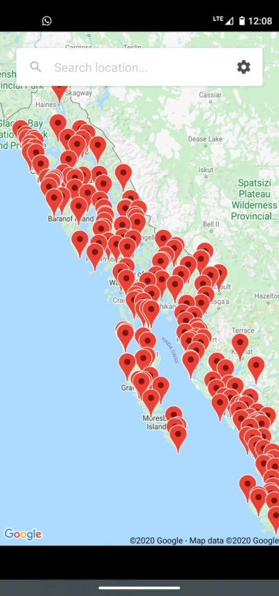
Is there an app for tides that doesn't just give you the nearest tidal station, but uses two or more stations to find/estimate tides at the location where your boat is? This would be for the north coast of BC, so has to be GPS and not one that needs cell phone coverage.

Seems like there could be an app that makes adjustments for location, distance between nearest tidal stations, and the current tidal range to give location specific times and depths.

There is so much water sloshing around in such a complex system here, that things get weird. One location with a large body of water squeezing through a narrow entrance has something like, "High tide between 15 and 45 minutes after high tide in Prince Rupert" (which is about 100 miles away as the crow flies) written on the paper chart. Not very precise!

Would be nice to have a somewhat accurate idea of how much water is over a rock that might be guarding the entrance to an inlet/lagoon.

Thanks a bunch.
 
Last edited:
I don't have my finger on the pulse of all the available apps out there, but figure some of you probably do...

Is there an app for tides that doesn't just give you the nearest tidal station, but uses two or more stations to find/estimate tides at the location where your boat is? This would be for the north coast of BC, so has to be GPS and not one that needs cell phone coverage.

Seems like there could be an app that makes adjustments for location, distance between nearest tidal stations, and the current tidal range to give location specific times and depths.

There is so much water sloshing around in such a complex system here, that things get weird. One location with a large body of water squeezing through a narrow entrance has something like, "High tide between 15 and 45 minutes after high tide in Prince Rupert" (which is about 100 miles away as the crow flies) written on the paper chart. Not very precise!

Would be nice to have a somewhat accurate idea of how much water is over a rock that might be guarding the entrance to an inlet/lagoon.

Thanks a bunch.

Check out "Tide Times."
 
Check out "Tide Times."

You mean My Tide Times?

As far as I can tell, they use the nearest station:
Find the nearest locations to you when the app opens, so you can get tide times no matter where you are!

I'm looking for an app with information between stations. Also, one with the special annotations on paper charts (like the example in the OP) factored in.
 
https://en.m.wikipedia.org/wiki/U.S._Army_Corps_of_Engineers_Bay_Model

Murray,

I’ve attached a link to the “Bay Model” that the US Army Corps of Engineers built in the 1950s and maintain today. It’s a detailed model of San Francisco Bay and California Delta and was built to study the timing and effects of tidal movement in this area. Very fascinating to visit if you ever head this way.

The tidal effects in this region are very complex. Fortunately, the Bay and Delta region has a lot of measuring stations and the apps take them into account. Of course we have millions of people around the Bay and Delta as opposed to BC’s smaller population.

We use a couple of tide prediction apps. The one I use most often is “AyeTides”. But again, it uses densely populated tide stations and is fairly accurate.

I’m going to watch this string closely, because, after visiting the Bay Model through the years, the need for an accurate tide predictor at any location (often between tide measuring stations) is warranted.
 
Last edited:
I'm not sure how much value a app that interpolates tidal change between secondary stations would be. When going to the San Juans this summer, I had one app open and my wife another. I would show slack tide somewhere at 704, her app would say 710. Max ebb at 3.4 knots, hers would be 3 knots. Which one is right? Probably neither. Both are reliable guesses that don't take into account wind, barometric pressure, riparian discharge, and other factors. Just cause it's science doesn't mean it's exact science. Just cause there's an app doesn't mean that it isn't partially a WAG.

Years ago, the UW built a scale model of Puget Sound and made an atlas of currents at different stages of tide. They probably put drops of ink in and logged how they spread when filling and draining the model. It showed interesting little back eddys and upwelling and gave estimates of speed and direction at different points of the tidal change. Fascinating to look at the atlas, but the minutia of detail was probably of little value (mostly racing sailboaters bought the atlases). One of the problems with too much information is that what appears to be more and more accurate is just the opposite.
 
Murray;
I feel your pain. There is no app that I can find that does what you want. Even Windy.com shows only the known stations, which in your area are few and far between.
Try looking for the currents in the passes, even the current stations that are shown in the printed CHS tables don't show up on any apps. I have to check my old, reliable nav program that I bought 25 yrs ago, upgraded to just before they went dark about 10 yrs ago.
App developers? Get on it!
 
This wouldn't do it?
 

Attachments

  • Screenshot_20201001-120841.jpg
    Screenshot_20201001-120841.jpg
    91.4 KB · Views: 80
I have to check my old, reliable nav program that I bought 25 yrs ago, upgraded to just before they went dark about 10 yrs ago.
App developers? Get on it!

Is it Nobeltec Tides and Currents? I think my first version (1985?) came on a floppy drive (remember those?). My wife upgraded as a gift. It was only required because my old version didn't work well with "new" versions of Window. I tried to upgrade again from Windows 7 to 10 and learned that the company had sold out. I now keep an old laptop with windows 7 and Tides and Currents. Easy to look for clam tides a month out or plan next year's cruise to Bella Bella.

I used Windy.com this summer. I think that my wife's app was Navionics. They feel more "ballpark" than Tides and Currents, but maybe that's just the interface.
 
Interesting...my Tides near Me android app seems to work and matches other sources.


Wonder if its a device setting?


Itis nice traveling because it saves you the effort of matching your location with the nearest station, then gives a map to zero in better.


I have had a few unusual observations with OpenCPN trough the years...but more in the current arena.
 
I'm not sure how much value a app that interpolates tidal change between secondary stations would be. When going to the San Juans this summer, I had one app open and my wife another. I would show slack tide somewhere at 704, her app would say 710. Max ebb at 3.4 knots, hers would be 3 knots. Which one is right? Probably neither. Both are reliable guesses that don't take into account wind, barometric pressure, riparian discharge, and other factors. Just cause it's science doesn't mean it's exact science. Just cause there's an app doesn't mean that it isn't partially a WAG.

Years ago, the UW built a scale model of Puget Sound and made an atlas of currents at different stages of tide. They probably put drops of ink in and logged how they spread when filling and draining the model. It showed interesting little back eddys and upwelling and gave estimates of speed and direction at different points of the tidal change. Fascinating to look at the atlas, but the minutia of detail was probably of little value (mostly racing sailboaters bought the atlases). One of the problems with too much information is that what appears to be more and more accurate is just the opposite.
Good post and agree there is enough chaos in the major area of tidal system that Murray is looking at to make predictions (and that's all they are) unreliable. It would have to take into account barometric pressure at the predicted location as well.

I recall seeing that Puget Sound model somewhere in Seattle when I lived there in the early 90s. Fascinating to a geek like me. I watched it cycle through several tides.
 
Last edited:
I really liked Ayetides. Foolish me, I switched to an Android phone and Ayetides isn't available. :(
Ayetide users, you DO know that if you turn your device 90 degrees that the format changes from text to graphical. I really liked that feature. Not available on the apps I've used since I got the Android phone.
 
Would be nice to have a somewhat accurate idea of how much water is over a rock that might be guarding the entrance to an inlet/lagoon.

Forward looking sonar.
 
I don't have my finger on the pulse of all the available apps out there, but figure some of you probably do...

Is there an app for tides that doesn't just give you the nearest tidal station, but uses two or more stations to find/estimate tides at the location where your boat is? This would be for the north coast of BC, so has to be GPS and not one that needs cell phone coverage.

Seems like there could be an app that makes adjustments for location, distance between nearest tidal stations, and the current tidal range to give location specific times and depths.

There is so much water sloshing around in such a complex system here, that things get weird. One location with a large body of water squeezing through a narrow entrance has something like, "High tide between 15 and 45 minutes after high tide in Prince Rupert" (which is about 100 miles away as the crow flies) written on the paper chart. Not very precise!

Would be nice to have a somewhat accurate idea of how much water is over a rock that might be guarding the entrance to an inlet/lagoon.

Thanks a bunch.
I use tidegraph pro but it doesn't estimate between official stations like you are looking for.
 
Opencpn has the worlds tides on it and no internet connection required.
 
Is it Nobeltec Tides and Currents? I think my first version (1985?) came on a floppy drive (remember those?). My wife upgraded as a gift. It was only required because my old version didn't work well with "new" versions of Window. I tried to upgrade again from Windows 7 to 10 and learned that the company had sold out. I now keep an old laptop with windows 7 and Tides and Currents. Easy to look for clam tides a month out or plan next year's cruise to Bella Bella.

I used Windy.com this summer. I think that my wife's app was Navionics. They feel more "ballpark" than Tides and Currents, but maybe that's just the interface.

Nobeltec bought out CAPN, which I use. I think my "Tides and Currents" is the same as Nobeltec, as my last upgrade of CAPN was after that buyout.
I have an old computer on the boat that was tricked into running CAPN, which was never upgraded after about 2010, whatever version of Windows that was.
 
I just removed that app. It seems to be one hour out on all the tides around here and I couldn't get to a setting to change it.

That's the app I have been using and it seems pretty close to me. I've used it in LI Sound and near Tarpon Springs,FL.
 
That's the app I have been using and it seems pretty close to me. I've used it in LI Sound and near Tarpon Springs,FL.

Once I installed My Tide Times I found that it was much more user friendly to use than Tides Near Me. Give it a try and let me know what you think.
 
Thanks all for the input.

Will probably have to wait for real-time tide status reports from a future satellite.
 
Is there an app for tides that doesn't just give you the nearest tidal station, but uses two or more stations to find/estimate tides at the location where your boat is? This would be for the north coast of BC, so has to be GPS and not one that needs cell phone coverage.

Thanks a bunch.


Murray: I’ve talked about this before. There are two issues: uncertainty with tides, uncertainty with soundings.

In my opinion, the 3rd party apps are pretty much useless for what you seek. I’ve found some pretty big errors in some of their predictions, particularly for current stations.

You can download the CHS take on all of this. I build PDF books every year using this website:

https://www.waterlevels.gc.ca/eng/data#s1

I built some spreadsheets that model some of the current stations but they are pretty kludgy to use. To me the biggest issue for the central coast is the lack of currents stations.

My suggestion is to try and dig down and contact CHS with your problem. I’ve sent emails and have gotten quite detailed feedback from the folks there. You will also learn about some of their current projects. Perhaps you could volunteer to be a “citizen scientist“ and you could provide monitoring for a specific location.

https://www.waterlevels.gc.ca/eng/info/faq

chsinfo@dfo-mpo.gc.ca.

Note the “observations stations” for Kitmat:

http://www.pac.dfo-mpo.gc.ca/science/charts-cartes/obs-app/observed-eng.aspx?StationID=09140

Jim
 
Murray: I’ve talked about this before. There are two issues: uncertainty with tides, uncertainty with soundings...

Thanks, Jim.

Yeah...I was navel gazing/whittling on a stick whilst pondering what might be out there. Given the mind numbing number crunching ability of computers these days, I figure it's only a matter of time before something like this becomes available.

Concerning your point #2; we were up Kildala Arm near Falls Creek a while back and found 5' of depth where there should have been 20' :eek: because of all the mountain silt & muck that's been brought out of the mountains since the charts were made.

Do they offset fuel costs for citizen scientist data collection? :D
 
There is an app for everything!
 
Tom said currents matter more, which got me thinking about the topic. Think of the current as a wave as it laps up a beach while you are standing waist deep in the water, as the wave rolls up the beach the water gets deeper where you stand, as it recedes it gets lower. High tide is where it is highest up the beach and low is opposite.

Now apply this to a tide datum location nearest upstream from the point you want to know the depth. On a chart the average low tide measurement is seen for both locations.
If the chart location says 10 feet and the current tide table says 15 feet you know it is 5 feet above average. Add that 5 feet to the down current location chart depth and you have a good guess for tide at that location.

You'd think that..

That is an over simplification of a tremendously complex system.

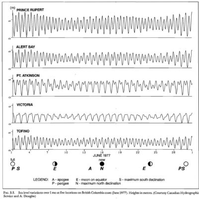
Tides are actually a combination of several different tidal constituents. On our coast some areas are predominantly semidiurnal and some are predominantly diurnal. That's one of the reasons the bumps in the tide charts don't line up.

Another is the coriolis effect which creates a true tidal wave which hits the outer West coast at the same time but is then constricted by friction by changes in depth and width of all if the inlets. This messes up all of the timing once you are off of the ocean proper.

As I write this, high tide in Seymour Narrows is in 12 minutes. High tide in Campbell River, about 6 miles away is almost 2 hours from now.

Crazy.

And that is just the astronomical tides.

Storm surges due to windand low pressure or high pressure systems (Remember air is a column of fluid that exerts a force on the surface) really effect the tides too.

I have a great book on BC Oceanography from the Canadian government that I downloaded for free. It's on my iPad. I'll see if I can find it so you and Murray can download it too. It's really old but very good. IMG_20201018_165711.jpeg
 
Thanks for bring this up, Northern Spy.

The book is

“ CANADIAN SPECIAL PUBLICATION OF FISHERIES AND AQUATIC SCIENCES 56”
Oceanography of the British Columbia Coast
By RICHARD E. THOMSON

Rick Thomson is an interesting guy. He must be retired now. I told him he needed to update this book. He laughed. I think he did it as a post doctoral project. I think it’s 1981.

https://waves-vagues.dfo-mpo.gc.ca/Library/487.pdf

Or you can by it here

https://www.abebooks.com/servlet/Bo...+columbia+coast&cm_sp=snippet-_-srp1-_-title1

Jim
 
Last edited:

Latest posts

Back
Top Bottom