Issues with the Navionics Web App

The friendliest place on the web for anyone who enjoys boating.
If you have answers, please help by responding to the unanswered posts.
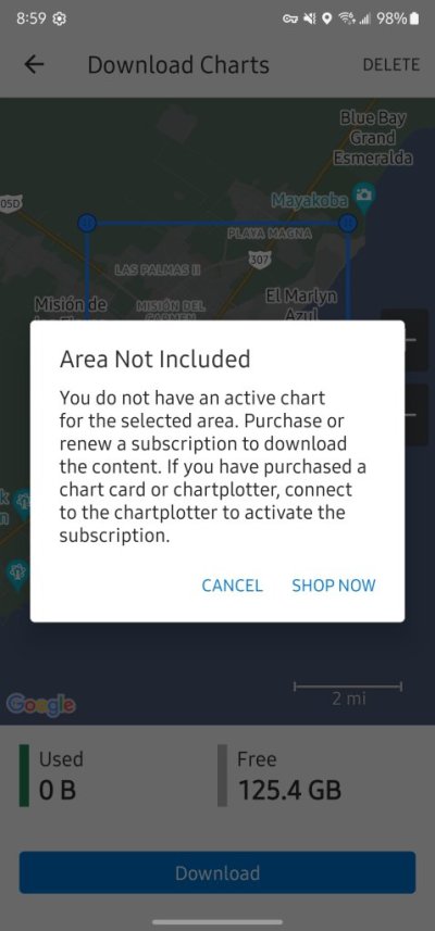
I chatted with a Garmin.com rep who confirmed that while the route planning feature at Navionics.com has been removed, route planning tools are still available at Active Captain. The catch is that your Active Captain account must be linked to at least one chartplotter that has an active chart subscription. That all came as quite a shock to a guy who has been using Navionics on an iPad for $15 a year.

Do other chartplotter and MFD platforms like Raymarine and Simrad have similar annual chart subscription costs?

Route planning tools in ActiveCaptain? I don't think so.......

I purchased a Navionics chip for my Simrad covering Central America to Florida. The level of detail and usability far surpasses the info available on my Android phone and tablet.

I don't understand the hub-bub on this. The Navionics PC-based charting capabilities were always pretty lame compared to other offerings in the market. "Klunky" was an understatement when I looked at it a few years ago.

Storms cause shoals to move pretty quickly which is more of a problem for folks who boat on rivers and the Atlantic/GoM locations so updating their charts regularly is more important than, say, PNW boaters. PIssed me off when the subscription fees for Navionics went up dramatically. But now that the sticker shock has subsided, getting accurate charting information in so many usable formats is pretty impressive. Compared to the old paper chart days, a good value.

BTW - for those who lament to decline of ActiveCaptain, most cruiser-types have migrated to NoForeignLand. It's a very handy app that competes directly with ActiveCaptain and has several additional features such as ability to track other boats.

Peter
 
I have all garmin equipment and and used the navionics web on my laptop for general planning at home before a trip. I am disappointed garmin keeps changing things.
 
Solution found.
Mirror your phone/tablet to PC through Microsoft account Link your Phone. Your phone is mirrored on the PC screen. Keyboard and mouse control the phone. I have Navionics on android phone.

Tip: Place your phone so it is in landscape and then it will mirror and expand on screen landscape. It does not fill the screen as resolution are different. I have full width and 80% vertical. Portrait view is as bad as working on the phone.
 
Route planning tools in ActiveCaptain? I don't think so.......
Apparently route planning functionality is only available in Active Captain if it is paired with a chartplotter. Is that not the case? Garmin and my Garmin rep are telling me that’s how it works.
 
Has anyone noticed what's going on with the Navionics web app lately? I've invested in both the iPhone app and an SD card for my chart plotter, and I frequently use the web app. But now, with the transition to the new Garmin site, it seems like the Navionics web app is gone and everything is really disorganized. Any insights or solutions?
Garmin discontinued the PC based chart viewer. The folks at Garmin apparently think people use phones and tablets exclusively now and not actual computers.

Boo on Garmin.
 
Yes, very short sighted. Has anyone used the route planning tool in Active Captain?
ActiveCaptain does not have route planning. Best I can tell, popularity of ActiveCaptain is waning in favor of NoForeignLand which has really caught-on with international cruisers (meaning ActiveCaptain is probably better for local anchorages and such). Neither have route planning.

You other question on cost for chart subscriptions. Different business model. Coastal Explorer is $399 to buy. Charts are US-ENCs and are free for life. Rose Point Navigation Systems. I was an early adopter of CE back around 2000 or so. I update it every year or two for free. I don't know how they make money but that's been my experience so far.

Everytime I open CE, US ENCs update. I just opened now and had 95 chart updates. If I haven't opened for a few weeks, could be several hundred (also includes ActiveCaptain reviews).


Its a good piece of software that has served me well for almost 25-years.

Peter
 
Are you using Active Captain like I am, Peter? That is, as a standalone app that is not tied to a chartplotter? I don’t see any route planning tools either, but Garmin assures me it exists once Active Captain is paired with a chartplotter.
 
Are you using Active Captain like I am, Peter? That is, as a standalone app that is not tied to a chartplotter? I don’t see any route planning tools either, but Garmin assures me it exists once Active Captain is paired with a chartplotter.

I checked the ActiveCaptain app on my android phone and received the message in attached screenshot. Seems to imply more robust charting of connected to a chartplotter. I do run navionics on my simrad chart plotter so perhaps it's possible to pair charts to ActiveCaptain but I don't know what plotting capabilities there are. And I do not see anything similar on my PC - no such message came up.

Maybe Garmin has a different vision for ActiveCaptain and they intend to use the name for a more robust charting function (it is a pretty good trademark name and implies navigation). But who knows.

All I can tell you is I'm very happy with Coastal Explorer for PC experience, marginally satisfied with OpenCPN. It's been a few years since I checked out Navionics charting on my PC as it felt pretty crude and clunky so I didn't pursue it further. Since Coastal Explorer is only $400 new and has a very generous update policy (I think I've gotten every update for free for 20+ years, but I may have paid for one - I don't remember), I don't know why folks wouldn't go that route for PC based planning. In the scheme of boating, not that much money.

Peter
 

Attachments

  • Screenshot_20240817_085912_ActiveCaptain.jpg
    Screenshot_20240817_085912_ActiveCaptain.jpg
    58.8 KB · Views: 15
Last edited:
Update. I played a bit more with ActiveCaptain app on my Android. I was able to drop a waypoint so there must be some charting capabilities. If I were at my boat, I could connect to the same WiFi network as my Simrad (Navionics) and register charts. So right now all I see are blobs of landmass.

What I do not see in Active Captain are reviews for anchorages. Marinas, etc. I can see them on Navionics, but not on ActiveCaptain. Leads me to believe the open-source nature of ActiveCaptain is no more. I'm guessing next step will be to remove ActiveCaptain reviews from Navionics unless there is an active subscription. If so, not sure how that would effect third parties such as Coastal Explorer who also include ActiveCaptain data. Not a big deal - these days NoForeignLand has won me over.

Peter
 
HERE is a list of compatible chartplotters that Active Captain will work with.
Without these it is a nice map to look at.
 
HERE is a list of compatible chartplotters that Active Captain will work with.
Without these it is a nice map to look at.

Different question. Question is not what chartplotters (and Apps) ActiveCaptain will work with. Question is how to use the PC-based Navionics feature which Garmin states they have migrated to ActiveCaptain (which does not appear to be true).

Two items:

  1. I can find nothing in the PC-based instance of ActiveCaptain that suggests ability to create waypoints or routes, let along synch them to a chartplotter. See attached picture - there is a distance measure, but that's as far as it goes.
  2. I haven't used the ActiveCaptain App in a long time (Android Phone - I updated the App this morning), but as mentioned in a previous post, even reviews are missing on the Android App (they are present in the PC-based application - see attached). It does display speed and bearing, and I was able to create a Waypoint, but without ability to pair to my chartplotter, no chart detail whatsoever. Importantly, to pair, you have to be on the same network as your chartplotter so cannot be done remote.
I use Navionics on my phone, tablet, and Simrad chartplotter. I like it - does a decent enough job in most places (being in Central America these days, there are definitely gaps, but that's a different topic). I am also a user of ActiveCaptain which I access via Navioncis App on my Phone and Android Tablet, or on my PC via Coastal Explorer. But I have effectively replaced ActiveCaptain with NoForeignLand as there are some interesting features that I like.

For those who used the Navionics PC interface for route planning, I am not seeing a decent Garmin-based option. If you're price sensitive and $400 for Coastal Explorer is too much for you, try OpenCPN. For me, it's a twitchy piece of software that sometimes loses charts and there remains a steep learning curve. But it is very feature rich and free. It is not difficult to create a route and save it to a small file and transfer it to your chartplotter as long as it has some flavor of network-connection or a SD card.

Peter


1723908223075.png

Di
 
Peter I think you are missing the message. Active Captain will work with those chartplotters by mirroring the chartplotter, in effect it is a remote control of the chartplotter. That is why you are not finding info on how to plot. You have to go to the chartplotter instructions
 
I used the browser version of Navionics quite a bit and found it sufficiently feature rich for my needs. The Auto Route was limited to a few hundred waypoints, but that was virtually never an issue for me. Manually created routes had no such limit. I don't have much to compare it to, but losing the browser version of Navionics was a big hit for me and I am hoping ActiveCaptain stacks up as a substitute.
 
I am on-board with all the above Garmin/Navionics gripes. Very frustrating.

But: a solution: OpenCPN is a free, well-supported-volunteer-driven solution for PC and Mac with the added advantage of being able to load the FREE NOAA charts directly from NOAA. you already pay for these charts through your taxes, why pay Garmin to get them, screw up the format, and then charge you $150 or so to upload to your plotter. The software is pretty reliable (occasional crash) and well documented. Canadian charts and others come with whatever fee is charged by source, about $35 for Canada.

It's great for planning in front of the fire at home. Tides and currents are built in. Then you can export all your route planning onto a card or stick as a .gpx file, which will upload to the Garmin plotter. Your routes will then appear under User Data.

OpenCPN.org

Also, a $20 GPS USB puck will turn your PC into a real-time navigation display while underway.

Full disclosure: while I use OpenCPN as described above, I do also pay Garmin their tribute to obtain chart updates for use directly on the plotter as I have yet to find a hack to bypass that route for chart updates.
 
I would like to defend Navionics as an Italian company that has mostly done an excellent job with the app.

The greed for profit only exists since Navionics was acquired by Garmin (on October 27, 2017, Navionics was acquired by Garmin Ltd.). Just because Garmin has changed its headquarters from the US to Switzerland, it remains a US company listed on the NASDAQ. The stock market demands profit.

Let me remind you that not only has the web-based routing discussed here been discontinued, but it is also no longer possible to download maps from previous subscriptions in the app. The answer to my query about this to support was revealing: we have changed the policy with an update - it's your own fault if auto-update is activated.
An exciting policy that is difficult to understand in Europe: changing the contractual conditions of the purchased item via an app update after purchase.
 
I solved my problem by getting an android tablet, bigger screen than a phone. I will adapt, you too will be assimilated.
 
I have two Garmin MFDs, a Garmin Fantom Radar, two Garmin VHF radios and a Garmin Fitness watch. So, buying and blowing up home use Navionics is the thanks I get for customer loyalty. C'mon, Garmin, go back to earning a good reputation by putting the PC Maps function on the Navionics former site so we can dream, check distances, balance GPH, SOG, Fuel and chart courses and destinations on which to use all the $thousands of gear I and others bought from you. My boat is 5 hours away - not at all convenient for developing cruise plans on my MFDs.
 
Route planning tools in ActiveCaptain? I don't think so.......

I purchased a Navionics chip for my Simrad covering Central America to Florida. The level of detail and usability far surpasses the info available on my Android phone and tablet.

I don't understand the hub-bub on this. The Navionics PC-based charting capabilities were always pretty lame compared to other offerings in the market. "Klunky" was an understatement when I looked at it a few years ago.

Storms cause shoals to move pretty quickly which is more of a problem for folks who boat on rivers and the Atlantic/GoM locations so updating their charts regularly is more important than, say, PNW boaters. PIssed me off when the subscription fees for Navionics went up dramatically. But now that the sticker shock has subsided, getting accurate charting information in so many usable formats is pretty impressive. Compared to the old paper chart days, a good value.

BTW - for those who lament to decline of ActiveCaptain, most cruiser-types have migrated to NoForeignLand. It's a very handy app that competes directly with ActiveCaptain and has several additional features such as ability to track other boats.

Peter
Peter, I hate to tell you this, but we folks in the GoM and AICW don't get storm-caused shoaling updates on Navionics or any other electronic charts on anything like a dependable basis, and I would go so far as to say I have never seen one. Old Navionics charts work as well as "updated" ones as far as I can tell. Missing nav marks are obtained via USCG Notice to Mariners. Permanently moved buoys? Well, maybe someday you will see them on an updated chart. Back in 2020, I transited the entire AICW and continued round FL to the panhandle using my Coastal Explorer on a couple of laptops, and even though I hit the update button every time I was withing wifi range, I continued to find that one must always be one the lookout for things that just aren't as the chart would have you believe because let's be frank, updates are intended for the big boys transiting big boy channels.
 
Peter, I hate to tell you this, but we folks in the GoM and AICW don't get storm-caused shoaling updates on Navionics or any other electronic charts on anything like a dependable basis, and I would go so far as to say I have never seen one. Old Navionics charts work as well as "updated" ones as far as I can tell. Missing nav marks are obtained via USCG Notice to Mariners. Permanently moved buoys? Well, maybe someday you will see them on an updated chart. Back in 2020, I transited the entire AICW and continued round FL to the panhandle using my Coastal Explorer on a couple of laptops, and even though I hit the update button every time I was withing wifi range, I continued to find that one must always be one the lookout for things that just aren't as the chart would have you believe because let's be frank, updates are intended for the big boys transiting big boy channels.

I live near John's Pass in Madeira Beach FL. The entrance shifts quite a bit through the year and seems to be updated on charts fairly well. The ICW channel doesn't seem to move but the inlets do.

How long does it take for a notice to mariners translate into a chart correction? I have no idea. But I do know that without an active subscription, it will never happen on Navionics.

Difficult to find, but embedded in the ENC data is Zone of Confidence (ZoC) tags that describe how accurate depth soundings are. Vast majority of recreational waters have have fairly low ZoC accuracy .

As always, vigilance and experience rule.

Peter
 
Last edited:

Latest posts

Back
Top Bottom