You are using an out of date browser. It may not display this or other websites correctly.
You should upgrade or use an alternative browser.
You should upgrade or use an alternative browser.
Another “I” storm for SWFL
- Thread starter High Wire
- Start date
The friendliest place on the web for anyone who enjoys boating.
If you have answers, please help by responding to the unanswered posts.
If you have answers, please help by responding to the unanswered posts.

Old Sea Dog
Senior Member
- Joined
- May 13, 2022
- Messages
- 315
- Vessel Name
- "OLD BAY"
- Vessel Make
- 1979 Grand Banks #599
Well hopefully it doesn't spin up too big. House can handle a Cat 1 if I am not there. Anything higher and start losing electric. Ian and Irma were a bit of a mess. Ran generator for 2 weeks.
Blissboat
Guru
A glance at SSTs in the Gulf of Mexico should be all it takes to understand why the NWS is watching Idalia with alarm:
https://www.nhc.noaa.gov/tafb/sst_loop/14_atl.png
https://www.nhc.noaa.gov/tafb/sst_loop/14_atl.png
O C Diver
Guru
- Joined
- Dec 16, 2010
- Messages
- 13,232
- Location
- Fort Myers, Florida
- Vessel Name
- End Of The Line
- Vessel Make
- Trinka 10 Dinghy
It's been an unusually dry summer for us in Fort Myers, but this wasn't how I wanted precipitation.
Ted
Ted
Mambo42
Guru
- Joined
- Oct 26, 2021
- Messages
- 953
- Vessel Name
- Endless Summer
- Vessel Make
- 1979 Defever 49
Heard over a month ago that water temps were unusually high, which is very bad news for hurricane development. 28 degrees Celsius is required for a build up, water temps are at 30 degrees, so this can get ugly real fast.
Hope all of you in the danger area will be safe, don't take your chances with this one, a boat or a house can be replaced, but not your life.
Hope all of you in the danger area will be safe, don't take your chances with this one, a boat or a house can be replaced, but not your life.
fryedaze
Guru
- Joined
- Sep 4, 2011
- Messages
- 1,752
- Location
- USA
- Vessel Name
- Fryedaze
- Vessel Make
- MC 42 (Overseas Co) Monk 42
The Army Corp has Lake Okeechobee at about 15.5 feet. Hurricane season is just starting. If levels get to 16.5 feet. They will start major discharges east and west. If it comes to that the coasts are going to be mess. The Corp has been letting the level rise and the lake algee levels are very high.
Dougcole
Guru
That "M" is never a good thing to see. The trend with every update has been further SE which has pretty much taken us here in Wakulla (on the coast South of Tallahassee) out of the cone and means we will get the weaker side of the storm. But it is very bad for the people SE of us. One more jog and Tampa Bay, with its massive population is square in the crosshairs. Tampa is one of those areas that hasn't really been hit in a long time, many residents there haven't lived in Florida for long and have an odd belief that they are in a "hurricane proof" area. A major hit there would be bad.
Dougcole
Guru
The Army Corp has Lake Okeechobee at about 15.5 feet. Hurricane season is just starting. If levels get to 16.5 feet. They will start major discharges east and west. If it comes to that the coasts are going to be mess. The Corp has been letting the level rise and the lake algee levels are very high.
Great. More red tide.
Archie: I like how the “cone” in your first post updates every time the National Hurricane Center updates theirs.
RT Firefly
Enigma
Greetings,
Latest forecast I saw was Idalia strengthening to a Cat 3 before landfall. Given that Franklin is being pushed eastward I wouldn't be surprised if Idalia shifts a bit to the east as it nears land. Please be safe out there.
Latest forecast I saw was Idalia strengthening to a Cat 3 before landfall. Given that Franklin is being pushed eastward I wouldn't be surprised if Idalia shifts a bit to the east as it nears land. Please be safe out there.
RTF: Bite your tongue. ")
In Jacksonville, we’re all hoping it goes to the west. The current projected path looks like it’s west of Orlando and Jacksonville so the St John’s river won’t flood from precipitation the south like Ian anyway
In Jacksonville, we’re all hoping it goes to the west. The current projected path looks like it’s west of Orlando and Jacksonville so the St John’s river won’t flood from precipitation the south like Ian anyway
Last edited:
Kuncicky
Veteran Member
- Joined
- May 7, 2021
- Messages
- 88
- Vessel Name
- Betty L
- Vessel Make
- 1973 Gulfstar
RTF: Bite your tongue.
In Jacksonville, we’re all hoping it goes to the west. The current projected path looks like it’s west of Orlando and the St John’s River so the river won’t flood from the south anyway.
Actually, the 5 PM NHC advisory did push the predicted path just a tad over to the West from where the 11 AM advisory had it. The least populated area would be for it to come almost straight north from where it is now, just to the west of Tallahassee. Trouble is, that is where I live, and we are still recovering from Hurricane Michael back in October of 2018. So one man's meat is another man's poison I guess.
Bill
RT Firefly
Enigma
Greetings,
Mr. LM. I'm not wishing ill will on anyone but I've been watching the systems and almost everyone coming across from Africa is being blown eastward at some point if there's any N vector.
Mr. LM. I'm not wishing ill will on anyone but I've been watching the systems and almost everyone coming across from Africa is being blown eastward at some point if there's any N vector.
OP
OP
High Wire
Guru
Archie: I like how the “cone” in your first post updates every time the National Hurricane Center updates theirs.
I just copied the link of the nhc map and it updates automatically.
Barking Sands
Guru
- Joined
- Dec 24, 2019
- Messages
- 964
- Location
- United States
- Vessel Name
- M/V Intrigue
- Vessel Make
- 1985 Tung Hwa Senator
All prepped. Removed expensive items like the Garmin stuff and other tools. But I think we will be fine. We are having very high tides though at the moment even without the Hurricane. Sure wish I was on a modern floating dock.
Done with house prep too. Now its time to gain 5 lbs with hurricane snacks and Chili in the crock pot.
Done with house prep too. Now its time to gain 5 lbs with hurricane snacks and Chili in the crock pot.
Kuncicky
Veteran Member
- Joined
- May 7, 2021
- Messages
- 88
- Vessel Name
- Betty L
- Vessel Make
- 1973 Gulfstar
This hurricane is going to do a "Crazy Ivan".
You mean cross the Florida peninsula, go out into the Atlantic, turn south, and come around into the Gulf again? Gosh, I hope not! I do vaguely remember Ivan. About 2003 or 2004 if I remember correctly.
Bill
Comodave
Moderator Emeritus
- Joined
- Jul 2, 2015
- Messages
- 22,251
- Location
- Au Gres, MI
- Vessel Name
- Black Dog
- Vessel Make
- Formula 41PC
This hurricane is going to do a "Crazy Ivan".
Isn’t that where it makes a sudden turn and comes up on you from behind???
OP
OP
High Wire
Guru
Isn’t that where it makes a sudden turn and comes up on you from behind???
With the Atlantic as warm as it is, sure it’s possible.
Comodave
Moderator Emeritus
- Joined
- Jul 2, 2015
- Messages
- 22,251
- Location
- Au Gres, MI
- Vessel Name
- Black Dog
- Vessel Make
- Formula 41PC
Yes, it certainly is warm enough this year. Hopefully it isn’t too bad for the people living there.
Coppercove1
Veteran Member
- Joined
- Mar 18, 2017
- Messages
- 33
- Location
- Canada
- Vessel Name
- Treasure Hunt
- Vessel Make
- Marine Trader LaBelle 44
Yes, it certainly is warm enough this year. Hopefully it isn’t too bad for the people living there.
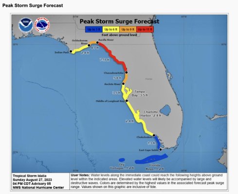
What about the boats in Tampa Bay at marinas? 15 ft of storm surge will probably wipe out piling and leave floats and boats to be washed in with the storm surge.
I hope all the TF people are out of harm’s way!
Barking Sands
Guru
- Joined
- Dec 24, 2019
- Messages
- 964
- Location
- United States
- Vessel Name
- M/V Intrigue
- Vessel Make
- 1985 Tung Hwa Senator
What about the boats in Tampa Bay at marinas? 15 ft of storm surge will probably wipe out piling and leave floats and boats to be washed in with the storm surge.
I hope all the TF people are out of harm’s way!
My opinion is Tampa Bay wont get anywhere near that. Could always be wrong though.
Barking Sands
Guru
- Joined
- Dec 24, 2019
- Messages
- 964
- Location
- United States
- Vessel Name
- M/V Intrigue
- Vessel Make
- 1985 Tung Hwa Senator
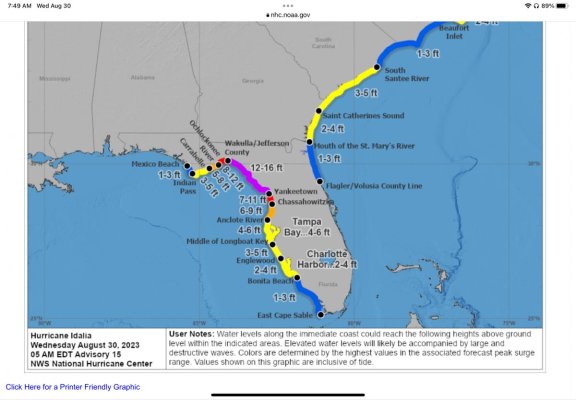
5 am storm surge forecast. 4-6 is still a lot for Tampa Bay but better than north of them.
Yes. The low lying areas will get flooded. My boat at Tarpon appears to have crested 1 foot above the docks and coming down. Hopefully that's the peak. We have another King tide at 1228 this afternoon. In addition the river will swell due to rain. But the wind should be less. Ill be on the boat to see how all that equates.
Barking Sands
Guru
- Joined
- Dec 24, 2019
- Messages
- 964
- Location
- United States
- Vessel Name
- M/V Intrigue
- Vessel Make
- 1985 Tung Hwa Senator
Yes. The low lying areas will get flooded. My boat at Tarpon appears to have crested 1 foot above the docks and coming down. Hopefully that's the peak. We have another King tide at 1228 this afternoon. In addition the river will swell due to rain. But the wind should be less. Ill be on the boat to see how all that equates.
Water levels climbing back up quickly over the last few hours. I wont be able to get to the boat till late afternoon. I would estimate 2 to 3 feet over dock levels.
Similar threads
- Replies
- 23
- Views
- 2K
- Replies
- 5
- Views
- 242