Electronics Question

The friendliest place on the web for anyone who enjoys boating.
If you have answers, please help by responding to the unanswered posts.

captmorgan23

Veteran Member
Joined
Sep 29, 2009
Messages
36
I have a 36' trawler in the Puget Sound area (Port Ludlow to be exact). I am extremely overwhelmed when it comes to what electronics I truly 'NEED'. There is an endless variety of gear and I am having a hard time figuring out where to start. If you are talking to a salesman, you won't be able to survive the night without 3 radar arrays, AIS,fish finders, GPS chartplotters, auto pilot, depth sounders, kitchen sinks, a dozen roses, and a partridge in a pear tree. And then the next guy says "GPS chartplotter is all ya need....hell most people who have radar don't even know how to use it."*

I have 2 VHF radios,one upper on the flybridge, and one in the salon. I also have an older Furuno GPS on the flybridge. So I would love it if the knowledgeable crew in these parts wouldn't mind wading in and at least giving me a bare minimum wish list, as well as a reasonable electronics package that isn't just a gadget fest for gadget fests sake.


Thanks in advance


MP
 
I just noticed that there is a section for Electronics...I apologize to the Admin for my errant posting without looking. If you need to move this feel free, and I will pull my head out of the dark recess I have shoved it.

MP
 
No problem. I think it was a fairly "general" question about electronics.
 
Hiya,
MY OPINION ONLY!!! Capt Morgan, depending on where and when (daylight only or night passages) you boat and common climatic conditions (fog for example) you may be able to "get by" with what you have. Keep in mind, a GPS unit is NO substitute for good, current paper charts and the knowledge of how to read and use them.
I would suggest a good depth sounder for sure (you can probably "shoot thru the hull" negating the need for drilling a hole for the transducer). If your area is prone to fog or you plan on running at night, then radar should be on your list. The last radar I installed was an entry level JRC and was really a "plug and play" unit. Somehat of a no brainer to install.
Auto pilot makes long passages much more enjoyable but is not a "must".
One thing that is on MY, "would like to have" list is stablized binoculars but they're a bit pri$ey for my current situation. Makes picking out that elusive marker easier in less than calm conditions.
Hope this helps...
 
CM: You don't give us much to go on. Do you go out at night? in fog? in high commercial traffic areas? If any of those, radar is very helpful.
I would use a laptop with a nav program rather than a dedicated chart plotter, way cheaper and much better. Wire your exsting uptop GPS down to the laptop in the wheelhouse, then you have GPS in both places. One sounder up top, so you know what you are anchoring in. shoot thru the hull ( if solid FG). You are already good for VHF. Get to know the "Traffic" channel.
The rest is fluff.
 
I have a 37' Europa style trawler moored in Oak Harbor, WA and we run Puget Sound, the Gulf Islands, Desolation, the Broughtons and all the way to SE Alaska.* My suggestion for minimum electronics for the Pacific Northwest are:

- Two VHF Radios (one fixed mount and one handheld), the fixed unit with Digital Selective Calling and an MMSI number
- Radar (gray scale is fine, at least 12nm range)
- Two depth sounders (one fish finder style and one digital only)
- A WAAS capable GPS receiver
- An electronic charting system of some kind (either a GPS/Chart Plotter or a computer based charting program)
- Electronic (and paper) charts for your cruising area.

That said here's what we have installed on Saratoga Sue:

- One DSC capable Uniden UM525 VHF at the lower helm, one older Icom IC-M45 VHF at the upper helm and an Icom handheld VHF (you need DSC and a GPS NMEA signal wired into the radio to send or receive locations).
- A Furuno 1715 radar.
- A Furuno LS4100 fish finder and a Raymarine ST60 digital depth sounder (two is good since one could fail or loose the bottom).
- A computer and 15" display running Coastal Explorer charting software with raster and vector charts for WA, BC and AK.
- A Garmin GPS17xHVS WAAS capable GPS sensor plus a Garmin GPSMap 76 as a backup unit.
- A Brookhouse NMEA multiplexer (allowing multiple NMEA talkers, i.e. AIS, radar, DSC and GPS signals to the computer).
- A Smart Radio SRT-161 AIS receiver (AIS isn't absolutely required but it is a great tool for enhancing your situational awareness and for coordinating passing with commercial traffic).
- A Raymarine ST6001 autopilot with a remote for use on the flybridge.
- A Davis Weather Wizard III wind instrument (great for figuring out when the winds are coming up and you need to start looking for someplace to hide).
 

Attachments

  • 001.jpg
    001.jpg
    78.6 KB · Views: 88
Well, I would prefer the ROSES as we have all the other fluff stuff.**But in order of use: *1) VHF, 2) depth, 3) radar, 4) GPS 5) electronic charts, 5) AIS, 6) autopilot.** However if you are smart, you will get the wife/SO roses! ******
***
Depth and Radar would be my must have fix mounted on the boat for the Puget Sound. **The depth is the first as the depth in the Puget Sound in less that 100 ft the can change several hundred feet. The depth is the number one instrument I use/refer to.**

Radars can serve two purposes*radar, 1) see what is around you and*2) your locations by the land contours with paper charts.* Paper charts are a must weather you have electronic charts or not.* We tend to cruise early in the morning so*we run into fog quite often.*
*

*
As mentioned before having electronic chart on a PC connected to a GPS is the cheapest and in many ways the best way to go.* We used the same Nobeltec software for 11+ years and have loaded it on several computer up grades.* However, you still need paper charts.* I usually have the electronic charts zoomed down to a detail level with a larger bigger area paper chart for an over all view.*
*

*
Since you already have VHF, I will not mention, except having a couple hand held portables does come in handy.* As for AIS, I use http://www.marinetraffic.com/ais/* which shows real time the ships/ferries/commercial/pleasure that have AIS.* We have Verizon wireless broad on our computers,*so*we can also refer to NOAA weather and tides and of course the internet.* *I still question the need to*put out the*AIS as thousands of pleasure and smaller commercial boats do not have.* To me the important thing is knowing what is around you, your present location *and straying out of their way.


-- Edited by Phil Fill on Friday 2nd of October 2009 09:35:10 AM
 
CM: Although I don't cruise in your area, here is what I use the most in Southern California waters.

I'll try and list them in order of importance to me.

Depth indicators (Both fish finder and digital)
GPS chart plotter
Ship's compass (I'm always comparing its heading with the chart plotter)
Auto Pilot (Don't leave home without one...They are sooo helpful)
VHF (Both fixed and hand held)
Radar (Very useful in navigating as well as collision avoidance)
Tide information (From combo unit and checked against paper charts)

Note: There are a lot of other toys that I'd love to have but the above are what I use the most.


-- Edited by SeaHorse II on Friday 2nd of October 2009 10:09:08 AM

-- Edited by SeaHorse II on Friday 2nd of October 2009 10:11:27 AM
 

Attachments

  • helm.jpg
    helm.jpg
    58.1 KB · Views: 110
I actually just found a bunch of info on software based charts and hooking GPS up to my laptop. I will save a TOOOOOON of money going this way, and it looks like it works better(as far as the learning curve). The *wealth of information on this site is awesome and consolidates my research.......daaaamn I love the internet, no need to go to school anymore just go read in a forum. I am MAC based and also have a Verizon wireless card. How is the Verizon card reception throughout the sound? Does somebody want to come to Port Ludlow and be my 'Auto Pilot'?

MP
 
captmorgan23 wrote:

I have a 36' trawler in the Puget Sound area (Port Ludlow to be exact). I am extremely overwhelmed when it comes to what electronics I truly 'NEED'.
We boat in the same waters you're in--- San Juan Islands, Gulf Islands, Desolation Sound, etc.* We boat year round so when it's foggy we go out in the fog.

Basically we have radar, GPS chart plotters, depth and speed displays, and VHF communications.* The boat came with an autopilot but we removed it for a variety of reasons and so far have not felt any need to replace it.

We feel our boat is set up*very well for the kind of boating we do.* We have installed ourselves*all the newer electronics to add capability or*as replacements to equipment that came with the boat that was either failing or could not perform the functions we needed.* We have:

-Two full-size*GPS chartplotters (Echotec and Furuno NavNet VX2)*at the lower helm station*(C-Map).

-Radar (the Furuno NavNet VX2).

-VHF radios (Icom)*at both the upper and lower helm stations.* The lower helm station has a new Icom 504 with a Command Mic remotely mounted in the rear of the main cabin.

- Signet combinatin depth sounder, knotmeter, trip log, elapsed time, etc. displays at both helm stations (came with the boat).

- A Magellen 6000 handheld C-MapNT GPS plotter that we use on the very rare occasionsl we run from the flying bridge.* We also use it on our 17' Arima fishing boat.

- A Furuno Loran-C unit that came with the boat but that we use as a backup and check on the other nav systems.

-* A Standard-Horizon loud-hailer/intercom.

- An Icom waterproof, lithium battery handheld VHF.

- A magnetic compass at each helm station (used to hold a course once the heading is established with the plotters).

In addition to the electronics we carry large US (Maptech) and Canadian chartbooks plus all the NOAA and Canadian full-size charts for all the waters we boat in.* I modified a MapTech chart book holder to sit over the companionway to the forward cabin so when underway we always have the relevant chart open at the helmstation.

I don't believe in using a nav system that runs on a laptop or desk-type computer.* I've read far too many posts on various boating forums*from people who've had these systems crash, lock up, freeze, or malfunction to the point where the computer needed to be rebooted,*always at the most inopportune moment.* Granted, stand-alone nav units are computers, too, but at least they don't depend on an operating system cobbled together by the Microsoft Kids to function.

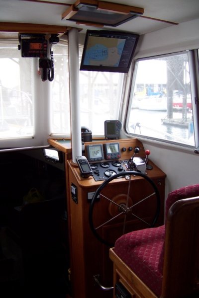
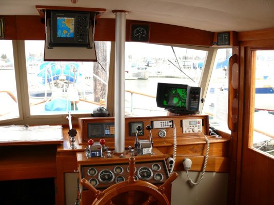
This is a photo of our lower helm station (we virtually never run the boat*from the flying bridge).* This shot was taken before we replaced the Icom 502 with the current Icom 504.

*


-- Edited by Marin on Friday 2nd of October 2009 12:52:28 PM
 

Attachments

  • helm station.jpg
    helm station.jpg
    174 KB · Views: 111
I agree with the cobbled together Microsoft computers being an issue, but I switched to MAC years ago and am still blown away daily at the stability, I can count on 3 fingers how many times my gear has locked up, so I am going to give this a go....and all you Windows, Microsoft fans can start flaming......................NOW!

MP
 
I bought the third Mac sold in Seattle in 1984 to write my first book on. We have stayed with Mac at home since then. Other than having a defective optical drive on my current MacBook when it was brand new, which Apple replaced twice within a week, I cannot recall any instance of a crash, freeze, or other malfunction in all those years.

On the other hand, we use PCs at work (Dell laptops today). My employer has stayed with Windows XP but while it seems relatively stable it has just enough problems to make me not want to do anything with it that I really depend on --- like navigate a boat.

By the way, I still have that first Mac.* I had it upgraded a couple of times to a *double-sided floppy drive and 256k of ram but it's basically the same machine I bought.* I have no idea if it still works---- it's in a box.* But being one of the original run of Macs, the case was made from the mold that had the signatures of all the people who developed the Mac engraved in it.* So if you remove the case, the inside surfaces are covered with signatures in raised lettering.* Steve Jobs, Steve Wozniak, etc.

-- Edited by Marin on Friday 2nd of October 2009 01:54:09 PM
 
I too am a Mac guy.....Bought my first one in 1985 and have been a Mac fan ever since.
The below photo was taken as I wrote this post... in Photo Booth.
 

Attachments

  • photo 1.jpg
    photo 1.jpg
    67.8 KB · Views: 98
VHF ,+ Hand held VHF +hand held ($150)marine GPS ,+ perhaps , autopilot

The rest is nice, but not need to have.

Individual systems don't have as much "club house flash" as the shaft bearing temps overlaying the sat dish aiming system readout , but they have a better chance of working most times.

FF
 
If there is any instrument that I would feel totally naked without, it would be a depth sounder and I like how many of you put it at the top of your list. FF, I am surprised.
 
John:* I couldn't agree more! Not having a depth instrument at the top of your list is like flying a plane with no altimeter. Except for the VHF, most other problems can be solved by eyesight and slowing down. What surprises me is that the auto pilot isn't mentioned more often. Sure, you can hand steer, but anyone who cruises will tell you that an auto pilot sure takes the work out of the trip. Especially for those of us who single hand.
 
The original poster wasn't asking about order of importance, just what sort of electronics would be smart to have on board. If you want to go with importance, all you NEED to navigate the waters around here are paper charts, a lead line, and a compass. The rest of it is all just fluff
smile.gif


I have a friend who's been navigating his Valiant sailboat in the PNW for several decades. He and his family have visited every nook and cranny of Desolation Sound and points north to say nothing of the closer Gulf and San Juan Islands. When it's foggy, he goes out in the fog. The navigation equipment on his boat consists of three items-- a set of charts, a depth finder, and a compass. That's it, even still today. (He does have a VHF radio.) In the fog, he follows depth contours when he gets close to land. He's never gotten lost, never gone aground, and (so far) never been run into or run into anything. He augments his charts, depth finder, and compass with his eyes and ears.

I'm not recommending that this is what we all should do. But the reality is that what you actually need to get a boat safely from Point A to Point B, even in these island, rock, and reef strewn waters with currents up to 10 mph or more, is actually pretty minimal.
 
I was born at Ocean FallsBC, a small paper mill town.* All my dad used was a black plastic hand held compass he carried with him all the time.*There where no charts just directions and land marks; the big rock, the leaning tree, the cabin, the sunken boat. the water fall, the creek. **What they did was stay on a compass heading across the bay/channel until they hit shore, follow the shore until they saw a land mark they knew, then another heading.***When we got lost, *we had to back track until we found a land mark.
*

*
The water fell of quickly and it was deep, so there was not a big concern for running aground.* The boats where maybe 12 to 20 ft and light so they could be pull up on the shore and secured to a tree rock as the tide swing was 10 to 14 ft.* The further north you go the larger the tide swings.* Those of you that have been to desolations sort of have an idea.* **Oh, we always carried a rifle, gun *and knife as there was plenty of wild life.* Dinner was just around the bend.* The stories my dad tells and the little I can remember make today boating a bunch a sissy stuff.**
*

*
So all you really need is a compass, directions, land marks and a rifle/gun//knife.*However, some of you younger newbies may not know what a compass is. *(-; *I use our as a place to put my hat! I have not actually used our compass for years as the computer screen hides it!* )-;****

*


-- Edited by Phil Fill on Saturday 3rd of October 2009 07:59:15 PM
 
Phil--- What is Ocean Falls like today, do you know?
 
The mill is gone so there is only a few year around residents.* It still exists because of the dam that produces electricity for Bella Bella and small villages.* Several boater have made a point of visiting and taking pictures for me.* I have relative in Bella Bella and plan on cruising to OceanFalls.* That is one of the reason we have the Eagle and out fitting for.


*
There is another 58 that cuisse the area year around.* Jim and his dog basically live off the land and sea.* deer, rabbit, salmon, prawns, crab, clams, bottom fish, elk.* He hits a town a couple of times a month for stables. He catches rain water for fresh water or a water fall.* He bought the boat here in Everett, and we hit it off.* He is a retired commercial captain running between Vancouver and Prince Ruepert.**He could make the 58 do things I need a bow and stern thruster for.* We talk to each other every couple of month just to catch up.* Last time I talked to him he was in the Charlets, captaining a local crew boat.* I will have to try calling him, but some times it takes weeks before he calls me back.* I think he is wintering in Lund.**

The stories he told me*brought back memories and scared me to death.* Well not death death as I am still alive.***
biggrin.gif
**

***
*** *
 
FF, I am surprised.

Don't be, I have been boating since the late 50's and have NEVER had an installed depth sounder.

A marked pole and a lead line , along with paper charts takes care of unintentional grounding.

KISS , never fails like a crutch may,

FF
 
Marin,I like the drop down Chart Plotter at your lower helm. Is it a custom install?
Steve
 
John--- It's not a drop down table. It's a MapTech chartboard (which they haven't offered for years) that we bought at a boat show. We reinforced it and modified it with feet and a short hinged leaf on the left side so it will sit level over the companionway to the forward cabin.
 
Actually I was referring to the hinged drop down overhead.
Steve
 
Sorry--- I don't think of that as a chart plotter but the radar. It's actually a Furuno NavNet VX2 that replaced the old Raytheon 2600 radar that came with the boat. The retractable mount is a custom-install. The radar/plotter retracts into a box under the flying bridge consol.
 
Furuno Navnet is an excellent choice!!!
 
We're really happy with it. I would recommend the 10" screen version to anyone contemplating buying one. Unfortunately the 10" unit wouldn't fit on our retractable mount without making a bunch of modifications to the mount that I didn't want to make, so we went with the 7" version. Given how close the display is to the helmsperson, the 7" is actually just fine for our application, but I would still recommend the 10" to someone who has the space to mount it.

My only complaint with the NavNet is that in the plotter chart display mode, so far as I've been able to determine, there is no way to increase the size of the waypoint text labels. They are very small and with older eyes, reading glasses are a must if one wants to read the name of the waypoint on the display. We've not found it to be much of an issue since we rarely need to get the waypoint name off the chart anyway, but it would be nice to be able to increase the font size on the chart display.
 
Back
Top Bottom