garmin inReach

The friendliest place on the web for anyone who enjoys boating.
If you have answers, please help by responding to the unanswered posts.

sbu22

Guru
Joined
Mar 16, 2011
Messages
1,253
Location
US
Vessel Name
Panache
Vessel Make
Viking 43 Double Cabin '76
Anyone famialiar with inReach? My son is sailing Galveston to Key West right now. They're carrying inReach. I'm not familiar with it. They bought it just before departure.. I've gotten 1 test message when they were still at the dock. Nada since over the last 2 days.

The internet address for tracking (as provided to me) is an address format as follows: inr.ch/X#XXX#X

That address gives me a map with the location of the test transmission and the text message.

Assuming they're carrying the unit and it's turned on:

1) Is it supposed to be a continuous feed and update or periodic updates? or

2) Is the user supposed to send updates as they see fit?

This is not posted out of concern - they're grown men and good sailors. Just trying to got a handle on this system. Looks like it has potential for real voyagers.

Appreciate the help.
 
If the Inrerach is on and tracking and you have a link to the tracking website it will be regularly updated. The device can be set to record a waypoint at variable intervals, every minute, every 10 minutes etc.
 
If you still have the test text message in your phone, you can reply to it. The address of the text will not work. You can only reply to a received text message.

The texts aren't instantaneous like cellular. It can take hours depending on satellite availability.

Send him a text to send you the URL.

This is my Inreach URL:

https://share.garmin.com/EdwardGreen

It will give you an idea of what it looks like. Mine drops a waypoint every 10 minutes when I'm moving.

Ted
 
Just what Ted said!
I have an Inreach and feel it gives some great capabilities. I often travel where there is no cellular coverage, and even VHF coverage is spotty. Having the ability to send and receive texts as well as send an "emergency request for assistance" with this device is reassuring. My Inreach web page requires a password, and I have only given out "permission" for a few people to contact me. However, if anyone receives a text from your device, they can respond.

My family loves being able to see where we are at any given point in time. If the device has not been activated properly, or turned on the device and enabled tracking it may not be dropping any waypoints?
 
Like Ted said, the message your son sends you with his Inreach will have a link in it, which will take you to Inreach central. You can then see his course plotted every x minutes depending on his settings, and you can send him a return message. As Tom mentioned above, Inreach was a game-changer devise when it was introduced, and still is. We use it more than sat phone when we're out of cell range based its functionality and lower cost per message. Works well in the very mountainous areas of BC and Alaska, sometimes with a time delay for a satellite to get over you.
 
Last edited:
The story is that someone on the crew obtained the inReach a day or so prior to departure. So I'm unsure as to their prowess in initializing it and - I'm getting the contact info through my lovely but very right-brained DIL. May be some loss in translation.

This sounds like an excellent alt to the satphone. Really appreciate the info, gents.
 
I'm going to introduce thread drift, in what I think is a good direction.

As an inreach user who has benefited from the service in a less than good situation. Dead in the water, middle of the night. Beyond cell range. Beyond effective VHF comms. The most important thing an inreach user can do is select a good shore side support contact. A person who takes their responsibility seriously, keeps up to date on your position and itinerary. Knows how to contact help.

It all worked out for the best but is was most reassuring to get a quick response from my emergency contact. Dive back into the engine room. Come up later for an update to find the USCG had been alerted and was standing by.

It all worked out OK. We got running again and made it to safe harbor under our own power. But..... had we not been able to get running again it would have been a huge assist.

And it works the other way. A buddy got an inreach msg to call home regarding a medical situation.

In other words, as good as the inreach is, it's only as good as the person on the other end.
 
The most important thing an inreach user can do is select a good shore side support contact.

Yep, Portage, I think that may be the missing link - and, perhaps, an inexperienced user.

I don't see this as thread drift at all. Thanks
 
The tracking interval of an inReach is a setting, and can be anything from manually initiated messages to automatic 10 minute intervals. The subscription to have frequent intervals costs more, and perhaps they didn't pay for that version. Once subscribed and properly enabled, you get a webpage with each tracking message displayed. That has to be designated public in its settings, or you will need a login to view it.
 
I did some reading on inreach - seems like a lot of fundamental capability at a reasonable cost (both hardware & use fees) if you're a voyager in remote areas. Texas to Key West direct is fairly remote.

With T-Mobil opening up its Gulf service this summer, there's cell coverage a substantial distance offshore from Houston to Mobile. https://www.tmonews.com/2019/07/t-mobile-4g-lte-coverage-gulf-mexico/

Thanks everyone for the informed input.
 
If you still have the test text message in your phone, you can reply to it. The address of the text will not work. You can only reply to a received text message.

The texts aren't instantaneous like cellular. It can take hours depending on satellite availability.

Send him a text to send you the URL.

This is my Inreach URL:

https://share.garmin.com/EdwardGreen

It will give you an idea of what it looks like. Mine drops a waypoint every 10 minutes when I'm moving.

Ted

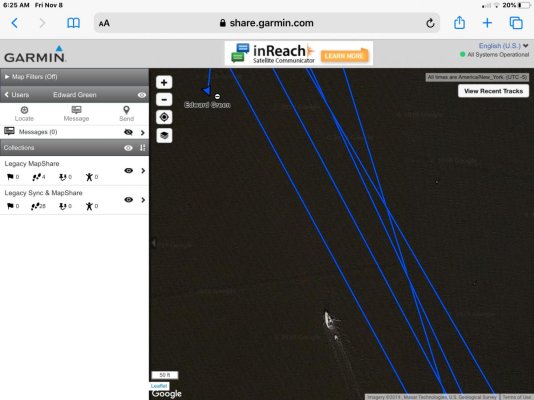
Ted I looked at your In Reach position. When I zoomed in I see a sailboat with a tender headed toward you. (Lower center of photo) Am I correct in assuming that your position is overlaid on a older satellite photograph?
 

Attachments

  • 265AA87E-4601-4BC7-BD69-FCC28E819693.jpg
    265AA87E-4601-4BC7-BD69-FCC28E819693.jpg
    105.5 KB · Views: 60
I've been thinking of getting one and then switching it on just for the months we are out of country. Not a bad subscription cost.

Maybe a Christmas pressie! :)
 
I've been thinking of getting one and then switching it on Justin for the months we are out of country. Not a bad subscription cost.

Maybe a Christmas pressie! :)

I have an InReach, I only turn it on when I’m going beyond cell service on the boat. I used to take it to Europe but now my cell phone works there so no need.
 
inReach position reports are not the same as something like AIS, essentially not real time. If the inReach cannot find a satellite for its report, it will store it and send it later. There can sometimes be several hours delay, though more typically it is a few minutes. The conjunction of a many minutes old satellite message with a months or years old satellite picture may have little relationship to reality.

A big advantage of inReach messaging is that it is sent until receipt is confirmed (unlike Spot), the coverage is worldwide, and their SOS call for help facility can be nuanced, unlike an EPRIB.
 
Ted I looked at your In Reach position. When I zoomed in I see a sailboat with a tender headed toward you. (Lower center of photo) Am I correct in assuming that your position is overlaid on a older satellite photograph?

Yes, it's over an old satellite picture.

That is correct and you will notice Ted has mastered going over, not under bridges.

That took some practice. There's a spot on the Western Erie canal where it goes over a road. That's where I learned to cross over.

Lot to be said for experience. Lol

Yes there is. When it comes to bad outcomes though, I prefer to learn from other people's experiences.

Ted
 
"Yes there is. When it comes to bad outcomes though, I prefer to learn from other people's experiences."
Just wondering Ted...... How many years of university to it take to figure that out?? :)
My son took 4 :) Me, a little longer!
 
"Yes there is. When it comes to bad outcomes though, I prefer to learn from other people's experiences."
Just wondering Ted...... How many years of university to it take to figure that out?? :)
My son took 4 :) Me, a little longer!

I did 1.5 years at the university and then became a "Born again Capitalist". Went through a 6 year apprenticeship before setting up my own store. Was self employed for the rest of my working days.

Ted
 
The most important thing an inreach user can do is select a good shore side support contact. A person who takes their responsibility seriously, keeps up to date on your position and itinerary. Knows how to contact help.

100% agree. I have used inReach for years, and used it a couple of years ago when myself and a friend got trapped in a very serious situation, and the key was the people who I was communicating with.

Yes, you can press the SOS button and there are competent folks that will help you there, but more often than not, the emergency is serious but not serious enough to call out the coast guard, search and rescue, etc.

As an aside, I've been testing the new GPSMAP 86sci which is the updated Garmin + inReach version that came out recently. Really nice feature set as it includes Garmin's marine maps and some other nice features.
 
They can set it up to broadcast a message every morning when they start out. We send, we are getting underway ….. follow us. It has a map link attached. We also send a 2nd message when we get where we are going that we got there safely. It also has the link attached.

IF your test link still connects to the initial map then you can still see them IF, as said, they have turned it on. We religiously have our inReach AND our VIRB camera in our startup sequence.

In the upper right hand corner of the map is a link View all Tracks. Clicking on that will show all of the tracks recorded so far.

Keep in mind that the inReach battery should last a day if fully charged before use.

There is a lot to the inReach, much, MUCH better than the Spot as inReach keeps all of your tracks since you started, Spot you need to offload theirs from the site to keep them.

A lot more to it. Send me a private message and we'll setup some discussions.
 
So, just about to put it on the list I am giving the missus for Christmas - is the Explorer+ the way to go - then the monthly subscription when we need it?
 
menzies,
That is the way I decided to go, 2 seasons now. You can stop service when you want, as long as you remember to stop before your billing date (or else another month). Depending on your expected usage (number of texts) just pick your plan. I am happy with mine so far.
 
menzies,
That is the way I decided to go, 2 seasons now. You can stop service when you want, as long as you remember to stop before your billing date (or else another month). Depending on your expected usage (number of texts) just pick your plan. I am happy with mine so far.

Thanks!
 
There doesn't seem to be many, if any discounts, on Garmin products.

Looks though that Garmin is discounting the Explorer+ (https://buy.garmin.com/en-US/US/p/561269/pn/010-01735-10) which is the 1 I bought. While I haven't used it, the + has maps where the SE doesn't.

We turn the monthly on in the beginning of the season, off when we are done cruising, which BTW you can't do with Spot, you pay a year whether you use it or not. Plus they don't keep your tracks.

We've used inReach for 4yrs now.

Great company for support and product.

Any specific question, private message me.
 
I would look at the new GPSMAP 86sci as well. The Explorer and Explorer + are the 1st Garmin combined products after they bought DeLorme and were sort of an unfinished merge.

I am testing the GPSMAP 86sci and it is essentially a high end Garmin GPS with excellent maps along with the inReach functionality. Definitely a far more featured product than the Explorer Series.
 
Back
Top Bottom