Helene Hurricane Preparation Fort Myers, FL

The friendliest place on the web for anyone who enjoys boating.
If you have answers, please help by responding to the unanswered posts.

O C Diver

Guru
Joined
Dec 16, 2010
Messages
13,216
Location
Fort Myers, Florida
Vessel Name
End Of The Line
Vessel Make
Trinka 10 Dinghy
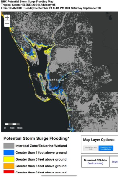
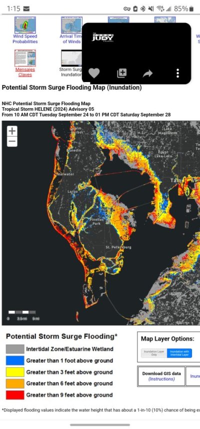
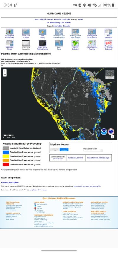
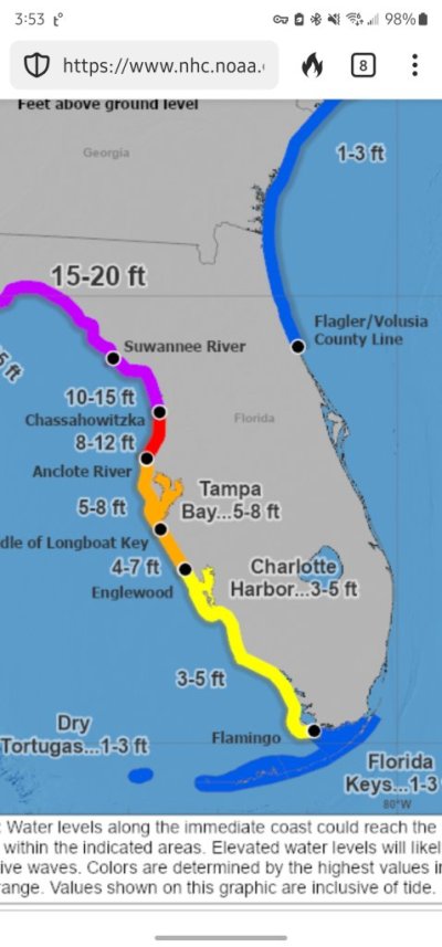
As was discussed in other threads about losses from Hurricane Ian in the Fort Myers, FL area, today is the day to make your plan! The possibility of a tropical storm / Hurricane Helene is very likely with the possibility of it reaching the Fort Myers area starting Thursday.

If it were me, depending on tomorrow morning's forecast, I would be taking my boat tomorrow morning up the Okeechobee waterway to Moore Haven. I would likely tie up at the Moore Haven town docks for the night and decide whether to cross to Stuart, FL on Wednesday based on the forecast.

I no longer own my trawler, so it's not an issue, but waiting till tomorrow to plan and leaving on Wednesday could be a problem with congestion at the locks.

Hopefully this storm doesn't develop. Stay Safe!

Ted
 
Here is the National Hurricane Center storm tracker. It's a fast moving storm and is currently forecast to be well west of the central Florida gulf coast, though as Ted suggests, that can change quickly. RIght now, >90% likliehood of storm formation.


Peter

1727100339419.png
 
As of 0730 Tuesday, the storm is eithr barely developed or not. Wind sheer is still robbing the center of vertical development.

The very last words of all the major forecasters are "we still don't know a lot about the storm and it's development". They have a good idea...especially about the time of landfall, but not the exact location or intensification. Almost all info being put out is still "highly uncertain" based on models that begin with a good amount of uncertainty.

I am headed for Vicksburg, MS tonight along I-20, headed back to for Ft Pierce, FL. I don't know whether to beat the storm or follow it. Too soon to tell, maybe tomorrow will bring a bit more certainty to wise decisions.
 
O C Diver,
If it were me, depending on tomorrow morning's forecast, I would be taking my boat tomorrow morning up the Okeechobee waterway to Moore Haven. I would likely tie up at the Moore Haven town docks for the night and decide whether to cross to Stuart, FL on Wednesday based on the forecast.

Ted, that's pretty much where WE are right now. Between Moore Haven and LaBelle, just off of the Caloosahatchee Canal. We'll doubling up the lines on the boats on the docks, but pretty much figure that for us, this will be a non-event.
Unless storm surge exceeds about 10', I'm confident you'll be fine above the Franklin lock. If it were me, I would contact the Franklin lock to know at what storm surge level they would open the lock. For Ian, they opened the lock creating a higher storm surge in LaBelle. My choice for Moore Haven was because it's above the Ortona lock which wasn't opened for Ian.

Ted
 
If I were in Ft Myers area, I'd keep an eye out for changes, but right now wouldn't make any movements.

Storm surge forecast is 3-feet right now.

Where I live in the Madeira Beach area is a different matter - surge (second pic) is forecast to be much higher. If Weebles were there, I still wouldn't worry because she'll be on a boat lift and can withstand at least 6-foot of surge.

Peter
 

Attachments

  • Screenshot_20240924_131009_DuckDuckGo.jpg
    Screenshot_20240924_131009_DuckDuckGo.jpg
    153.7 KB · Views: 8
  • Screenshot_20240924_131504_DuckDuckGo.jpg
    Screenshot_20240924_131504_DuckDuckGo.jpg
    116.1 KB · Views: 9
Last edited:
Unless storm surge exceeds about 10', I'm confident you'll be fine above the Franklin lock. If it were me, I would contact the Franklin lock to know at what storm surge level they would open the lock. For Ian, they opened the lock creating a higher storm surge in LaBelle. My choice for Moore Haven was because it's above the Ortona lock which wasn't opened for Ian.

Ted
We are in Turkey Creek neighborhood, which is just above Ortona Lock, so I feel pretty comfortable. . . . not complacent, but comfortable. That doesn't mean that we're not going to be out picking up loose stuff, doubling up on mooring lines etc though . . .
 
Based on how "certain" all these weather guys are for track and intensity (even though their bottom line is still...we really don't know for sure) I would be headed East to minimize and surge and wind. Wind can screw you up as bad as surge in some ways, making simple tasks not so simple.

Yep...... I would be enroute to Indiantown right now and when seeing what the final track is, stay put or head East to the ICW then South if I see the wind field data says "better" further South.
 
We are in Turkey Creek neighborhood, which is just above Ortona Lock, so I feel pretty comfortable. . . . not complacent, but comfortable. That doesn't mean that we're not going to be out picking up loose stuff, doubling up on mooring lines etc though . . .
Yes, Turkey Creek is a good place to stay. A departed member of the forum (FF) was there and I stayed at his dock several times.

Ted
 
Even though I am in SE Florida and the winds shouldn't go above 40 mph, I decided to seize the opportunity anyway. I took the canvas down and brought it to the canvas shop for restitching.
 
Question: NOAA / NHC has two products - a "Surge Inundation Forecast" (the 'black' picture attached) and the "Peak Surge Forecast" ('blue' pictures). The Surge Inundation projection has changed a lot since Tuesday (compare black below with Post #10). But the Peak Inundation hasn't budged.

Anyone know the difference between the two? To my eyes, they look like they should be two views of the same data. The Inundation model looks much more precise so hoping it's more accurate. But maybe there's more of a difference than I'm conjuring?

Thoughts?

Peter
 

Attachments

  • Screenshot_20240926_035421_DuckDuckGo.jpg
    Screenshot_20240926_035421_DuckDuckGo.jpg
    97.9 KB · Views: 8
  • Screenshot_20240926_035356_DuckDuckGo.jpg
    Screenshot_20240926_035356_DuckDuckGo.jpg
    70.1 KB · Views: 8
For all those boaters that believe that most boaters prepare their boats well for hurricanes and insurance companies are just bad...look at some of the Big Bend marinas in the weather reports today that still have a lot of boats in the water and poorly prepared. Possibly 20 ft storm surge and 130 mph winds.... yeah.... with 3 or 4 days warning and only a 100 to 150 miles to a relative safer situation.

I still see at least one bimini top up on a big boat and many with some canvas still on them.

Hope most have liability only insurance...... if that.

I'm in Playa del Carmen, 45 miles south of Cancun. There's a panga fleet that moors off the beach. They were all dragged up the sand a couple days ago. Chances are they have zero insurance so rely on themselves to keep their livelihood productive.
 

Attachments

  • 20240926_065701.jpg
    20240926_065701.jpg
    146.8 KB · Views: 8
  • 20240926_065708.jpg
    20240926_065708.jpg
    105.6 KB · Views: 9
  • 20240926_065634.jpg
    20240926_065634.jpg
    134.1 KB · Views: 8
My point was directed at those that believe they do what's best for their boat/marina/yacht club.... think that many/all boaters do. While at least partly true, there are enough boaters that figure insurance is good enough that we all pay for it.

I always suspected that with my dealings with the average boater over 50 years, (especially the last 35) have been confirmed by multiple adjusters/lenders through those years too..... about general boat care attitude. I figured live, color pictures may also be a bit convincing, but will admit, I don't know all those boaters circumstances. To which I have to question....any contingency plans if they can't attend to their boats considering they are in a prime hurricane hit area during the near peak of hurricane season? At least take down the canvas and secure the boats better?
 
Hats off to the National Hurricane Center, whose accuracy with Helene has been impressive. Even when it was a disorganized low in the western Caribbean, they called it to do almost exactly what it is doing tonight, heading ashore in the Big Bend as a major hurricane with a sprawling wind field.

The NHC's capabilities keep improving, thanks to more powerful hardware and software resources, and an ever-growing database for those resources to harvest. Still, future tropical storms may resist being as predictable as Helene, whose environmental factors were sharply defined and changed little during Helene's relatively brief life span, growing quickly from a numbered tropical depression to a named TS and then into an unusually fast-moving hurricane.

Not taking anything away from the forecasters, though. For anyone who was paying attention, there should have been few surprises this time, although with less than normal time to react.
 
Back
Top Bottom