You are using an out of date browser. It may not display this or other websites correctly.
You should upgrade or use an alternative browser.
You should upgrade or use an alternative browser.
How accurate do you think your GPS position is?
- Thread starter O C Diver
- Start date
The friendliest place on the web for anyone who enjoys boating.
If you have answers, please help by responding to the unanswered posts.
If you have answers, please help by responding to the unanswered posts.

Marco Flamingo
Guru
- Joined
- Jan 7, 2020
- Messages
- 1,173
- Location
- United States
- Vessel Name
- CHiTON
- Vessel Make
- Tung Hwa Clipper 30
Going up a river one time, I was following the channel and I noticed that the MFD showed me out in the woods. It just wasn't that accurate. On the return, I was up on plane and followed the track going in even though it went into the woods. Then I thought how do I know it's accurate then (and now) and I never again really trusted Gps for that kind of accuracy.
My GPS system now has something that supposedly warns me if the accuracy is off by more than 50 ft. How does it know it's off by 50 ft? I've never trusted or used it as an anchor watch.
I have the same issue when in my slip and left the GPS on for a few days. What is interesting is, not only have I bounced around according to the GPS, but I've also traveled miles and miles. It is no fair to use the GPS odometer to calculate miles per gallon. The GPS odometer will show an additional 10 miles while you were at anchor.
twistedtree
Guru
So if the 3 GPS satellite compass is a more accurate position, how does it figure out your most likely position? Is it based on voting logic where it averages the closest 2 out of 3?
Ted
I have no idea. If nothing else, it knows how far apart and the orientation of the three receivers, so if they individually indicate something other than the actual separation, the system knows the error. Beyond that it's all just conceptual.
A GPS does report it's HDOP number which is the horizontal dilution of precision. But I can't figure out how that translates into a circle of uncertainly of some dimension. Maybe someone else knows? All I can say is that a smaller number is better. The Sat compass has an HDOP of 0.8 and my Furuno GP330B mushroom reports 1.0.
twistedtree
Guru
Going up a river one time, I was following the channel and I noticed that the MFD showed me out in the woods. It just wasn't that accurate. On the return, I was up on plane and followed the track going in even though it went into the woods. Then I thought how do I know it's accurate then (and now) and I never again really trusted Gps for that kind of accuracy.
My GPS system now has something that supposedly warns me if the accuracy is off by more than 50 ft. How does it know it's off by 50 ft? I've never trusted or used it as an anchor watch.
I have the same issue when in my slip and left the GPS on for a few days. What is interesting is, not only have I bounced around according to the GPS, but I've also traveled miles and miles. It is no fair to use the GPS odometer to calculate miles per gallon. The GPS odometer will show an additional 10 miles while you were at anchor.
That sounds like as much a case of charts that aren't geo-referenced correctly, as variation in the GPS's calculated position. This is what psneeld mentioned earlier. Incorrectly "located" charts are not uncommon.
AlaskaProf
Guru
- Joined
- Jun 26, 2016
- Messages
- 2,291
- Location
- US of A
- Vessel Name
- boatless, ex: Seeadler
- Vessel Make
- RAWSON 41
I think it depends on the device. On my phone per GPS my boat has traveled while on anchor 100s of miles away and returned at times.
Your phone is probably not "WAAS enabled." See above chart.
psneeld
Guru
I used GPS pretty much every day for weeks at a time and off and on several times a week for hours on end in 2 careers since GPS's inception to now. That's using dozens and dozens of different GPS on various boats.
I don't think I have ever encountered the huge errors being reported. If I did, they were quickly forgotten as rare anomalies and I still think GPS is amazingly accurate the vast majority of the time.
PS: just checked my phone GPS for the 3rd time in the last hour, still dead on. Now staring at it for minutes, it has never left a 10 foot (probably 5 foot) radius.
Last edited:
rslifkin
Guru
- Joined
- Aug 20, 2019
- Messages
- 7,946
- Location
- Rochester, NY
- Vessel Name
- Hour Glass
- Vessel Make
- Chris Craft 381 Catalina
I agree with everyone saying that for the most part, GPS will reliably locate you to within a few feet. In our home slip, the chartplotter reliably shows us in the correct slip. And I've never seen any meaningful error.
AlaskaProf
Guru
- Joined
- Jun 26, 2016
- Messages
- 2,291
- Location
- US of A
- Vessel Name
- boatless, ex: Seeadler
- Vessel Make
- RAWSON 41
So if the 3 GPS satellite compass is a more accurate position, how does it figure out your most likely position? Is it based on voting logic where it averages the closest 2 out of 3?
Ted
No. Previous generation Inertial Nav, DECCA systems involved voting. GPS is really a simpler system than it appears:
One of my earliest nautical memories is my Dad showing me how to do a "bow-and-beam" calculation, which I later realized is just an intersection of two "lines of position."
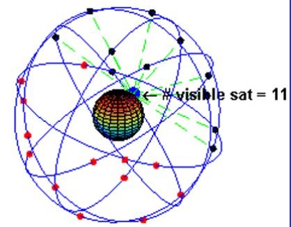
Your GPS receives multiple timed signals from orbit (11,000 miles at a minimum), which it perceives as "spheres of position", i.e. all the places which can be X nanoseconds from one satellite which has sent a time signal.
It discards most of them as absurdities and forms a circle of position. Where it intersects a circle of position from another satellite, two of those positions are on surface of the Earth. A third satellite will resolve the ambiguity.
BUT!: The lower the satellites are on your horizon i.e. the greater the range, the greater the HDOP, which is why that is a constantly changing number, as satellites constantly rise/set.
The pic below is actually a gif for 45N, near my house. I regret I can't share the dynamic process.
Pedantically,
Alaska prof
Attachments
Last edited:
Comodave
Moderator Emeritus
- Joined
- Jul 2, 2015
- Messages
- 22,186
- Location
- Au Gres, MI
- Vessel Name
- Black Dog
- Vessel Make
- Formula 41PC
So I'm anchored for the next day and a half waiting out a storm in the Great Lakes. I'm anchored in a very protected cove (more like a lake that's 2/10 of a mile in diameter). The water is 9' deep with a fair amount of weed on the bottom. Anchor was thoroughly buried from 25 knot gusts from the South this morning. Front came through, and the gusts are now out of the North.
So the boat swings in an arc and drags through the weeds. The anchor likely pivoted or maybe popped out and reset.
Problem is that the MFDs tell you to the foot (maybe less) how far you are from your MOB anchor mark. I have no worries about my anchor, rode, scope, and can drag a couple hundred feet without issue. What I'm interested in knowing is when the display tells me I'm 112' from my anchor drop, how accurate is the mark from yesterday's drop of the hook and this afternoon's position. Yes, I understand that my GPS antenna is 15' from the bow roller which makes it a 30' error in this situation.
So what do you think the accuracy (same GPS numbers for the same position, repeatability) of your unit is, 24 hours apart? Don't tell me what your owner's manual says, tell me based on your experience.
Ted
Did you get a lot of rain today? We had torrential rains on and off today along with a lot of wind.
OP
OP
O C Diver
Guru
- Joined
- Dec 16, 2010
- Messages
- 13,217
- Location
- Fort Myers, Florida
- Vessel Name
- End Of The Line
- Vessel Make
- Trinka 10 Dinghy
Did you get a lot of rain today? We had torrential rains on and off today along with a lot of wind.
Lots of rain from 8am to 1pm. Maybe a couple of 30 knot gusts. Wave heights probably reached 6 inches.
Ted
Phones are rarely if ever WAAS corrected. However even pretty cheap GPS modules now are (you can buy these for <$4).
In another sport (racing sailplanes), I have looked at literally hundreds of thousands of individual GPS fixes from dozens of different receivers. None of them expensive (but all of them modern). There is really no meaningful inaccuracy except in very rare cases. If you are talking about ancient receivers, or ones that are not processing a WAAS signal, then it can be off by a bit, and there can be "fliers". Or if, due to obstruction of the sky, very poor satellite geometry results. In that case the HDOP will show it. Again modern receivers are usually tracking 15 or 20 satellites and using the ones with the best geometry.
In another sport (racing sailplanes), I have looked at literally hundreds of thousands of individual GPS fixes from dozens of different receivers. None of them expensive (but all of them modern). There is really no meaningful inaccuracy except in very rare cases. If you are talking about ancient receivers, or ones that are not processing a WAAS signal, then it can be off by a bit, and there can be "fliers". Or if, due to obstruction of the sky, very poor satellite geometry results. In that case the HDOP will show it. Again modern receivers are usually tracking 15 or 20 satellites and using the ones with the best geometry.
tpbrady
Guru
GPS accuracy is determined by the timing accuracy. One of the biggest errors in timing is caused by changes in the speed of the GPS signal traveling through the earth’s atmosphere. John Deere used to operate and probably still does a network that uses ground based stations in farm areas that are able to measure propagation delay and transmit corrections to their GPS equipment in farm equipment to allow centimeter accuracy. Most GPS systems obtain accuracy by averaging readings, but they all depend on a accurate clock.
Tom
Tom
JDCAVE
Guru
- Joined
- Apr 3, 2011
- Messages
- 3,010
- Location
- Canada
- Vessel Name
- Phoenix Hunter
- Vessel Make
- Kadey Krogen 42 (1985)
I have no idea. If nothing else, it knows how far apart and the orientation of the three receivers, so if they individually indicate something other than the actual separation, the system knows the error. Beyond that it's all just conceptual.
A GPS does report it's HDOP number which is the horizontal dilution of precision. But I can't figure out how that translates into a circle of uncertainly of some dimension. Maybe someone else knows? All I can say is that a smaller number is better. The Sat compass has an HDOP of 0.8 and my Furuno GP330B mushroom reports 1.0.
My iPad with charts reports an HPE of 10-15’. No indication accurate that is, or how that is derived. In the early days of my installation of my AIS, my position error was much greater, before I installed a dedicated antenna.
fgarriso
Guru
It depends. GPS satellites broadcast their signals in space with a certain accuracy, but what you receive depends on additional factors, including satellite geometry, signal blockage, atmospheric conditions, and receiver design features/quality.
For example, GPS-enabled smartphones are typically accurate to within a 4.9 m (16 ft.) radius under open sky. However, their accuracy worsens near buildings, bridges, and trees.
High-end users boost GPS accuracy with dual-frequency receivers and/or augmentation systems. These can enable real-time positioning within a few centimeters, and long-term measurements at the millimeter level.
Histogram of GPS horizontal position error readings taken from October 1 to December 31, 2020, with a peak below 1 m and a line showing 95% of the samples were at or below 1.82 m
Recent FAA data shows their high quality, single-frequency GPS receivers attaining horizontal accuracy of ≤1.82 m (5.97 ft.), 95% of the time.
Why does GPS sometimes show me in the wrong place?
Many things can degrade GPS positioning accuracy. Common causes include:
Satellite signal blockage due to buildings, bridges, trees, etc.
Indoor or underground use
Signals reflected off buildings or walls ("multipath")
Cartoon of GPS signals being blocked and reflected by buildings
Far less common causes may include:
Radio interference or jamming
Major solar storms
Satellite maintenance/maneuvers creating temporary gaps in coverage
Improperly designed devices that do not comply with GPS Interface Specifications
In many cases, a device's GPS hardware is working fine, but its mapping software is faulty. For example, users are often misled by:
Incorrectly drawn maps
Mislabeled businesses and other points of interest
Missing roads, buildings, communities, etc.
Incorrectly estimated street addresses
The U.S. government cannot correct mapping errors in consumer devices. Please report them to the responsible parties using the links in our Address, Route,
What is the government's commitment to GPS accuracy?
The government is committed to providing GPS at the accuracy levels specified in the GPS Standard Positioning Service (SPS) Performance Standard. The accuracy commitments do not apply to GPS devices, but rather to the signals transmitted in space. For example, the government commits to broadcasting the GPS signal in space with a daily global average user range error (URE) of ≤2.0 m (6.6 ft.), with 95% probability, across all healthy satellites in constellation slots. Actual performance is typically much better. On April 20, 2021, the global average URE across all satellites was ≤0.643 m (2.1 ft.), 95% of the time.
To be clear, URE is not user accuracy. User accuracy depends on a combination of satellite geometry, URE, and local factors such as signal blockage, atmospheric conditions, and receiver design features/quality.
User Range Error (URE) vs. User Accuracy
graphic: user receiving multiple pseudoranges, with user range error labeled on the psuedoranges and user accuracy shown as a circle around the user
To calculate its position, a GPS device measures its distance (range) from multiple GPS satellites. URE is a measure of ranging accuracy. User accuracy refers to how close the device's calculated position is from the truth, expressed as a radius.
The ongoing GPS modernization program will further improve accuracy for civilian and military users.
How accurate is GPS for speed measurement?
As with positioning, the speed accuracy of GPS depends on many factors.
The government provides the GPS signal in space with a global average user range rate error (URRE) of ≤0.006 m/sec over any 3-second interval, with 95% probability.
This measure must be combined with other factors outside the government's control, including satellite geometry, signal blockage, atmospheric conditions, and receiver design features/quality, to calculate a particular receiver's speed accuracy.
How accurate is GPS for timing?
GPS time transfer is a common method for synchronizing clocks and networks to Coordinated Universal Time (UTC). The government distributes UTC as maintained by the U.S. Naval Observatory (USNO) via the GPS signal in space with a time transfer accuracy relative to UTC(USNO) of ≤30 nanoseconds (billionths of a second), 95% of the time. This performance standard assumes the use of a specialized time transfer receiver at a fixed location.
Is military GPS more accurate than civilian GPS?
The user range error (URE) of the GPS signals in space is actually the same for the civilian and military GPS services. However, most of today's civilian devices use only one GPS frequency, while military receivers use two.
Using two GPS frequencies improves accuracy by correcting signal distortions caused by Earth's atmosphere. Dual-frequency GPS equipment is commercially available for civilian use, but its cost and size has limited it to professional applications.
With augmentation systems, civilian users can actually receive better GPS accuracy than the military. isn't the government degrade civilian GPS accuracy?
No. During the 1990s, GPS employed a feature called Selective Availability that intentionally degraded civilian accuracy on a global basis.
In May 2000, at the direction of President Bill Clinton, the U.S. government ended its use of Selective Availability in order to make GPS more responsive to civil and commercial users worldwide.
The United States has no intent to ever use Selective Availability again.
jleonard
Guru
- Joined
- Jun 25, 2008
- Messages
- 5,161
I’ve experienced similar to Mr ps. I got the same numbers in my slip every time I fired up the gps. But since I wasn’t moving the direction of the arrow would bounce around.
I also did an experiment at home several times to test out the old Drag Queen app. I proved it not reliable as it would show me drifting a hundred feet as the gps sat on my deck even though the gps numbers stayed the same.
In the woods it varies because of interference from trees. Wife does geocaching and often times location varies 20 to 30 feet (or more) once among a dense area of forest.
Great discussion! To bring it all back to our day-to-day lives, just leave the chartplotter on, showing your "track" while anchored. A nice, sharp arc should develop. The anchor is at the focus point. If you have a 180-degree wind or current shift (as in tidal waters) you should see two arcs, opposite each other, with some random lines in between. With variable winds or currents, you might even get a circle around your anchor. I've also seen this as a storm front moves in, and passes.
If you get two arcs on the same side of the focus (anchor) point, you've dragged and re-set. This can also happen if the wind or current picks up and takes the slack out of your rode. If you see a line moving away from the focus point, you are still dragging. That one should worry you.
If your plotter shows you steaming along beside the canal or river, the chart is wrong. I've seen this on USCOE charts. Maybe they use a different datum, or they are using data from a very old survey (like, when the canal was dug) which was based off an inaccurate initial fix. At any rate, on a canal or narrow inland river you're probably not navigating primarily by chartplotter anyway.
Finally, if you're navigating by cell phone alone, expect to find yourself magically transported to some far inland point occasionally, then back again. Phones seem to like to switch back and forth between different position sources, one of which is based on the nearest cell tower. This can add hundreds of miles to your track line.
Hippocampus
Guru
- Joined
- Jul 27, 2020
- Messages
- 4,143
- Location
- Plymouth
- Vessel Name
- Hippocampus
- Vessel Make
- Nordic Tug 42
Think this from TT
Much depends on the GPS and it's capabilities, the number of satellites in view, and the spread of those satellites across the sky. Plus of course which of the various correction methods it supports with WAAS, DGPS, SBAS, etc.
And all of post #45 sums it up.
For anchor drag take a belt and suspenders approach. Beyond electronics and the various related apps use old school triangulation off of at least three land based objects. Use both heading to those objects and distance . Both of these are not dependent upon any outside input.
Wind always oscillates a bit in strength but also in direction. Enough so that even in a constant wind your position will vary in the absence of any hunting. Therefore I’m more interested and concerned about about shifts in position consistent with drag than a 3m fluctuation or an obvious inaccurate reading.
The thing that confounds me is sometimes on open water your AIS will give you two separate Intercepts and hence point/time to closest approach for the same ship. Look at it again after a brief wait and it’s obvious which was the reality. Hasn’t happened with our current system which is 2 years old but did in the past. Any explanation?
Last edited:
High Wire
Guru
My Garmin chart plotter and my iPhone using Aqua Maps routinely show us transiting the Okeechobee Waterway through grazing areas about 100 yards north of the canal. Repeatable errors both directions months and even years apart. It’s the charts that don’t match the actual position. Hopefully none of us need to navigate blindly, gps only, where survey equipment type precision is necessary.
Propagation variation through the atmosphere is almost completely removed by WAAS. This is a closed loop system of stationary receivers in known positions, any systematic error is transmitted back to the satellite system and then to your receiver to apply the correction appropriate for your immediate area. If you have a GPS sitting on your deck showing fixes jumping hundreds of feet routinely, something is very, very wrong with it, or it is an antique.
Again, phones are not the gold standard of GPS, none that I know use WAAS. IPads do not use WAAS. Every modern chartplotter does.
Again, phones are not the gold standard of GPS, none that I know use WAAS. IPads do not use WAAS. Every modern chartplotter does.
Manufacturers specify gps accuracy with a fixed antenna. Once the boat is moving, all bets are off. You may be dealing with atmospheric conditions, and every time a boat rolls a different group of satellites may be in view, so accuracy degrades. The typical 3-5 meter accuracy is good enough for boating needs.
To get down to cm accuracy that a surveyor might need you would need a ground based CORS reference station that would provide real time correction data.
Next time you leave your boat in a slip overnight, turn on gps tracking and leave it on for the night. Your track will look like a big blob of spaghetti with an occasional position mark on the next dock. You are not always where the mfd says you are.
And if you think that rock printed on the chart is exactly where the chart says it is.... keep your sea-tow membership current.
psneeld
Guru
https://en.wikipedia.org/wiki/Differential_GPS
As of June 2020, all NDGPS service has been discontinued as it is no longer deemed a necessity owing to the removal of selective availability in 2000[22] and also the introduction of newer generation of GPS satellites.[23]
As of June 2020, all NDGPS service has been discontinued as it is no longer deemed a necessity owing to the removal of selective availability in 2000[22] and also the introduction of newer generation of GPS satellites.[23]
That is the original differential service, put in place by the coast guard. It had been made obsolete by the similar, but satellite based WAAS system run by the FAA. Canada is discontinuing their DGPS system at the end of this year for similar reasons.
psneeld
Guru
That is the original differential service, put in place by the coast guard. It had been made obsolete by the similar, but satellite based WAAS system run by the FAA. Canada is discontinuing their DGPS system at the end of this year for similar reasons.
I know, I went to one of the original FAA/USCG meetings with a committee trying to decide which one or both would go forward...and since followed the system pretty closely, like EPIRB/SARSAT system also.
If I recall correctly, the USCG thought it could get their system up faster using old DF sites, but the WAAS was ultimately the better service.
I was just pointing out that it is gone. My boat was sold with 2 working LORANs.... a big deal in the electronics section of the survey....thankfully I knew LORAN had been shut down years before so I wasn't hoodwinked. So much for PO's and surveyor's total knowledge which is tough to keep up with so much unless it is your obsession.
I just try and keep TF factual and up to date.... so when I see info that may be misleading, I point it out unless it was referring to DGPS that surveyors and other pinpoint DGPS user systems use.
Last edited:
tpbrady
Guru
WAAS is a hosted payload carried on geosynchronous satellites. Because of that the WAAS signal can be interrupted by object in the line of sight to the satellite. At higher latitudes with lower elevation angles to the three satellites, this is problem in some bays with steep mountains to the south. I frequently lost WAAS service in Prince William Sound. I would attribute most apparent GPS inaccuracy to loss of the WAAS signal.
Tom
Tom
BluewaterN47
Veteran Member
Using Coastal Explorer, I generally make it a point to press Man Overboard on my computer at the same time the anchor makes contact with the bottom--or as close to that as I can. Once I do that, the program shows range and bearing to the anchor until I select a new route or waypoint. I've been following that protocol on three separate boats over two decades or more, and it works really well for me. Your mileage may vary.
Milt Baker, American Tug 34 Bluewater V, Southwest Harbor, ME
Milt Baker, American Tug 34 Bluewater V, Southwest Harbor, ME
Bigsfish
Guru
- Joined
- Aug 29, 2016
- Messages
- 2,992
- Location
- USA
- Vessel Name
- Gotcha
- Vessel Make
- Grand Banks. Heritage. 54
Very interesting discussion. I grew up on LORAN A where I had to count light pulses on a screen and was happy to be close. Ted I suggest you drink a lot of that strange beer you enjoy, put out another 30 feet of chain and pass out in the cabin. Enjoy the remainder of your trip.
billdomb
Veteran Member
- Joined
- Nov 12, 2019
- Messages
- 61
- Location
- United States
- Vessel Name
- Activated Eau
- Vessel Make
- Vantare
So if your boat was blocked in the boatyard with the plotter running for a week, you would expect the accurate positions to be within a 10' radius of the GPS antenna?
Ted
We have repeatedly checked while securely tied at the dock and do notice some degree of gps slop amounting to about two boat lengths.
Circumnavigator
Senior Member
Interesting question.
And an interesting byproduct question I'm looking at is GPS position vs marker locations on the MFD chart.
With a new boat, new electronics, and having run the GPS calibration, I'm looking at just how accurate the positioning is.
The other day I was running up the narrow marked channel to my marina and at one point it had me located on the MFD outside the markers on the chart. Not by a lot. But enough to pause and consider night operations in another "light".
Simrad, running Navionics.
Any error can be either GPS error or it can be the markers not located exactly correct on the chart.
Remember that buoys are rarely where the chart says they should be. While the USCG Buoy Tenders do a very good job of putting the sinker exactly where it should be, the mooring chain is always much longer than the depth of water, so the buoy will be away from the sinker in the direction of the current. The distance will will be larger at low tide, deep water and with strong currents.
The third possibility for error is that the chart is out. On our trip in the summer of 2022 on both the Erie Canal and the Champlain Canal, there were times when the GPS (Furuno SCX-20) had us running on the footpath. I also noted that the raster chart and vector chart sometimes showed the canal in a different place by at least one canal width or a little more, so that we were in the middle of the canal on one chart and on the footpath on the other.
Jim
Similar threads
- Replies
- 33
- Views
- 2K
- Replies
- 7
- Views
- 789
- Replies
- 6
- Views
- 687