Lake Okeechobee, the real depth today 05/02/20

The friendliest place on the web for anyone who enjoys boating.
If you have answers, please help by responding to the unanswered posts.

O C Diver

Guru
Joined
Dec 16, 2010
Messages
13,317
Location
Fort Myers, Florida
Vessel Name
End Of The Line
Vessel Make
Trinka 10 Dinghy
So I'm heading North from Fort Myers to Chesapeake Bay. The lake is pretty low, but what's the depth you're likely to see?

A friend on TF asked me to let him know what depths I saw. So I figured there were probably some other people that would be interested and would like to see how it compares to the Army Corps of Engineers advertised depth.

So before I start, here are the disclaimers. I have always assumed there was a safety factor in what the Corps advertised. If they said it's 10', I'm assuming it has to be higher than that for liability purposes. Secondly, things change. Sand and mud move. So what it is today will likely be different after the next hurricane.

My boat has 3 transducers (OCD, whatever) and numerous displays that have been zeroed. My depth is measured in feet and tenths of feet (not inches). While I consider the depth measurements to be accurate, they're clearly not up to the standard of the Corps that measures depth to 1/100th of an foot. :confused: Also, you might not go where I went. Finally, if you hadn't come you wouldn't be here, and around every silver lining, there's a dark cloud. :rolleyes:

Yesterday's depth according to the Army Corps of Engineers was 5.38 feet.

The shallowest depth I registered was 6.9' for a fraction of a second. Most was deeper than 8'. About 3 minutes were between 8' and 7'.

So where are the shallow spots? Patience. ;)

Coming from Moore Haven, down the canal to Clewiston, I didn't see less than 8.4'. This assumes you stay in the middle for the upper third of the canal. When the canal widens, stay in the middle third of the width, favoring the West side. On the upper part of the canal, there are some curves. Assume the inside of the curve is shoal and stay off the inside by 2/3 of the width. Hope you got that, because I have no idea what I just typed. :rolleyes:

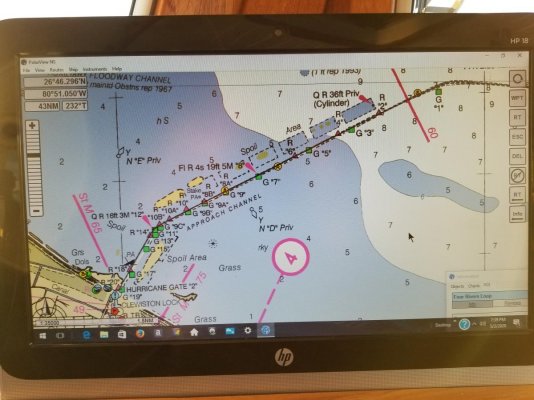
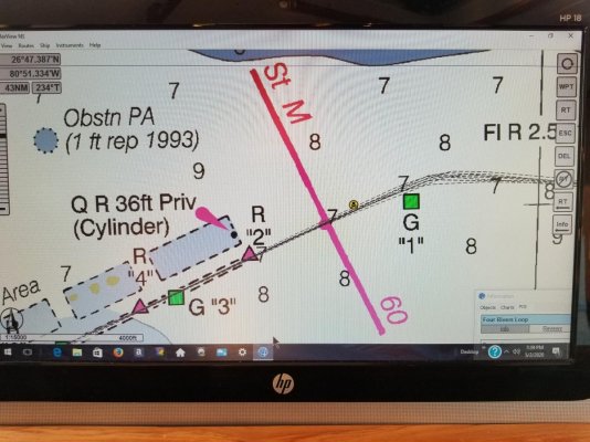
So where are the shallow spots? Coming out from Clewiston, the route takes a couple of turns before you're crossing the lake. The shallowest spot is between day marks "G1" and "R2". There is a hazard mark on the below chart that's sort of close. It goes shallower than 8' , hits 6.9' briefly, before getting deeper.

This is for general reference:
20200502_193149.jpg

You can clearly see the day marks and the hazzard symbol:
20200502_193241.jpg

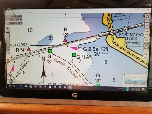
The other spot it gets shallow is just before you go between the fenders at the Port Mayaca lock. Shallowest depth I saw was 7.3'. You can see my cursor pointer marking the spot just before the fenders. Remember, there is an obstruction on the North side of the channel as you approach the fenders. You need to be 75% of the way or more, over to the Green markers on the South side from "G5" until you go between the fenders.
20200502_193348.jpg

There is plenty of water from Fort Myers to the Moore Haven lock and from the Port Mayaca lock to Stuart.

Lots of manatees in and around the Franklin lock.

Ted
 
Last edited:
So I'm heading North from Fort Myers to Chesapeake Bay. The lake is pretty low, but what's the depth you're likely to see?

A friend on TF asked me to let him know what depths I saw. So I figured there were probably some other people that would be interested and would like to see how it compares to the Army Corps of Engineers advertised depth.

So before I start, here are the disclaimers. I have always assumed there was a safety factor in what the Corps advertised. If they said it's 10', I'm assuming it has to be higher than that for liability purposes. Secondly, things change. Sand and mud move. So what it is today will likely be different after the next hurricane.

My boat has 3 transducers (OCD, whatever) and numerous displays that have been zeroed. My depth is measured in feet and tenths of feet (not inches). While I consider the depth measurements to be accurate, they're clearly not up to the standard of the Corps that measures depth to 1/100th of an inch. :confused: Also, you might not go where I went. Finally, if you hadn't come you wouldn't be here, and around every silver lining, there's a dark cloud. :rolleyes:

Yesterday's depth according to the Army Corps of Engineers was 5.38 feet.

The shallowest depth I registered was 6.9' for a fraction of a second. Most was deeper than 8'. About 3 minutes were between 8' and 7'.

So where are the shallow spots? Patience. ;)

Coming from Moore Haven, down the canal to Clewiston, I didn't see less than 8.4'. This assumes you stay in the middle for the upper third of the canal. When the canal widens, stay in the middle third of the width, favoring the West side. On the upper part of the canal, there are some curves. Assume the inside of the curve is shoal and stay off the inside by 2/3 of the width. Hope you got that, because I have no idea what I just typed. :rolleyes:

So where are the shallow spots? Coming out from Clewiston, the route takes a couple of turns before your crossing the lake. The shallowest spot is between day marks "G1" and "R2". There is a hazard mark on the below chart that's sort of close. It goes shallower than 8' , hits 6.9' briefly, before getting deeper.

This is for general reference:
View attachment 102143

You can clearly see the day marks and the hazzard symbol:
View attachment 102144

The other spot it gets shallow is just before you go between the fenders at the Port Mayaca lock. Shallowest depth I saw was 7.3'. You can see my cursor pointer marking the spot just before the fenders. Remember, there is an obstruction on the North side of the channel as you approach the fenders. You need to be 75% of the way or more, over to the Green markers on the South side from "G5" until you go between the fenders.

View attachment 102145

There is plenty of water from Fort Myers to the Moore Haven lock and from the Port Mayaca lock to Stuart.

Lots of manatees in and around the Franklin lock.

Ted

The Army Corps numbers are based on the most shallow spots of the marked channels. Clearly then that would indicate that if you found the deepest areas of the channel throughout you'd have more clearance. You could have likely varied your path at various points, still been in the channel, not stayed 2/3 from the turn or 75% of the way over. They're intentionally not quoted based on the most perfect route but based on less than perfect.
 
Thanks Ted! Well timed!
Now, can you tell me how to tie to a pair of dolphins?
 
The Army Corps numbers are based on the most shallow spots of the marked channels. Clearly then that would indicate that if you found the deepest areas of the channel throughout you'd have more clearance. You could have likely varied your path at various points, still been in the channel, not stayed 2/3 from the turn or 75% of the way over. They're intentionally not quoted based on the most perfect route but based on less than perfect.
If that's true, it's ridiculous!

Don't know what chart you think they're using, but you might want to look at the dates for the last depth soundings.

For the record, I'm on or close to the Magenta line, except as noted. Can't imagine why the Corps would use anything other than the Magenta line for the shallowest depth.

Ted
 
Thanks Ted, excellent report. We will cross Wednesday. Maybe our paths will cross on the way north. I will stalk you on Marine Traffic.
 
The Army Corps numbers are based on the most shallow spots of the marked channels. Clearly then that would indicate that if you found the deepest areas of the channel throughout you'd have more clearance. You could have likely varied your path at various points, still been in the channel, not stayed 2/3 from the turn or 75% of the way over. They're intentionally not quoted based on the most perfect route but based on less than perfect.
That's an interesting theory. When do you thing the Corp last surveyed the Route?
 
That's an interesting theory. When do you thing the Corp last surveyed the Route?

I have no idea when they last surveyed the entire route. I know they'd done spots at different times which has led to dredging.
 
Interesting Ted.

We are thinking of going the other way next month if things open up. South West plus Dry Tortugas.

What's your target for going through JAX.
 
When the water was a bit higher I destroyed two wheels by drifting a little to the side thinking the canal between Roland Martin's and Moore Haven was wider.

There was a pretty good limerock shelf
 
Interesting Ted.

We are thinking of going the other way next month if things open up. South West plus Dry Tortugas.

What's your target for going through JAX.

Probably Thursday or Friday depending on weather.

Ted
 
Probably Thursday or Friday depending on weather.

Ted

Are you planning on stopping in the area?

I think our transient is $1.25pf plus tax, power and water included. :)

No loo though, and you have to come through a lock!
 
Last edited:
5/6 crossing. Nav level 5.27' . My observations were similar to Ted's. I expected to see the low spot between 5&6 out of Clewiston but staying on the green 3rd kept depth around 7 feet. My experience from there out to the lake was different. I saw a lot of 5.5 to 6 foot until we hit the deeper water out in the lake. My new limit is 11 foot for lake level when crossing. Not fun staring at the depth sounder for so long.
We saw at least 50 gators from Moore Haven to Clewiston, mating season.
 
I know so many people who have strayed out of the channel and ruined inboard props, that we won't even go across any more. I'd rather take the time to go around, than replace my running gear.

The last guy I knew who did it, had never crossed on it, and I begged him not to do it on his way to the Bahamas. It was not a fun "I told you so" moment, when he told me what had happened.
 
Very interesting, Ted - thanks for the detailed pilotage notes. Mark Twain would be impressed.

The Lake certainly has earned a fearsome reputation over the years. Years ago I knew of a Texas-based Hatteras MY whose paid captain, obviously with zero local knowledge, tried to cross straight from Moore Haven to Port Mayaca. Didn't get far before opening up the hull on a submerged stump, and sunk it on the spot.
 
Don't know what to say, ran that stretch with my normal track down the general center of the aids to navigation, never saw those depths and my alarm was set for 6.5'. :confused:

Ted
Well clearly Ted your instrumentation is wrong and mine is right[emoji12].
No.... wait a minute. No one on this forum will believe that after viewing the rebuild of your boat.[emoji32]
My soundings are obviously hoses up. Either way it gives others a benchmark. I will still keep my 11 foot go-to limit.

Is that 11' lake level or Navigation depth? Doubt you will ever see a navigation level of 11' (lake level of 17') again.

Ted
 
Is that 11' lake level or Navigation depth? Doubt you will ever see a navigation level of 11' (lake level of 17') again.

Ted

12' lake level is our minimum but then we have a 5' draft in any boat we go through in.
 
Yep lake level
 
Yep lake level

Ok, had to go back and reread what you wrote earlier, misunderstood what you wrote.

11' lake level (5' navigation route 1) would probably be my limit. I draw 4.5', but my prop is 1' above the bottom of the skeg.

Ted
 
Ok, had to go back and reread what you wrote earlier, misunderstood what you wrote.

11' lake level (5' navigation route 1) would probably be my limit. I draw 4.5', but my prop is 1' above the bottom of the skeg.

Ted
My prop is one inch above my keel. [emoji33]
 
Darn, Ted, wish you'd done this around 3 April when we were making the decision to round Florida with our 5.5-foot delivery draft!:banghead:
 
Darn, Ted, wish you'd done this around 3 April when we were making the decision to round Florida with our 5.5-foot delivery draft!:banghead:

Tough call. You draw a foot more than my boat and the Lake was only 3" deeper. Your draft would have been equal to the navigation depth for route 1. But then, nothing parties like somebody else's boat. :speed boat:

Ted
 
Tough call. You draw a foot more than my boat and the Lake was only 3" deeper. Your draft would have been equal to the navigation depth for route 1. But then, nothing parties like somebody else's boat. :speed boat:

Ted

Yeah, I wasn't willing to put my friend's boat in jeopardy or to remain stuck in the lake until the next flood. My own boat? Oh, maybe.....Nah.
 
The Lake O depth is controlled by the channel at Clewiston leading to/from the lake. The lake itself is no problem.
 

Latest posts

Back
Top Bottom