Navionics wrong in Whitsundays

The friendliest place on the web for anyone who enjoys boating.
If you have answers, please help by responding to the unanswered posts.

Hickers

Senior Member
Joined
Feb 6, 2014
Messages
150
Location
Australia
Vessel Name
Bluechip 3
Vessel Make
Clipper 45
We watched two yachts in succession bump into the fringing reef in Macona yesterday evening though we did try to wave them off. The first one tried anchoring only to swing over the reef whilst the second sailed past them as they tried to extricate themselves and ran into the reef.
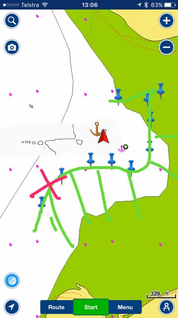
It was late in the day so hard to see against the setting sun and the navionics chart is very inaccurate.
The attached chart shows the maps reefline plus the actual I mapped out in the tinny. X marks where they both hit. No major damage seemed to be done but shows the challenge in anchoring late in the day in unfamiliar locations.
IMG_1838.JPG
 
As you move more into Asia Navionics charts have numerous issues, and if trying to use instead of common navigation expertise you will end up on the bricks!!

It amazes me as i watch more and more Electronic sailors come to grief and then blame the Navionics , where have all the real sailors gone!!!!!

Cheers Steve
 
Thanks for that heads up Hickers. Does underline the point that GPS nav and mapping should always be backed up with the latest oceanographic charts or at least local cruising guide charts, drawn up using local knowledge. Eg, the excellent Beacon to Beacon guide for use here in Moreton Bay and surroundings. I'm sure the Whitsundays would have an equivalent..?
 
I know that spot you highlighted. I was there last year in a northerly, hanging back towards your mapped area, stern not too far off the reef with boats either side, similarly with their stern's not far off the reef. I couldn't believe it when later on in the day this dude in a sailing cat motors behind us all at about 10 kn. With your info I now suspect he was using Navionics charts and likely believed he had a lot of room. He did not hit - blessing of shallow draft, high tide and a lot of luck I think.

I use C-map charts, which are less definitive than your image as far as reefline is concerned, likely a good thing as it encourages more caution. I like high sun-angles when looking to anchor in those places, and wear polarising sunnies up on the flybridge. Then its real easy to see the reef! Its not for nothing that the charter companies require people to be anchored early!
 
Thanks for that heads up Hickers. Does underline the point that GPS nav and mapping should always be backed up with the latest oceanographic charts or at least local cruising guide charts, drawn up using local knowledge. Eg, the excellent Beacon to Beacon guide for use here in Moreton Bay and surroundings. I'm sure the Whitsundays would have an equivalent..?

This is the local 'bible'
https://100magicmiles.com/product/1...barrier-reef-whitsunday-islands-11th-edition/

I just checked my copy, it has an accurate map of the fringing reef in Macona Inlet.
 
Last edited:
Yep, I know that precise spot as well. That is quite a solid, well defined bit of reef - must have given both of those skippers quite a fright!

The reef is quite visible in the middle of the day when wearing polarising sunnies, as Brian says. And at low tide it is so shallow it is hard to get a kayak over it.

Just goes to prove the old rule - dont move around and try to anchor in those places with reef late in the day or after dark.

H.
 
Hickers, great that you marked the reef on your chart. From the icons it looks like you marked it on your chart on your plotter, but did not use Community Edits function so that other boaters that use Navionics get the update as well. If you click on the chart and select Edit Map it will edit and then the data will be uploaded to the Navionics servers so other boaters can use that very valuable information. If you tell me what unit you are using (or app on your phone/tablet?) I can give you more detailed I structions of how to do this.
 
unfortunately, Navionics is no better in lots of other places. I have witnessed two places quite close to my home, where the charted reefs are dangerously out of position. The first led to a thread I posted on TF shortly after the July long weekend in 2016. I happened upon a large sailboat hung up high on a reef near Gabriola Passage, Canadian Gulf Islands. When I went back to chart the reef properly I found that on the Navionics, the position of the reef was out by close to 100 ft, showing white, therefore safe passage, where it should have been green.
Always be cautious, but especially when reliant upon Navionics for position information.
 
Back
Top Bottom