You are using an out of date browser. It may not display this or other websites correctly.
You should upgrade or use an alternative browser.
You should upgrade or use an alternative browser.
Paper charts survey
- Thread starter Capecodder
- Start date
The friendliest place on the web for anyone who enjoys boating.
If you have answers, please help by responding to the unanswered posts.
If you have answers, please help by responding to the unanswered posts.
78puget-trawler
Guru
Tried to leave a comment but didn't appear to work. Clicked on submit, nothing happened. Good grief.
OldDan1943
Guru
- Joined
- Oct 2, 2017
- Messages
- 10,656
- Location
- USA
- Vessel Name
- Kinja
- Vessel Make
- American Tug 34 #116 2008
I'd sure feel better having paper to rely on.
Because of Russia's demonstrated ability to disrupt the GPS system, reliable current, paper charts are almost a necessity.
I understand the US Navy is teaching how to use a sextant again.
Codger2
Guru
- Joined
- Oct 11, 2007
- Messages
- 6,691
- Location
- US
- Vessel Name
- Circuit Breaker
- Vessel Make
- 2021..22' Duffy Cuddy cabin
I like both electronic and paper!
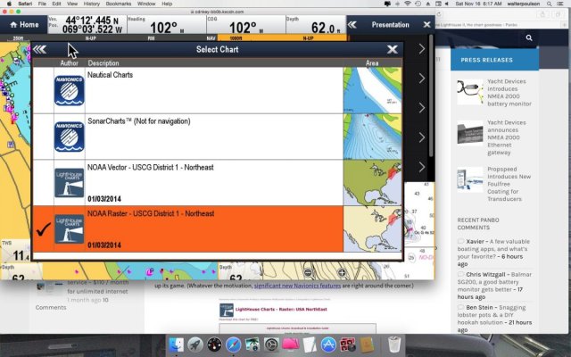
Raymarine's eS127 & 128 came with several different types of charts. Navionics, C-map & Lighthouse. Lighthouse charts are raster scanned directly off the NOA paper charts and have a lot more detail than most electronic charts. I'll admit, however, to using Navionics the most as the "Auto Routing" feature is fantastic!
Updates can be loaded directly from the Internet to the MFD and are free!
Chart selection (C-map is also included when scrolled down.)
Attachments
Last edited:
psneeld
Guru
Computerized charts have NO connection to GPS...they are often just a "scan" of a paper chart loaded into a reading device (phone, tablet, computer) or a collection of data points and read on a screen, instead of being printed on paper.
Only the nav portion of a chartplotter is affected by GPS loss...NOT chart reading or piloting actions.
Yes many will be lost when and if GPS is disrupted...but IT HAS NO BEARING ON whether you use paper or electronic charts.
Only the nav portion of a chartplotter is affected by GPS loss...NOT chart reading or piloting actions.
Yes many will be lost when and if GPS is disrupted...but IT HAS NO BEARING ON whether you use paper or electronic charts.
caltexflanc
Guru
Because of Russia's demonstrated ability to disrupt the GPS system,
Oh so that's whose fault this was....
Back on topic, while I bemoan the move from paper by NOAA, their new Custom Chart function looks very cool, and will allow private paper chart publishers and end users to do create some very location specific things.
Last edited:
ben2go
Guru
Eggsalad point there.Computerized charts have NO connection to GPS...they are often just a "scan" of a paper chart loaded into a reading device (phone, tablet, computer) or a collection of data points and read on a screen, instead of being printed on paper.
Only the nav portion of a chartplotter is affected by GPS loss...NOT chart reading or piloting actions.
Yes many will be lost when and if GPS is disrupted...but IT HAS NO BEARING ON whether you use paper or electronic charts.
ben2go
Guru
:lol: Excellent point.Eggsalad point?
OK...think I get it.
I keep a set of Maptech waterproof charts on board. I take a peek at then occasionally to get the big picture during trip planning. Have never needed them for navigation. If some country brings down our gps, we won't be worrying about current charts.
Similar threads
- Replies
- 97
- Views
- 4K
- Poll
- Replies
- 89
- Views
- 4K
Latest posts
-
-
-
-
-
-
Boat issues found after the survey and deal closed
- Latest: CP Edmunds
-
-
-


