Will my autopilot follow waypoints from Navionics on my iPad?

The friendliest place on the web for anyone who enjoys boating.
If you have answers, please help by responding to the unanswered posts.
Joined
Jul 3, 2016
Messages
1,541
Location
Sandusky Bay
Vessel Name
Escape
Vessel Make
Mariner 37
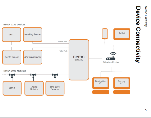
We still have a few years until we are putting in serious distances. Until then, I am happy with the job Navionics does running on an iPad. We have redundancy with a second iPad or smart phones when needed. When the time comes, my plan is to reconsider the state of the electronic navigation market and then make the smart decision. Guessing it will be a MFD with the usual items running on a NMEA 2000 network and a WiFi gateway to enable the tablet to be used in a route planning or casual way.

In the meantime, I would like to explore the possibility of getting our old Simrad AP16 autopilot to follow a route of waypoints from Navionics. Since I don't find a lot of write ups on it, I am guessing that today's WiFi gateways or other connectivity for the iPad do not permit the AP16 to receive the heading commands from Navionics.

Seems like this should not be an uncommon objective. What am I missing? I get that the wireless connection may not be robust enough to depend on for long passages or tight traffic areas. I always hand steer in heavy traffic or tight channels, and never trust the autopilot to take the place of my attention at the helm. Still, it would be nice to have it follow a simple set of waypoints. Anyone doing that?
 
That's an interesting idea. I did a bit of searching. It seems that is not possible with Navionics. Some of the references I found are as recent as November 2022. I did dig around in Navionics menus and found no options or settings that tell me Navionics is able to output autopilot NMEA sentences. For the definitive answer contact Garmin.

I'm not an iPad user but I can guess there are other apps that will output autopilot sentences.

Then there's getting the iPad connected to your autopilot.
 
I know Navionics can receive NMEA 2000 sentences ousing a Gateway like the NEMO and a wireless access point, but as previously stated I don’t know if it will transmit AP sentences.

Tom
 
Old video but might be of some help. Since this video is so old I'm sure that there have been improvements.

Wow, 11 years is a long time, especially in the technology space. I was surprised to learn that Navionics has been around that long. Turns out it's been around a lot longer than that having started in 1984. I remember computing and "displays" in 1984. Must've been a rocky start!

Anyway, while that is encouraging, I am surprised that aspect of the marine navigation industry has not become more prevalent. Tablets are ubiquitous now, as are local WiFi networks. Virtually every boat in this group has an autopilot. Surely I am not alone in wanting the two to talk?

There are regular conversations about Loopers navigating thousands of miles with nothing more than Navionics running on a tablet. There are also regular conversations about new owners discovering that their electronics are outdated. Again, I appreciate that one should not depend on WiFi connections for critical navigation, but many (most?) Looper types do the critical navigation manually and rely on their autopilot for crossing Great Lakes or other open stretches. Seems like a wildly underserved market.
 
It seems the show stopper for your plan is Navionics. It just doesn't output NMEA autopilot sentences. You'll have to find another app that does output NMEA autopilot sentences. Not being an iPad user I can't make any recommendations. The video up thread demonstrates iNavx which I think is still around.

Once you find an app you are comfortable with and has the capability to output NMEA autopilot sentences it looks like you'll have to roll your own. I think it's possible it just going to take some research and a bit of trial and error.

Because tablets are designed for WiFi network not hard wired I/O you will need to use wireless communication. That starts with a wireless router. Then add a mutiplexer to communicate with your autopilot.

Rather than the older multiplexer in the video I'd lean towards something newer, maybe look at Rose Point's Nemo Gateway. There are others on the market. Maybe someone here more network savvy that I can recommend one. No matter which mux you choose Nemo has an easy to understand one-line diagram for the basic layout of connecting to a tablet.

The one-line attached here does not specifically show an autopilot. In NMEA 0183 terms the autopilot is a listener. The one-line does show listeners. Further down the manual is discussion about hooking up listeners. Rose Point Gateway User Manual

I do recommend that you go NMEA 0183 for this effort unless you are familiar with NMEA 2000 networks. The basic setup you are looking for is oneway comms tablet to autopilot, NMEA 2000 is more than you need for this project. And it's likely your Simrad AP16 won't listen to NMEA 2000. Time spent with the AP16's manual will tell you if I'm right about this.

I have never tried anything like what you are attempting to do so may have some of the concepts wrong. But it does look like it's possible. Might even be fun to try to figure it out.
 

Attachments

  • Nemo.png
    Nemo.png
    55.9 KB · Views: 48
Coastal Explorer for the IPad can control an AP over a wireless network using a gateway like the NEMO.
 
I just searched for iPad serial adapter. Lots of options. You might find one that goes straight from the iPad hard wired to the autopilot.


For some reason this little puzzle interests me. Can't explain it. I'm not an iPad user and won't use Navionics for important navigation. Maybe as I dig around I'll learn something to go from OpenCPN on Android to Simrad AP26. Could be an OK backup.
 
It seems the show stopper for your plan is Navionics. It just doesn't output NMEA autopilot sentences. You'll have to find another app that does output NMEA autopilot sentences.

Ah-hah! That makes sense. Navionics seems like it's everywhere in boating, including in this more serious trawler segment, and it does so many of the same things other chart plotters do. It made sense that Navionics put out NMEA autopilot sentences just like other chart plotters. I know what happens when you assume, but I still fell into that trap.

Coastal Explorer for the IPad can control an AP over a wireless network using a gateway like the NEMO.

I have looked at CE, but the main differences between it and Navionics seemed like complexity features I was not after. It's clearly time to re-evaluate that.

I just searched for iPad serial adapter. Lots of options. You might find one that goes straight from the iPad hard wired to the autopilot.

I have been using Apple products since 1986 and proprietary is a common theme. Where PCs and Android tablets seem to use serial connections, Apple generally makes it difficult to use the obvious.

That said, a hard wired serial connection between the iPad and the NMEA network to the autopilot would fix some of the consistency issues of WiFi. Of the ones I looked in to, they generally work with one version of connector and not the others, and often one operating system version and not the others. Apple makes it hard on developers.
 
I think there are handful of issues in the way of doing what you want.


First, I don't think the Navionics App is a talker, rather only a listener. So even if you provide a way for it to communicated back to the AP16, it's mute.


Second, the various wifi gateways I believe also all just "talk" over wifi, and don't listen.


To work, I think you need a proprietary connection/protocol between the plotter app and some gateway that can also speak N2K and/or 0183. Coastal Explorer + Nemo does that. Some of the single-vendor apps probably do too.
 
Apple makes it hard on developers.
And challenging for users with their proprietary hardware / software and hiding thinge behind the secret curtian. I gave up on Apple long ago for those reasons. But it seems Windows and Android are begining to play the same games.
 
I think there are handful of issues in the way of doing what you want.


First, I don't think the Navionics App is a talker, rather only a listener. So even if you provide a way for it to communicated back to the AP16, it's mute.


Second, the various wifi gateways I believe also all just "talk" over wifi, and don't listen.


To work, I think you need a proprietary connection/protocol between the plotter app and some gateway that can also speak N2K and/or 0183. Coastal Explorer + Nemo does that. Some of the single-vendor apps probably do too.

Those two items are the answer to "What am I missing." Thanks guys.
 
I was all ready to say that we have a winner. Then I looked at the Rose Point website and say this. While the article is dated it doesn't indicate what year. Hopefully this has been resolved. https://community.rosepoint.com/t/we-are-removing-coastal-explorer-from-the-app-store/879
I've used Coastal Explorer on my laptop and it's great. Rose Point is also really helpful if you have a problem.
If they've resolved their issue with the app I'd I'd be back to saying that we found the winner

Coastal Explorer for the IPad can control an AP over a wireless network using a gateway like the NEMO.
 
The way we use the iPad is to plan a route using Navionics then export the GPX file to an SD card. Put the card in our Lowrance HDS Gen 2 plotter and import the route into Navionics on the plotter. The only issue I've had is that I have to email the gpx file otherwise the plotter won't recognize it. If you have a chartplotter connected to your network this should work for you. The plotter could then send the route to the autopilot even over 0183.

James
 
I am (slowly) coming around to the fact that Navionics on a tablet is more of a convenience item than an integral part of navigating the boat. I thought it could do both, but it can't for a few key reasons.

That leaves me between a dedicated chartplotter or MFD that works and plays well with Navionics (like a Garmin), or a more home brewed solution like Coastal Explorer running on a dedicated computer. Either will talk to the autopilot and either will accept routes exported from Navionics running on an iPad.

At the moment, the new sync and layers features of Coastal Explorer make it sound easier, especially if one uses their iOS CE app instead of Navionics. No exporting. Routes created on the iPad simply appear on your CE system via the cloud account.
 
Last edited:
Do you have any chart plotter connected to your autopilot currently? Navionics works well on our 10 year old Lowrance Gen 2 touch device. Or is your autopilot a stand alone device?

James
 
We had a pair of Standard Horizons units that felt (at the time) to be obsolete or at least too hard to work with. In hindsight, the CPV350 at the lower helm was pretty handy and getting it networked to the autopilot would not have been that difficult. Importing routes from Navionics was rather involved though. That and the grass looked much greener on tablet solution side. As is often the case, the grass is not greener.
 
I think the IPad problem you saw referenced on the Rosepoint web site was corrected the next month by a new IOS release.
 
I looked for Coastal Explorer on the iOS App Store and it was still not there. Rosepoint still has the "temporarily removed" statement on their website too.

https://www.rosepoint.com/coastal-explorer/ipad

Another option has emerged (at least to me; it has been around for a few years) in iNavX. It solves the Navionics and WiFi gateway issues. The iNavX app does publish NMEA autopilot sentences and their gateway does listen instead of just talking.

As with most things, there are compromises. Navionics has a more refined and user friendly interface where iNavX offers more flexibility and customization. C'mon, Garmin. Get in the NMEA game!
 
Have friends who have gone RTW with no chart plotter and just several iPads augmented with single function (AIS, radar, depth, speed, wind etc.) small screens. No network, no backbone and a completely autonomous AP. Each leg put in manually. Their argument beyond limiting expense is when they lose one thing they lose one thing.
I’ve never gone to that extreme but think there’s a strong argument to make in avoiding having the AP follow a string of waypoints. Yes I might put in autoroute but even then think it’s much safer to look at each leg and manually put it that leg. More than once I’ve disagreed with autoroute. More than once situation at that moment suggests changing course put in due to local factors. Drift, set, traffic, better ride due wave train, even view outside may enter in to it. It takes a second or three to twist the knob or push the button. On our recent journey from RI to SC although available we didn’t once have the AP follow a string of waypoints although that capability was there.

So one could argue having you manually transfer a course from a tablet with navionics to a stand alone AP isn’t a burden and may increase your safety.
 
Last edited:
I no longer let my navigation software send instructions to my autopilot. For me it just seams less efficient than letting the autopilot head for the next way point while making a few adjustments along the way.

When I brought the boat up from LA I had an autopilot and an IPad. It worked fine. I adjusted course far more often to avoid obstacles than correcting heading. I eventually came to the conclusion that manually operating the autopilot was more convenient.

Once In the PNW I installed new electronics. For a while I would let the chart plotter control the autopilot. Sounds cool, leave the harbor, punch a button and the boat drives it’s self to the desired destination. Reality is always different. It just became more work to dodge obstacles. I also got tired of all the squealing at every waypoint.

I just don’t see it as very important to have Navionics on an IPad giving commands to an autopilot.

Matches my thoughts and experience exactly. Look at bearing to next mark, course made good, and adjust AP accordingly. Situational awareness is always your best aid to navigation.
 
This is an interesting discussion. I was pretty stoked when I got a simple Raymarine MFD interfaced to my EV1 AP and watched it automatically course correct for wind/current. Our passages are typically 10-14hrs straight in one direction. This "feature" makes the passage even more boring, and even with everything from a single manufacturer I've encountered some bugs & spent a fair amount of time troubleshooting now that I have 2 MFDs. My AP is now less reliable than it was when I was using an iPad and just relying on the AP to follow a heading.

I'm not sure I'd disable the capability but there's something to be said for keeping things simple & independent.
 
I’ve been sending routes to my Raymarine AP pretty much all the time from Coastal Explorer over the last few years. The main reason is compensating for tides and wind. By using routes, I can focus on other things such as obstacles, whales, debris in the water, other vessels, and in marginal visibility, the radar. I find it especially useful in narrow passages where the channel is only 20-30 ft wide and a precise course is necessary. Because these channels typically have 1-2 knots of current that swirls in places, I find the AP drives a much straighter line than I could hand steering and allows me to focus on the sounder and planning for the next turn. I’ve been through Rocky Pass south of Kake more than a dozen times using this method and it is now almost a routine passage except for two places where my finger is on the standby button.
 
.............................

I just don’t see it as very important to have Navionics on an IPad giving commands to an autopilot.

Matches my thoughts and experience exactly. Look at bearing to next mark, course made good, and adjust AP accordingly. Situational awareness is always your best aid to navigation.

Agree. :thumb:
AI one day will take over, but not today.
 
There are two camps on electronics.

Minimalists, usually an iPad or phone with Navionics and those who want a full suite of same brand integrated electronics.

One is cheaper and does get the job done. The other gives more options which equates to better safety.

Neither is the answer for all.
 
For sure though to me it looks more like a continuum with those as extremes. As they say, we all have opinions.

I already fall into a camp on this subject. For the next couple (few?) seasons, I expect to be at that minimalist end being happy with Navionics running on an iPad and my AP16 getting manual heading instructions from me. At some point we expect to strike off over the horizon and at that time I expect to want/need a more robust solution. I want my AP16 to receive heading commands from my navigation software. Not in marinas or heavy traffic or during tight maneuvers, but when in open water with few obstacles.

I see three likely outcomes at this point (in order of cost and complexity), but the relentless march of technology is sure to present more in the coming years.

  1. Learn to use iNavX, buy their WiFi gizmo, and connect it to my NMEA network
  2. Learn to use Garmin, buy their WiFi gizmo, buy a lightly used Garmin chartplotter, and connect it to my NMEA network
  3. Learn Coastal Explorer, buy their WiFi gizmo, buy a 12 VDC PC and monitor, and connect it to my NMEA network
 
As mentioned earlier I did a 1200 mile coastal run with an IPad and an autopilot. I also did a run to ‘Alaska with Coastal Explorer on a laptop that used a serial port to send 0183 to my autopilot. I had a stand alone radar on that trip. Now I have a complete Raymarine system with overlay.

All 3 systems worked well. I love having Coastal Explorer as my backup and my only reason for not making it my primary system is my experience with windows locking up at the wrong moment. I really liked running Coastal Explorer on a 24” monitor, as a plotter it has more features than any other system I have experienced. I can think of no cheaper way to have a large screen chart plotter. I was never uncomfortable using Coastal Explorer as my primary, I simply found it easier to turn on a dedicated system. Using Coastal Explorer with an IPad back up souNDS like a great system to me.

The next time I make a big Coastal Cruise I will most likely be running all three systems at once. Partially for the entertainment and partially for safety, mostly for entertainment.
 
I did a stint in the Microsoft world during the Windows XP to Windows 7 era and know what you mean about locking up at the wrong time. Sad how little Microsoft has done with the amazing advancements handed them by the hardware folks.

Anyhoo, it seems like the most reliable approach, assuming the desire is for the autopilot to follow a route of waypoints, is the dedicated chartplotter talking to the autopilot. No Windows crashes and no WiFi dropping out, but you still have the flexibility of running Navionics or some other app on a tablet that can export routes to the chartplotter. At least for me, and at least for now.
 
Back
Top Bottom