Would you go with 3 feet of clearance?

The friendliest place on the web for anyone who enjoys boating.
If you have answers, please help by responding to the unanswered posts.

huruta

Senior Member
Joined
Jan 9, 2022
Messages
111
Vessel Make
2006 Nordic Tug 32
Hey. We are relatively new to boating, ~1 year in. We were out last week considering heading up to Marrowstone island in WA. There are pretty big tide shifts in the past few weeks. Based on our review for the period we'd be there was a lowest tide of 0.89 feet and high of ~12 feet. Our Waggoner guide said at 0 tide, the marina was 6 feet deep. Our Nordic has a draft of 4 feet.

Would you have gone? We would have had 2.89 feet of clearance (estimated). We didn't go, but we aren't sure what the threshold should be. How much error is there in published estimates? How do you navigate these kinds of decisions? Also, the only guide we had for the depth at 0 tide was information in the Waggoner guide - where do we get information about how deep an area is at 0 tide?

Probably rookie questions, but would rather look stupid here than on the water with a beached boat!
 
With a Nordic Tug with a keel and protected prop, I'd go. I'd assume there are many boats in the marina. Of course, keep an eye on depth gauge and any local information including temporary buoys and such. Also want to go on a rising tide so if you do get jammed, you can float off soon.

You can also call the marina. They often have guidance on what side of channel to favor.

Good luck.

Peter
 
A great deal depends on current and bottom composition. I have gone into a number of places with a sand or mud bottom with less than a foot to spare. This works if you can creep in slowly and back out if you bump. Not interested in doing it on rocks or against a current. The other option is to enter on a rising tide and decide if you'll have enough water when the tide goes out. In your scenario I would probably have gone and then decided if I felt comfortable staying at low tide. It's always good to have a viable plan "B" before committing.

Ted
 
The place he is considering has no marina, at least none I've seen. There is an entrance bar and then a rather circuitous, though adequately marked, channel through a very shallow bay. I've taken a dinghy in there a couple times, but the real question would be "why?". In the words of Gertrude Stein, " there is no there there." Unless, of course, you count the nuclear munitions stockpiled on the unapproachable western shore.
 
Last edited:
Many interesting locations in the vicinity. Some with facilities, some offering solitude...
 
Appreciate the responses. Not really a marina, more a park dock. Called the park Ranger who was clueless. Why there? We’ll we want solitude and liked it when we went there to camp. Would guess there are some rocks there, hence the interest in range of error in published info, and how do we figure out depth at 0 tide to put negative tides in context? Thx!

How do we figu
 
Keep in mind the charts and guidebooks reference Mean Lower Low Water (MLLW) so a negative tide would be subtracted. Port Townsend had a -3.7 on the 4th of July.

You could go in on a high tide but then your stuck until you can get back out.

Finally, even if you clear the bottom, sucking up mud, grass, gunk into your engine intakes at low low tide isn’t fun.

Terrific that you’re asking. Lots of boats high and dry around Puget Sound last week.
 
Yeah, saw pics of many of those stranded. Definitely want to avoid that. So, a -3.7 tide….how do we know what to subtract the 3.7 from? The only reason we had the 6 foot reference was because it was in our Waggoner guide.
 
Yeah, saw pics of many of those stranded.


If you must... let us know how it turns out. (not kiddin' about the nukes.):socool:
 

Attachments

  • MARROWSTONE.JPG
    MARROWSTONE.JPG
    75.6 KB · Views: 64
Last edited:
And post photos of the boat sitting on the bottom…. Just kidding.
 
Yeah, saw pics of many of those stranded. Definitely want to avoid that. So, a -3.7 tide….how do we know what to subtract the 3.7 from? The only reason we had the 6 foot reference was because it was in our Waggoner guide.

Don’t second guess your self. You are new to this and with experience you will have a better understanding of how far you can push things. Going because some one else said it was ok is the wrong move.

A year from now you might think you were too conservative but a year from now you will be more experienced.
 
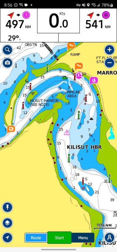
Navionics is likely much more up to date than the raster screenshot. Shows a decent entrance. Surprisingly, no active captain reports

Maybe I'm jaded by living in Florida with nothing but skinny water. Rising tide, decent weather. Slow bells. Standard precautions. Maybe go on a Saturday when likely more boats in and out.

Peter Screenshot_20230707_205652_Boating.jpg
 
To bring some perspective, there are times we will have only 6" ( yes 1/2 ft ) of clearance under the keel of our 58 ft trawler, especially in the Bahamas, where traveling long distances with very little clearances is common.
In the ICW ( Intra Coastal Waterway ) it's WHEN you run aground instead of IF you go aground. Scary as that sounds, it happens.
Important info would be what the bottom is: sand or mud is more forgiving then rocks or coral.
In Hawaii for instance we need 10 ft or more, because it's coral down there, many time coral heads rise very quickly and can easily puncture the hull.
Good sun light and a good lookout on the bow is important.
For sure go slow, and watch your depth non stop when it gets shallow!
Finally when you hit, back off quickly and forcefully.
 
Navionics is likely much more up to date than the raster screenshot. Shows a decent entrance. Surprisingly, no active captain reports

Maybe I'm jaded by living in Florida with nothing but skinny water. Rising tide, decent weather. Slow bells. Standard precautions. Maybe go on a Saturday when likely more boats in and out.

Peter View attachment 140334

I do not think their issues was with the current. It was with the amount of water at the dock.

Yes, it looks easy on the chart and shouldn’t challenge any seasoned skipper. But, and there is often a but. The current does not follow the channel. Boats often get sucked into the shallows as the current runs straight out the northern gap. While no one needs to be afraid of this entrance, those who fail to pay attention will end up high and dry. The normal tide swing for This area is 8-10’.
 
Yeah, saw pics of many of those stranded. Definitely want to avoid that. So, a -3.7 tide….how do we know what to subtract the 3.7 from? The only reason we had the 6 foot reference was because it was in our Waggoner guide.


At a -3.7 tide, you would subtract 3.7' from EVERY depth number on the chart. That would give you the depth at the lowest water level. In the given example, at a -3.7' tide.

To answer your first question, if it were the first time into that inlet, I personally would not have gone under those conditions. YMMV:dance:
 
H,
First time, do that entrance on a rising tide.
Also, you need to know if your depth sounder is set at water level or keel depth.

I usually go down to the end at Scow Bay. Bummed that the Nordhaven store burned down, great place.

Also, stay away from shore of Indian Island. Many barges were working there wwII, bottom is foul with abandoned ground tackle.
 
Perhaps I am the only one who is worried about ‘water under the keel’ so I offset the depth sounder to reflex that, then and now. I dont want to do the math when in skinny water.
I also ‘cheat’. My boat, empty, draft 3.5ft. I call it 4ft.
 
Last edited:
You do have charts on a char plotter, right? If not, that's your first step.


To answer your question, charted depths are at mean low water, and tide levels are relative to the same MLW. So if the chart says 6', then it's 6' at MLW, less on a negative tide, but usually much more.


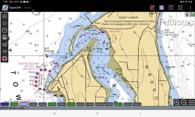
Looking at a chart of the entrance channel to Killisut Harbor, it appears well marked with a minimum depth of 9', and mostly in the teens and twenties. I would not hesitate to take my boat in with a 7.5' draft, but I would avoid transiting the channel without a little positive tide, and preferably rising if the tide is on the low side.


Once in the harbor there is plenty of depth. As for Gertrude, I have no idea what's in there are what it's like.
 
You do have charts on a char plotter, right? If not, that's your first step.

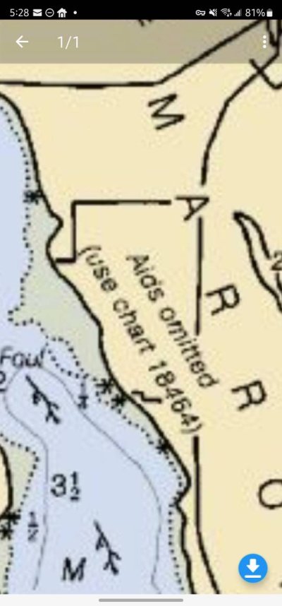
I zoomed in on the Raster in post #10 - it was so much different than the Navionics screenshot. If the Raster were ny only chart, I'd pass too. And then I saw a note that was new to me - "aids omitted. See chart 18464."

Peter


Screenshot_20230708_052830.jpg
 
I zoomed in on the Raster in post #10 - it was so much different than the Navionics screenshot. If the Raster were ny only chart, I'd pass too. And then I saw a note that was new to me - "aids omitted. See chart 18464."

Peter


View attachment 140336


Gotta look at the right chart. Also, the Raster chart depths are in Fathoms, not feet.


No offense intended, but the OP really should take a course or otherwise study up on the basics of navigation. Nobody is born knowing this stuff - we all have to start at the beginning. But if you are going to be boating, then you REALLY do need to learn it.
 
As stated above. The vertical datum for many if not most NOAA charts is MLLW. The same with NOAA's tide predictions. But you must know what both the chart and tide predictions datum are. And you must know the depth units used. In North America fathoms, feet and meters are used. As you expand your cruising grounds into Canada this requires you learn CHS standards.

Further complicating the situation is when you move from official charts by a nation's hydrographic agency to proprietary charts like Navionics. And some plotters attempt to compensate for state of tide.

Then you need to know the reference point of your sounder. Water surface? Depth under the keel? Depth under the ducer? Or?

Your question was would you go with 3 ft? My answer, and it's only valid for me, is yes. Yes but. Once I have a handle on all of the above.

Waggoner guides are good. But only a reference not a final answer.

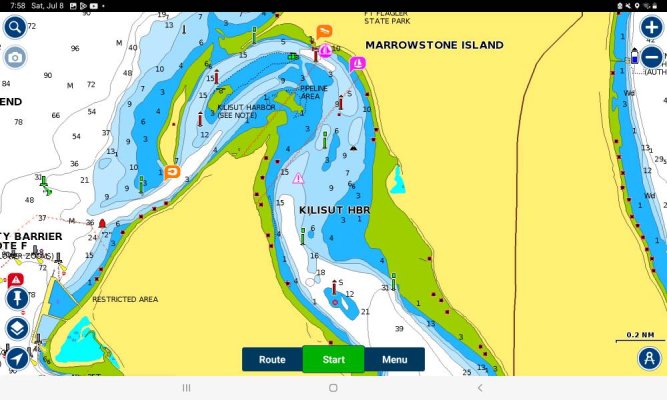
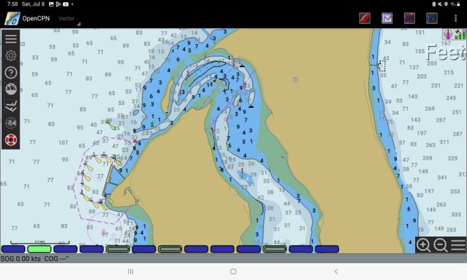
Take a look at NOAA's raster and vector charts as well as Navionics on the Boating app on Android.

Here's NOAA's explanation of tidal datums. There's a lot to learn but it's not difficult. Screenshot_20230708-075853_Boating.jpgScreenshot_20230708-075841_OpenCPN.jpgScreenshot_20230708-075812_OpenCPN.jpg
 
There is a clear path into the harbor if you follow the channel markers, that’s why they are there. If it wasn’t a well used channel there wouldn’t be markers.
Lots of boats go there every year, just use common sense. As has been mentioned more than once, go in slow on a rising tide. Watch the sounder and plotter to see if the depths align to what you think they should be.
If I’m kicking up muck from the bottom with my prop I’ll rethink proceeding.
If I have three feet under the keel I usually feel good about entering. Slowly.
 
Perhaps I am the only one who is worried about ‘water under the keel’ so I offset the depth sounder to reflex that, then and now. I dont want to do the math when in skinny water.
I also ‘cheat’. My boat, empty, draft 3.5ft. I call it 4ft.


Water under the keel is what matters, but I keep my sounder calibrated to surface depth. I know what the "this is a problem" depth is in my mind, so having it set to surface depth provides one big benefit in skinny water like that: it's easier to confirm that what I'm seeing is as expected relative to a chart, or what someone else has told me I should see for water (if I'm seeing less than someone else did a week ago, I might be in the wrong place).
 
Water under the keel is what matters, but I keep my sounder calibrated to surface depth. I know what the "this is a problem" depth is in my mind, so having it set to surface depth provides one big benefit in skinny water like that: it's easier to confirm that what I'm seeing is as expected relative to a chart, or what someone else has told me I should see for water (if I'm seeing less than someone else did a week ago, I might be in the wrong place).

I don't recall seeing a thread on setting depth to surface or offset to keel, but I'm sure there has been several. I can see the case for either but curious which direction consensus leans....

Thoughts?

Peter
 
. Our Waggoner guide said at 0 tide, the marina was 6 feet deep. Our Nordic has a draft of 4 feet.

Heck I have a 6'4" draft and go into places like there the clearance is inches and a tide of 1 foot
 
Perhaps I am the only one who is worried about ‘water under the keel’ so I offset the depth sounder to reflex that, then and now. I dont want to do the math when in skinny water.
I also ‘cheat’. My boat, empty, draft 3.5ft. I call it 4ft.

Dan, there are at least two of us that do it this way.
 
My transducer is a foot below the waterline. I draw 4-1/2 feet so I leave the offset at zero and use the 1foot as safety margin.
When my sounder reads 4-1/2 I still have a foot clearance.
 
I don't recall seeing a thread on setting depth to surface or offset to keel, but I'm sure there has been several. I can see the case for either but curious which direction consensus leans....

Thoughts?

Peter

We boat in shallow water frequently in the California Delta. We calibrate our sounder to “depth of keel”. Makes sense, to us. We don’t want to perform mental arithmetic in stressful places.
 
I don't recall seeing a thread on setting depth to surface or offset to keel, but I'm sure there has been several. I can see the case for either but curious which direction consensus leans....


Thoughts?


Peter
My recreational boating is in skinny water. Depth under the keel is what is important to me.
 

Latest posts

Back
Top Bottom