Newer Furuno Chartplotter connection to Older Raymarine Autopilot

The friendliest place on the web for anyone who enjoys boating.
If you have answers, please help by responding to the unanswered posts.

UrsusMaritimus

Veteran Member
Joined
Aug 23, 2019
Messages
43
Location
Canada
Vessel Name
Midnight Sun
Vessel Make
1985 Hershine 42 Sundeck
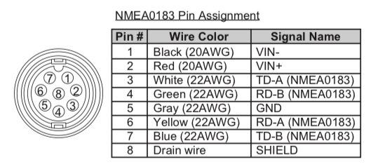
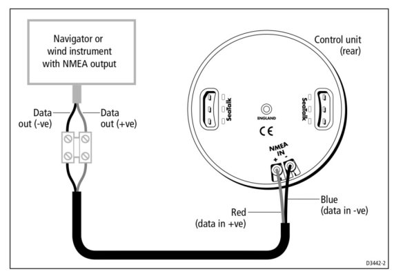
I have a Furuno, GP1971F, which has both NMEA 2000 and NMEA0183 connections. I would like to connect it to my older Raymarine S3G autopilot. The NMEA 0183 cable pin out for the Furuno, and the NMEA input for the Raymarine are attached here. I’d love some input on which two out of the Furuno cable to connect to the Raymarine.

Thanks in advance!
 

Attachments

  • IMG_1895.jpeg
    IMG_1895.jpeg
    91.8 KB · Views: 48
  • IMG_1896.jpeg
    IMG_1896.jpeg
    66.5 KB · Views: 47
Well, my local electronics guy got back to me right after I asked the hive mind here... I am told White to the positive and Blue to the negative.
 
I have a Furuno, GP1971F, which has both NMEA 2000 and NMEA0183 connections. I would like to connect it to my older Raymarine S3G autopilot.

I'm surprised by your diagram that seems to connect 0183 wires directly to what looks like the control head.

We have a new Furuno TZT3 now connected to our older Ray AP... but the 0183 wires are connected at the AP course computer (SmartPilot, in our case) and not the AP control head (ST8001+ in our case).

The back side of our control head looks like yours... but the only connection we need there is a proprietary Ray SeaTalk cable in one of the ST inlets.

-Chris
 
Hey Chris, I didn't realize this was a feature unique to the ST6001, but it is a pass through input for one 0183 device. The course computer has two 0183 connections as well. I connected it up last night, and it is receiving appropriate commands from the Furuno.
 
I have a question???

Why is it important for your autopilot to be slaved to your chartplotter?

I ask this because...

Your autopilot steers to a heading you input in the autopilot itself, and it derives that heading from it's dedicated compass.

Your chart plotter is not part of that process.

If connected to your chart plotter your autopilot can steer to a route, is that the functionality you are after??? Because that is the only real benefit, and that is in practicality somewhat limited in benefit.
That was the functionality I was after. I agree that the most useful function of the autopilot is heading hold, but I did also want it to follow a track. It’s connected now, and functions as expected.
 
Kevin,

Probably 75% of my underway time is having the autopilot follow a route. If you regularly have to deal with winds and tides, following a route lets the electronics do what they are designed to do and takes workload off the captain. With a route you can keep your eyes outside and in bad weather on other sensors.

I guess the utility of routes depends on where you are. Traveling in the inside waters of Southeast Alaska, following routes is invaluable.

Tom
 
I use my autopilot in both modes. If I am crossing a large body of water with multiple cross currents I will use the track feature. The rest of the time I just leave the autopilot on heading hold and adjust manually.

I find that the boat hunts much more in track mode than in heading hold.
 
Hey Chris, I didn't realize this was a feature unique to the ST6001, but it is a pass through input for one 0183 device. The course computer has two 0183 connections as well. I connected it up last night, and it is receiving appropriate commands from the Furuno.

Ah. If it's a pass-through, maybe it would work the same on our 8001 too. It was easy to reach wires from plotter direct to course computer, though, so did it that way (and not knowing another option might be available).

-Chris
 
Last edited:
Dang it, wish I'd known about the NMEA0183 pass through option on the ST6001, that would have made my wiring so much easier...
 
I have a question???

Why is it important for your autopilot to be slaved to your chartplotter?

I ask this because...

Your autopilot steers to a heading you input in the autopilot itself, and it derives that heading from it's dedicated compass.

Your chart plotter is not part of that process.

If connected to your chart plotter your autopilot can steer to a route, is that the functionality you are after??? Because that is the only real benefit, and that is in practicality somewhat limited in benefit.
I did this same connection with our newer Garmin plotter and older Furuno AP.
I got the extra functionality of:
Cross track error calculations - Now if I ask the AP to stay on the magenta line, it will, correcting to stay within a certain error ( 20 ft or so? corrections get larger if the errors get larger ) factor of the line. Wind and currents are accounted for and corrected.
Follow a course - The AP can now follow a course with changes, with just a little interaction. When course changes get close, the AP will beep and ask if I want to change course. a press of the button to confirm and the boat continues to follow the line in a new direction.
Pause/resume a course. I can tell the AP to make a 10 degree ( or whatever ) adjustment to avoid something in the water and the boat will go back to the original course automatically and will shortly be back on the line.

One other benefit ( and a reason to connect the AP BACK to send data back to the plotter ) is that the AP's data is available to the chart plotter. Most important for me is the data from the electronic compass the AP uses. If you've already got a fluxgate compass on your network, it's not needed, but it majorly changed how well our nav systems worked and was like adding a free compass to the network, which made the plotter better.

Previously, when at anchor or moving very slowly the chartplotter got it's heading information from the motion of the boat. If that's small or wandering, the chart flips around a lot as that changes, but rarely holds steady to show where the boat is actually pointing, just where it's moving. At anchor, that's often wild changes with just a few feet of motion and almost no significant actual change in where the boat is pointed.

After connecting the AP back to the chart plotter ( and selecting to use the compass for heading instead of motion in the chart plotter settings ) the plotter points where the boat is pointed, regardless of movement. At anchor, instead of 180 degree swings as we hunt on the hook, it's just a few degrees and corresponds to the actual direction the boat is pointing.

I find this useful all the time because it's more stable, but especially when anchored at night. I leave our downstairs chart plotter on and dim, so when I get up to check the boat, and am getting my "bearings", I can look at the plotter and see that the world is oriented the same way it is on the plotter. There's no " well, those lights are a marina and it was west of us, even though it's backwards on the plotter " confusion. Basically, it takes less time to assess our location/situation.

Our NEMA2k network is also available via WiFi on our boat ( another great, fairly cheap and simple upgrade ) and our tablets and phones now have the compass data available, so it made those work better as well.
 
I have a Furuno, GP1971F, which has both NMEA 2000 and NMEA0183 connections. I would like to connect it to my older Raymarine S3G autopilot. The NMEA 0183 cable pin out for the Furuno, and the NMEA input for the Raymarine are attached here. I’d love some input on which two out of the Furuno cable to connect to the Raymarine.

Thanks in advance!
There will be an advantage in connecting the Furuno to the course computer rather than the control head. The control head communicates with the course computer via SeaTalk. Although the SeaTalk buss is faster than NMEA, the data is translated from SeaTalk to NMEA. So a connection to the NMEA port in the course computer bypasses that processing.
Additionally, as mentioned in another post, a NMEA OUT from course computer to the chartplotter will make the compass data available to the chartplotter. In this case, the NMEA connection at the course computer is much preferable because the update rate for the compass heading is much faster by a factor of 2 or more than the SeaTalk data. There are 2 NMEA OUT connections, one is preferred for compass data, consult the manual for the S3G. So your chartplotter will have actual heading information from the compass as opposed to a derived heading from the GPS. That said, the Furuno may already have fluxgate compass data, depending on your system and configuration. If it does not, then this NMEA OUT to a NMEA IN connection on the chartplotter will be a very important addition to the system.
You'll have 4 wires to connect. Twisted pair wire helps, you can use cat5e patch cable (stranded), or 4 conductor serial cable that has 2 twisted pairs with a shield/drain/ground. Furuno makes a cable that has a connector molded on the end, hopefully that is long enough to get to the NMEA connections on the S3G. Worth the extra effort if you get the compass data across.
Now, when the connections are made, it's important to tell the chartplotter to enable the NMEA OUT sentences the AP needs to have the track function, function. The AP manual will specify which sentences to enable. You'll enable those sentences via the setup on the chartplotter, note that you're using the corresponding port. It's important to enable only the sentences you need, less is more. Don't just go down the list and enable them all! That will overload the NMEA network, and the chartplotter will have a hissy fit and flake out.
If this seems tedious, it can be, but once it's dialed in, your AP can steer a route accurately. Be patient, persistent, read the manual. I thrived on the tweaking, anal nerd that I am, some don't!
With over 48K miles under our keel, much of it was steered by the AP using a route from our chartplotter (Coastal Explorer). Sure added to our cruising experience and enjoyment!
 
One other benefit ( and a reason to connect the AP BACK to send data back to the plotter ) is that the AP's data is available to the chart plotter. Most important for me is the data from the electronic compass the AP uses. If you've already got a fluxgate compass on your network, it's not needed, but it majorly changed how well our nav systems worked and was like adding a free compass to the network, which made the plotter better.

Additionally, as mentioned in another post, a NMEA OUT from course computer to the chartplotter will make the compass data available to the chartplotter. ... So your chartplotter will have actual heading information from the compass as opposed to a derived heading from the GPS.

Thanks for these.

Our ST8001 control head has apparently developed a glitch with the rotary knob, so sometimes a 1-click knob adjustment in "go straight" mode causes a 2-, 3-, or even up to 10-degree course change. Dealing with repairs on that; testing again now, on our current cruise.

But I've also been experimenting with plotter/AP "go there" options... proceed to a point, or follow a multi-point route... which sorta sidesteps the knob clicks on the "go straight" mode.

Our Furuno TZT16 has a NMEA0183 OUT, and I've connected that to the Raymarine SmartPilot S2G NMEA0183 IN. Easy, works. The plotter has no corresponding NMEA0183 IN, though, and would need a NMEA2000-->NMEA0183 translator interface to establish 2-way comms with the AP. Easy enough, not horribly expensive ($320), self-install probably... but now I'm studying whether that additional piece will have much impact (and your notes apply).

The AP would transmit a subset of the same sentences the plotter sends. The only sentences that might contain different info (I think) are the heading sentences: HGD, HDM, HDT. The AP info would be coming from the AP's fluxgate compass... instead of the "derived heading" the plotter is providing.

But I'm a little hazy on what might happen next while underway, if the two systems were fully (2-way) connected.

Since the plotter is driving, how do the systems handle compass info prioritization? (I haven't found a setting for that, in the MFD manual... although perhaps because no secondary source is actually connected.)

What I'm really searching for is whether adding the 2-way translator will provide significant meaningful improvement for navigating to a single point or following a multi-point route when I'm using the "go there" function.

??

-Chris
 
Last edited:
Back
Top Bottom