AIS Transponders

The friendliest place on the web for anyone who enjoys boating.
If you have answers, please help by responding to the unanswered posts.

cardude01

Guru
Joined
Nov 26, 2012
Messages
5,290
Location
USA
Vessel Name
Bijou
Vessel Make
2008 Island Packet PY/SP
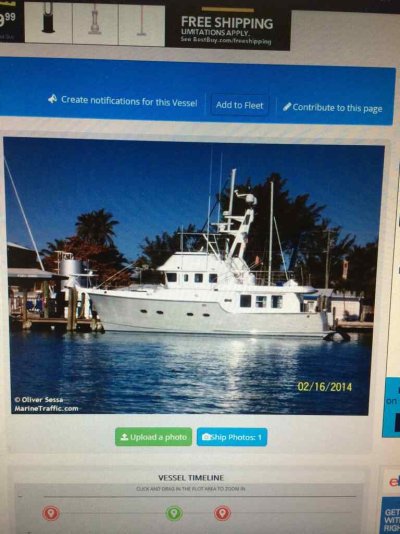
So I was poking around the old interweb, researching AIS, and I got directed to marinetraffic.com. Started poking around and saw this boat. Looks familiar....
ImageUploadedByTrawler Forum1431019901.260001.jpg

Also had this info on last known port. Can you turn this thing off if you don't want everyone to know where you are and where you have been?

ImageUploadedByTrawler Forum1431019945.783558.jpg

?
 
I've never come across any info on how to make marine AIS data "private". I don't know if it's possible.
 
It has silent switch so you can TX at all but otherwise no.
 
We can power ours down, and sometimes I remember to do that when we're at our home marina.


-Chris
 
Mine has a stop transmitting switch. It still receives just doesn't transmit.
 
Mine, a Furuno FA150, has no "receive only" mode. If the transmitter is off, so is the receiver. I understand that newer versions of that model (mine is now 6 years old) have a transmit off button. Even so, I leave mine on. Its nice to be able to check up on the boat and verify that it is where I left it.
 
Mine, a Furuno FA150, has no "receive only" mode. If the transmitter is off, so is the receiver. I understand that newer versions of that model (mine is now 6 years old) have a transmit off button. Even so, I leave mine on. Its nice to be able to check up on the boat and verify that it is where I left it.


I didn't think of that-- kind of like a "find my boat" feature like the iPhone. ?

I was just intrigued that someone could so easily find out where I am (or where the boat is) if they know the boat name. I'm not running drugs or anything, but it just doesn't seem very private.

I suppose one could just power down the thing if there is not a "no transmit" feature.
 
I have a Vesper. It has a Harbor mode and an Open Water mode. In fact I think it has 4 modes in total just can't recall the other two right now.
 
My Digital Yacht transceiver has a transmit off switch. But you have to install it yourself.
 
If you broadcast your position over the VHF every minute or so, then anyone listening will know where you are. That's pretty much the definition of AIS. The side effect is.... everyone knows where you are.
 
I did see a boat last week as I was entering Narragansett Bay. AIS on. Out of curiosity, I went on MT and looked her up. Name, History and all was there. But there was no picture. I thought I'd add one. Lo and behold the owner has somehow stopped marine traffic from posting ANY photos of the boat. But the information about voyage, history is all public knowledge once transmitted.
 
Seems like cheating if you want to know every other vessel but you want to be unidentifiable. Using an imaginary boat name may be one ploy, but I don't know if that is legal or that you'd want that in an emergency or even in ordinary operation. Most "B" boats don't display a picture, but you'd hope they would transmit the boat's name.
 
If you broadcast your position over the VHF every minute or so, then anyone listening will know where you are. That's pretty much the definition of AIS. The side effect is.... everyone knows where you are.

True. The intent is that boats that are close by know where you are so that they can plan accordingly. The CG and VTS can also see you thanks to their well place antennas. However, thanks to marinetraffic.com and the stations that collect AIS data and send it to them, the whole world can see where you are. That wasn't the intent of AIS - rather an exploitation of the data by a commercial website. I'm not saying it's wrong - just not the intended purpose.

Richard
 
I think this is life in our current, highly communicative world, and highlights the need to be thoughtful about what info you put out there. Our lives and interests are sliced and diced by the likes of facebook and fed to companies marketing products. But everyone provides that info freely and willingly. I think you just need to assume that if you put any info out in the public, then anyone, anywhere can see it and know about it, and use it.

As for our boat positions, that was/is public knowledge even without AIS. If, for example, MarineTraffic hired people to walk docks and report back the names and positions of observed boats, and that was published on their web site, you would have much the same effect. The only real difference is that now the info can be electronically collected, so is economically viable where it otherwise probably wouldn't be.

Please note that I'm not necessarily defending MarineTraffic specifically, just trying to point out how communications has changed things. It used to be that only people in proximity of your boat knew it was there. Now everyone can know. It used to be that only people walking down a little street knew what it looked like. Now everyone knows.
 
All of the AIS transponders that I have worked with had the option to turn off transmitting, while still receiving. I used to actually use that switch whenever we were diving on newly discovered shipwrecks, so other divers/boats couldn't poach the position.

Another interesting thing about MarineTraffic is their coverage (based on volunteer AIS receivers) is pretty spotty. For example, if you check on Sea Eagle, you'll see the latest position is 3 months old because the boat moved out of range. Other sites have more current information.
 
Most "B" boats don't display a picture, but you'd hope they would transmit the boat's name.

Class A's don't display any pictures either. Marine Traffic has a database from which they display pics of selected vessels.
 
Most "B" boats don't display a picture, but you'd hope they would transmit the boat's name.

Class A's don't display any pictures either. Marine Traffic has a database from which they display pics of selected vessels.


The VHF transmission includes MMSI, name, and some vessel parameters (length, beam, etc.), status (underway), speeds, and so forth. Class A transmitters -- usually large ships -- can enter some additional info, like destination. (Some of that presumes the installer filled in the appropriate blanks, typed correctly...)

Not sure if I can add that additional info or not, too.... but doing so would be way more work than I'm willing to do anyway... unless we were perhaps on a long-distance cruise.

Pics can be attached at the website level (marinetraffic, etc.). The pic of ours was apparently taken by some random photographer, and then passed to marinetraffic. Or perhaps linked on marinetraffic by that photographer. I haven't really looked into the "how" -- although it looks like I could post pics myself, if I wanted to.

-Chris
 
I just installed a Raymarine transceiver and I can either wire in a physical switch or go to my MFD and turn off the transmitter part.
 
Another interesting thing about MarineTraffic is their coverage (based on volunteer AIS receivers) is pretty spotty. For example, if you check on Sea Eagle, you'll see the latest position is 3 months old because the boat moved out of range. Other sites have more current information.

There seem to be 3 or 4 popular AIS receiver network web sites. One of them (forget which) has a layer you can turn on that actually shows the receiver locations. I haven't been able to find similar information on the other sites.

Has anyone seen a good "coverage map" or list of receiver locations that would allow you to choose which site to use, given your intended course? I'm thinking that would be good information to provide to folks who are staying home and watching your progress. Or to test your range when first installing an AIS transceiver.
 
I always assumed the different sites were all using the same underlying data. I'm not sure if I read that somewhere or just assumed it out of thin air.

Anyone know for sure? The site I've been using is marinetraffic.com. What other ones are there?
 
Marine traffic has the same ability to show shore stations and their identity. None of the AIS has the ability to connect Photos to the programs. That is all done by the particular website you are looking at. I subscribed to the Lloyds of London website. It was the best coverage. But after a couple weeks they shut it off until you pay for it. AFAIK Marinettraffic is the only free one ( with a slight delay). Although the delay is often negligible in real life. As far as having others 'follow you' Marinettraffic is free.

@Capttom: The websites don't work like that. You enter your. Desired vessels name, If it's in range is shows up. If not it doesn't.

@Twistedtree: the more expensive ones use Satellite reception. But they are ALL for pay. Even Matinetraffic has the 'pay' option with up to date info derived from both satellite and shore stations.

Marinetraffic has an app you can download and hook up to your AIS unit to 'rebroadcast' your data o provide a 'moving hotspot'. Everything your machine 'sees' it uploads to MT to make a more complete view. Look for it under FAQS on MT for more info. Or they will send you a unit to use at home, as long as you agree to transmit constantly to them.
 
Last edited:
BTW, starting in 2016 all commercial vessels must be broadcasting on AIS.
 
I was under the impression that was already the rule
 
Our Raymarine AIS has a "silent" mode which can be switched on/off.

What about this: Marine Traffic has shown Lady Di in Ft. Meyers ever since she passed thru there in late September.

Have taken her out of Marco 20 times since then with no change. No, I'm not on "silent" and other AIS targets show up fine.

Just curious...
 
I always assumed the different sites were all using the same underlying data. I'm not sure if I read that somewhere or just assumed it out of thin air.

@Capttom: The websites don't work like that. You enter your. Desired vessels name, If it's in range is shows up. If not it doesn't.

Twisted, I can confirm that they don't all use the same data, since when I turn on my AIS, even if I leave it on for hours, I show up on some sites, but not others. Looking more closely, other large commercial boats in the same area also show up on the same sites as me, but not on the ones I don't show up on. Moral of the story: not all sites have receivers near my marina.

Cappy, I tend to use the sites the opposite way; select an area of interest and see what ships are there. Some harbors show no ships on one web site, but a bunch of them on another. So again, I know the coverage is not consistent from site to site.

What I'd really like is some way to know which sites cover a given area of interest, like where I am right now (for the people ashore) or where I'm going (for me.)

As I said, one of the sites does allow you to display receiving stations, but I can't find that option on the others. The ideal would be a "coverage map" like you see for cell phone companies. But there's no competitive advantage for AIS web site companies to do that, so it would have to be a 3rd party.
 
I can confirm that they don't all use the same data, since when I turn on my AIS, even if I leave it on for hours, I show up on some sites, but not others. Moral of the story: not all sites have receivers near my marina.

Cappy, I tend to use the sites the opposite way; select an area of interest and see what ships are there. Some harbors show no ships on one web site, but a bunch of them on another. So again, I know the coverage is not consistent from site to site.

.

What I've found is the 'paid' sights have more consistent coverage. They use not just user submitted data, but satellite info. I personally have not found the need to pay for the website info. The slightly delayed info I get on my Iphone suffices. Although, technically I am not supposed to be using the iphone data for navigation, I almost always use it to do a look around for other large commercial vessels in addition to my chart plotter with AIS overlay. The vessels in close are often shadowed by buildings, mountains (think Hudson River around Bear Mtn Bridge) You can be within 4 miles of someone and they are invisible on your own AIS, But go to Marinetraffic and whoosh, there they are! Regarding the updated AIS, I have not seen true real time ais displays on the internet that were free. None of the free ones are real time. My company pays for realtime ais info to the tune of 1200 per year. I just don't feel it's necessary to pay. One of the benefits to being a 'live supplier' of data to MarineTraffic is you are given free live streaming info as a reward. Maybe this is why some vessels hook up the data stream? Not sure.

Although the following is just my own anecdotal opinion, It does seem to be pretty consistent.

In use there does seem to be some errors in data reception, transmission and use. The AIS seems to 'blink'. This may help explain your 'gaps' in coverage. The transmission is every couple seconds or so Class A, or couple minutes on Class B. But there seems to be either a reception problem, or a transmission problem on a lot of vessels. It seems that many minutes go by sometimes until positions update. This shows up as 'jumpy' targets on the plotter. I have been on several vessels that have 'blind spots' in their AIS reception. One small tanker actually received almost NO ais info from vessels ahead of the beam, but had exceptional reception from abaft the beam. So there are antenna issues, and location issues.
 
Last edited:
The different websites (ShipFinder, MarineTraffic, etc) are all private. They rely on users installing software on a PC with a land-based AIS receiver. It packages up the AIS data and sends it over their private API's to their servers where the data is then distributed for viewing. In return, the user gets special access to the full dataset for free or less money.

The US government has a satellite network that is recording all AIS traffic. It allows NOAA to pick an area and see the tracks of all vessels through it over a given span of time. I'm sure there are other governmental uses of the data for intel too. I've been told that all of the government satellite AIS information is confidential for commercial and private use. I've been on telephone calls with cartographers who looked up a particular spot to see where the bulk of vessels went. They can access that information instantly.
 
Back
Top Bottom