MichaelD
Senior Member
This is by way of confession, and hopefully some learning. On August 27th of this year I hit a plainly marked reef. At least it's plainly marked in hindsight. It was completely submerged when I hit it.
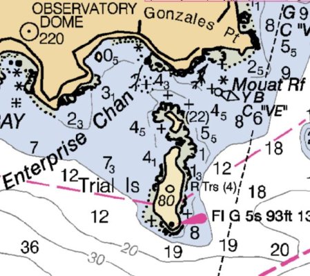
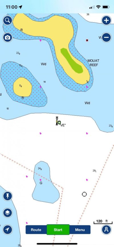
On the south end of Vancouver Island, near Oak Bay SE of VIctoria, is Muoat Reef. I was travelling through Enterprise Channel enroute to Victoria on an unplanned "shortcut"; i.e., I had not thoroughly vetted the route in advance. The problem is easy to see in this Navionics view sitting at my desk, but at the time, in the clutter that can happen on chartplotters, it looked to me like I had a clear path and I did not see that there was a Cardinal Buoy showing south of danger.
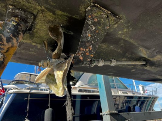
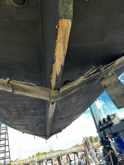
So, motoring along I noticed a hundred or so yards off my port bow, a funny looking spherical, grey grungy buoy, very hard to see against background of Trial Island. "Huh", thinks I, "what's that?" It's now approaching my beam as I take the glasses and look and see "oh, it's a bit yellow, and it has two black triangles above pointing down which means it's south of danger.....just like it's south of me...." As the wheels spin I grab for the throttles/shifters just as a loud bang occurs and the boat levitates a foot or so, followed by some metallic clatter, and then I'm free.
There followed a very tense couple hours as we assessed damage, talked to the Canadian Coast Guard, found a yard that would open for us on Saturday about 20 miles away, and were able to go under our own reduced power to a haul out. The support from the Coast Guard and from Vector Marine Services in Tsehum Harbor along with a few other marinas and Vessel Assist that got us the yard contact, were tremendously comforting and helpful.
The lesson learned is obvious; but, it's worth noting that important ATONs may not always be easy to see or look like you might think they should. This one was definitely not up to the task...nor was our skipper.

On the south end of Vancouver Island, near Oak Bay SE of VIctoria, is Muoat Reef. I was travelling through Enterprise Channel enroute to Victoria on an unplanned "shortcut"; i.e., I had not thoroughly vetted the route in advance. The problem is easy to see in this Navionics view sitting at my desk, but at the time, in the clutter that can happen on chartplotters, it looked to me like I had a clear path and I did not see that there was a Cardinal Buoy showing south of danger.
So, motoring along I noticed a hundred or so yards off my port bow, a funny looking spherical, grey grungy buoy, very hard to see against background of Trial Island. "Huh", thinks I, "what's that?" It's now approaching my beam as I take the glasses and look and see "oh, it's a bit yellow, and it has two black triangles above pointing down which means it's south of danger.....just like it's south of me...." As the wheels spin I grab for the throttles/shifters just as a loud bang occurs and the boat levitates a foot or so, followed by some metallic clatter, and then I'm free.
There followed a very tense couple hours as we assessed damage, talked to the Canadian Coast Guard, found a yard that would open for us on Saturday about 20 miles away, and were able to go under our own reduced power to a haul out. The support from the Coast Guard and from Vector Marine Services in Tsehum Harbor along with a few other marinas and Vessel Assist that got us the yard contact, were tremendously comforting and helpful.
The lesson learned is obvious; but, it's worth noting that important ATONs may not always be easy to see or look like you might think they should. This one was definitely not up to the task...nor was our skipper.
Attachments
Last edited:
 but the story speaks to me on a couple points: