You are using an out of date browser. It may not display this or other websites correctly.
You should upgrade or use an alternative browser.
You should upgrade or use an alternative browser.
Cuba
- Thread starter Capt.Bill11
- Start date
The friendliest place on the web for anyone who enjoys boating.
If you have answers, please help by responding to the unanswered posts.
If you have answers, please help by responding to the unanswered posts.
Capt.Bill11
Guru
Capt.Bill11
Guru
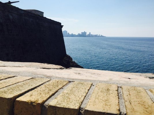
The Sloppy Joes in Havana is open again. The building partially fell down at one point. The government came in and took over some of the apartments around in, including my friends grandmothers apartment that was part of the same building but did not fall down.
The government wanted to move them out and give them 3 other apartments in another part of the city. The family tied to fight the move but just like here, the government won that battle.
The amazing thing is as my friend's sister stood there telling us the story (she still lives in Havana and I had not met her till this trip) I realized that when I stood there 22 years ago looking the then closed Sloppy Joe's, her family was still living there. Long before I met her and her brother. I told her this and she laughed and said her brother who would have been a little kid at the time probably was riding his bike around me that day because that's where he always played as a kid.
Once again proof its a small world.
Attachments
Capt.Bill11
Guru
Capt.Bill11
Guru
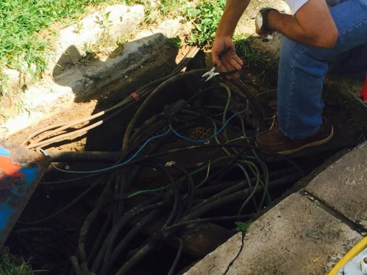
We had an issue at the marina with the power on the dock. It started with some smoke coming out from under a large metal access plate on the dock that gave my mate a good shock when he was standing on it when spraying the boat down.
So the marina sent over their electrician to take a look at it. Turned out one of the hot wires feeding the power post was fried. To fix it the electrician cut back the burnt wire then cut open the main wire feeding the dock and pulled out some strands from it. Then twisted them together with the strands of the cut back wire that feeds the post using no mechanical connection/connector. Finally just wrapping the twisted bare wires up with electrical tape.
And from then on we had good power to the boat.
"Electrical codes? We ain't got no electrical codes. We don't need no electrical codes. We don't have to go by any stinking electrical codes!"
Attachments
Capt.Bill11
Guru
McGillicuddy
Guru
- Joined
- Dec 4, 2015
- Messages
- 754
- Location
- USA
- Vessel Name
- Scot Free
- Vessel Make
- Cheoy Lee 53' Efficient
Yowzah! There is so much wrong there with these pictures I don't know where to start.. In fairness, Let's just say he has a big ass watch.
Sent from my iPad using Trawler Forum
Sent from my iPad using Trawler Forum
Donsan
Guru
- Joined
- Jul 6, 2014
- Messages
- 2,300
- Location
- United States
- Vessel Name
- No Mo Trawla
- Vessel Make
- Hurricane SS188
What? No GFI at the docks in Cuba??? Outrageous!
Capt.Bill11
Guru
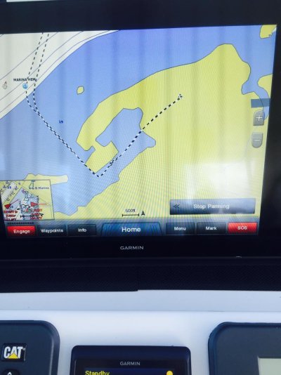
I was warned about the limited detail that the Garmin electronic charts gives you for Cuba. And that turned out to be an understatement.
The picture posted below will show how poor the data is for Marina Hemingway when using the Garmin charts.
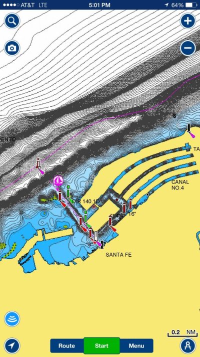
The picture in my next post is a screenshot of that kind of detail you get with the Navionics electronic charts of the same area.
As you can see by my track in the picture below, according to the Gamin chart, I was docked on the hard.
Attachments
Last edited:
Capt.Bill11
Guru
I was warned about the limited detail that the Garmin electronic charts gives you for Cuba. And that turned out to be an understatement.
The picture posted below will show how poor the data is for Marina Hemingway when using the Garmin charts.
The picture in my next post is a screenshot of that kind of detail you get with the Navionics electronic charts of the same area.
As you can see by my track in the picture below, according to the Gamin chart, I was docked on the hard.
The reason we always have two sets of charts open and have even searched a third. Every system has areas in which it's great and others that it's poor. Garmin, lousy for Cuba, has great charts of the inland rivers and lakes as we used them coming down the Illinois River. Furuno river charts are much better than they were.
Interestingly too, talking to people about traveling the same areas a few years ago and they couldn't find a decent chart. I'm sure the charts for Cuba will change a lot now.
You sure point out the reason for not completely trusting any chart though.
- Joined
- Apr 15, 2008
- Messages
- 13,738
- Location
- California Delta
- Vessel Name
- FlyWright
- Vessel Make
- 1977 Marshall Californian 34 LRC
Bill, do you have the optional "SonarCharts" on your Navionics? (If you click the blue logo in the lower left corner, you can toggle between charts,,,Govt Chart, Navionics, SonarChart.)
The improved barothymetric data is notable in some areas, not so much on others. As wifi connected mariners frequent the area and Navionics receives more crowd-sourced updates, they're bound to provide better bottom data than the standard charts. I suspect the shoreline presentations will improve as well.
I can't help but think that this will be the way we'll be able to quickly see current bottom changes like those experienced following Hurricane Matthew and places like Cuba that, until now, weren't frequented.
Capt.Bill11
Guru
Bill, do you have the optional "SonarCharts" on your Navionics? (If you click the blue logo in the lower left corner, you can toggle between charts,,,Govt Chart, Navionics, SonarChart.)
Yes I do.
Attachments
Capt.Bill11
Guru
After the latest update I alsohave the ability to create my own depth charts with my Garmin system using their QuickDraw software.
But I have yet to start using it. I think I'll give it a shot on my trip up from Key West to FLL around the first of Nov.
But I have yet to start using it. I think I'll give it a shot on my trip up from Key West to FLL around the first of Nov.
Last edited:


