Garmin Sonar for Cruising

The friendliest place on the web for anyone who enjoys boating.
If you have answers, please help by responding to the unanswered posts.

AnsleyS

Senior Member
Joined
Aug 18, 2019
Messages
141
Location
USA
Vessel Name
Jubilee
Vessel Make
Kadey Krogen 42
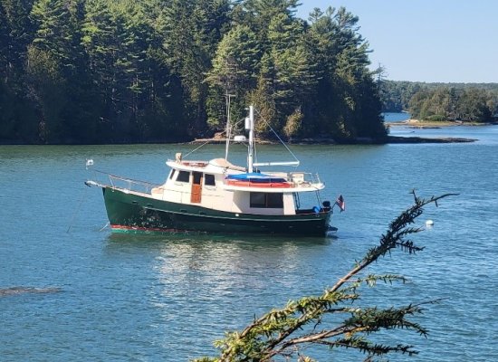
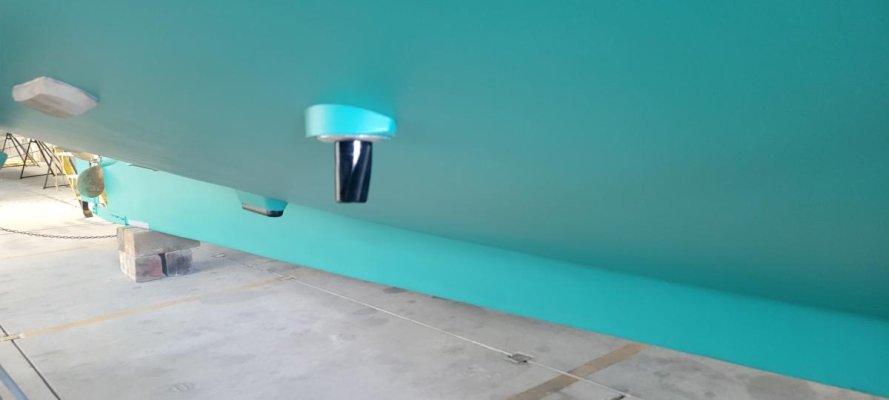
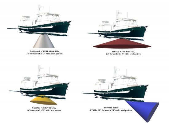
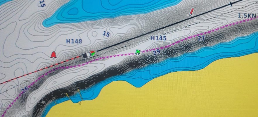
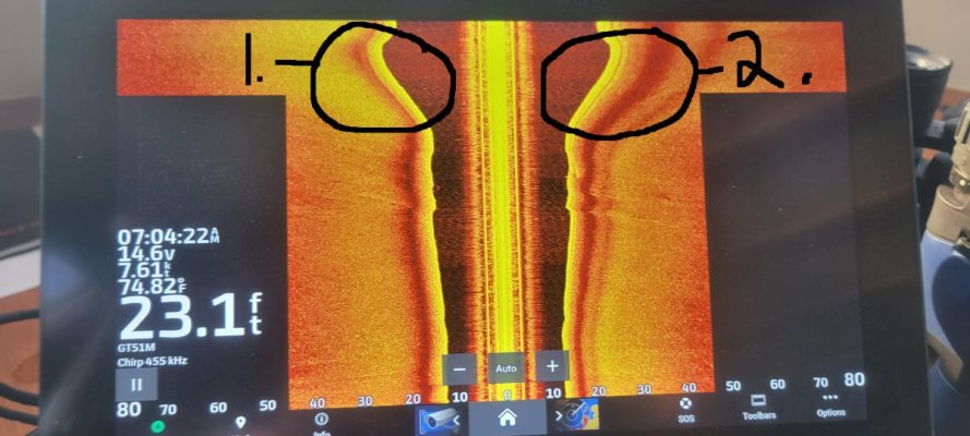
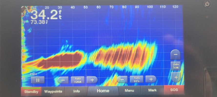
Garmin devotes most of their sonar marketing to fishermen but we have put together a Garmin system on our Krogen 42 and are evaluating it for cruising. We bought a 1983 Krogen and removed the old electronics and installed a Garmin system with three multifunction screens, a GPSMap 8616xsv, GPSMap 8612xsv, and a GPSMap 7407xsv. The “xsv” suffix indicates that the screen can receive and display high definition sonar signals. The system also includes a GMR Fantom 24-inch radar dome, a AIS 800 Transceiver, an autopilot with the Reactor 40 compass, the GHP Smart Pump v2 and the GHC20 control head in the pilothouse. These are connected with the NMEA200 hub and a high speed network through the GMS-10 Network Port Expander. There is an AIS antenna on the mast and an external GPS antenna for the AIS. There is a GC200 IP camera covering the stern and two VHF radios with position data vis our only NMEA0183 connection. The sonar transducers are the GTS1M-THP which are a pair mounted on either side of the keel and are an all-in-one transducer set for (1) mid-range CHIRP traditional, (2) higher frequency “ClearVu” and (3) a flexible frequency side view. Also mounted is a forward scanning sonar with the Panotix PS51-TH transducer. This system has so many data paths that I needed to map it for clarity.

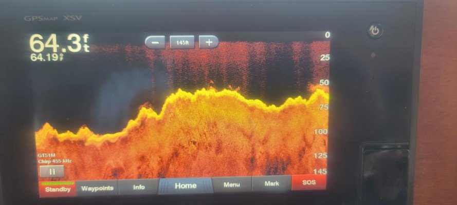
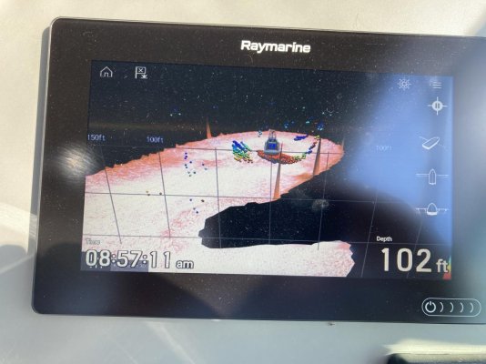
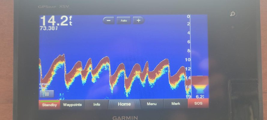
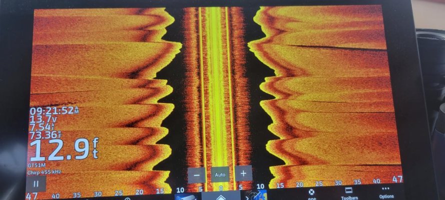
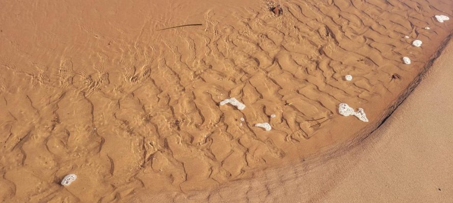
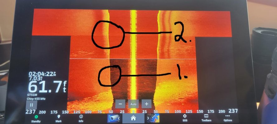
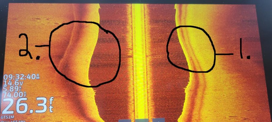
As we started to use this system, we started to experiment with the different views and their use and then we started to vary the frequency of the transmission and found some interesting things. We started to be able to scan an anchorage to look at the bottom before setting the hook and we started to wonder if we could judge the density of the bottom using different frequencies. This is an ongoing project so I welcome your thoughts along the way.
 

Attachments

  • Jubilee.jpg
    Jubilee.jpg
    164.3 KB · Views: 58
  • 20210617_151548.jpg
    20210617_151548.jpg
    24 KB · Views: 53
  • 20210617_151557.jpg
    20210617_151557.jpg
    32.5 KB · Views: 62
  • 20230819_102522.jpg
    20230819_102522.jpg
    58.8 KB · Views: 60
Following.

I installed Simrad in July, including a mid-range chirp and forward scan.

I have read that one can tune the chirp (and possibly forward scan?) to the purpose you cite, of looking at bottom composition for holding.

But having said that, I have yet to find anything online that discusses it.

Everything transducer is always about finding fish.
 
Google and You Tube will provide tons of info on how to use fishfinders to estimate bottom makeup...... This is just one minor reference, plenty more out there. Look at You Tube for good visuals.

How to Read a Fish Finder (With Pictures)

"Different types of bottom consistency
With a little practice, you can tell a lot about the consistency of the bottom based on the sonar signal.

A hard bottom will show up as a stronger, thicker line, compared to a muddy bottom, which looks broader and more “fuzzy” on a 2D sonar fish finder screen."

You Tube video....

 
Last edited:
And why is it show first two bottoms then three?
 
Like all net and You Tube info...there is a ton and you have to wade through it to get to the good stuff.

Seems like manufacturers have jumped on the bandwagoin. For fishfinder info try manufacturer channels like Lowrance, Hummingbird, Garmin, Simrad....etc...
 
This is a photo of the MFD screen on my Raymarine Axiom+ with the Real Vision 3D depth sounder module. There is a ship wreck in 100’+ right under the boat icon. They market it for fishing but I just wanted a toy to play with. This was taken in Thunder Bay here on Lake Huron. There are many old wreck sites there.
 

Attachments

  • IMG_1498.jpg
    IMG_1498.jpg
    124.8 KB · Views: 71
The transducers that we installed included the Garmin GT51M-THP Port and Starboard pair which are all-in-one, Traditional, CHIRP, “SideVü”, and “ClearVü” variable frequency transducers that contain a fast response water temperature sensor. The variable frequencies enable different views of the bottom. Generally, the lower the frequency the more penetrating power in the beam and the higher the frequency the more detail is shown. CHIRP (an acronym for Compressed High-Intensity Radiated Pulse) is a system that sends out a multi-frequency pulse over time which results in an improvement of the image you see.

The Garmin GT51M-THP transducers offer the “Traditional” CHIRP 80-160 kHz transmission in a cone pattern which is 24° forward/aft by 13° wide; the “SideVu” CHIRP 260-455 kHz, oval pattern 2.0° forward/aft x 51° wide; and the “ClearVu” CHIRP 455 kHz, oval pattern 1.4° forward/aft x 29° wide. These give different views when in use.

An example was when we were cruising down the Ottawa River from Ottawa by the Petrie Islands we encountered a rippled sand bottom contour that changed depth by four to six feet as we passed over the ripples. These big ripples are similar to smaller ones that we saw on the beach in Prince Edward Island. The Traditional CHIRP picture shows the bottom variation directly under the boat with the 80-160 kHz transmission and the “SideVu” shows a 51-degree fan at 455 kHz. The higher frequency reveals more definition.
 

Attachments

  • Jubilee's Transducers.jpg
    Jubilee's Transducers.jpg
    83.3 KB · Views: 50
  • 20230718_092332.jpg
    20230718_092332.jpg
    51.6 KB · Views: 53
  • 20230718_092157.jpg
    20230718_092157.jpg
    77.5 KB · Views: 51
  • 20230718_092151.jpg
    20230718_092151.jpg
    122.1 KB · Views: 62
  • 20231002_102132.jpg
    20231002_102132.jpg
    112 KB · Views: 51
An example was when we were cruising down the Ottawa River from Ottawa by the Petrie Islands we encountered a rippled sand bottom contour that changed depth by four to six feet as we passed over the ripples. These big ripples are similar to smaller ones that we saw on the beach in Prince Edward Island. The Traditional CHIRP picture shows the bottom variation directly under the boat with the 80-160 kHz transmission and the “SideVu” shows a 51-degree fan at 455 kHz. The higher frequency reveals more definition.

You probably know this, but for those watching at home, wind chop or waves on the surface will result in a bottom picture like your photo. The boat rising and falling translates to a wavy bottom since the electronics read the varying depth.

Nice system you have. Garmin makes some very good electronics.
 
Thanks for the thoughts, Guy. The Ottawa River was flat calm when we went through there. That is why I noticed the six foot sand waves.
 
In some spots, sand waves used to be charted on Raster Charts, not sure if on Vector Charts as it may take a few clicks to find the info which I never got around to.
 
Last edited:
I will add that I have the PS51-TH forward looking transducer in conjunction with a GT23M-TH ClearVu transducer.


Indeed the forward looking sonar is very useful to scout anchorages in southeast Alaska where frequently abrupt changes in depth can be found. I find switching between bottom fill on or off depending on whether there is any vegetation in the water to eliminate false bottom readings. You can easily see the anchor drop and contact bottom, identify underwater pilings, etc.


The ClearVu sonar transducer works well at depths up to about 1000' where it loses the bottom. Although it doesn't matter in these depths, when the bottom echo is lost it returns depth readings of <10' which means I have to turn off the shallow water alarm to avoid nuisance alerts.


Overall I am pleased with the setup.
 
Furuno is only side scan with their 3d system so not that interesting to me. . I wish it had forward scan. Even then I’m not sure I could justify it.
 
Chirp vs Forward Scan

My new build and new electronics were operational in late July, so scant experience with it, and its Simrad. I don't want to turn this into a Simrad thread but there is a detail some might like to know if readers are pondering it all for themselves.

Underway in deep water the only thing you probably want to see is the depth number in a panel containing other stuff like RPM, gallons per hour, etc. In Simrad that has to be from the chirp sonar, not Forward Scan.

Only one transducer can be operational at a time. If you are coming into a skinny water anchorage and want to look at Forward, you have to activate it which deactivates chirp. You can't run the full chirp screen such as those displayed above as samples. Or you can run Forward, but no chirp.

In theory you might want to be running 3 or 4 panels on the MFD: chart zoomed in, radar for distances to other boats, Forward for shoals and obstructions, and chirp for bottom composition. Can't. Have to choose between chirp and Forward. Making the switch between chirp and Forward involves a menu dive 2-3 levels down. Not bad but it does take a minute and more than a quick toggle from one to the other. With experience it will probably get to become more routine.

And that's Simrad. Garmin may differ.

I think all forms of sonar have a use case. Your call as to what's most useful for you.
 
Garmin lets one view different views at the same time. I can put the forward scan, the side scan and the downward scan all up at the same time. They can be shown on different screens or on a composite screen set up.
 
Garmin lets one view different views at the same time. I can put the forward scan, the side scan and the downward scan all up at the same time. They can be shown on different screens or on a composite screen set up.

Good info. Thanks
 
When we put this system into Jubilee, I wondered if I could see the middle and the sides of a channel well enough to navigate along a narrow path. The Atlantic Intracoastal Waterway and the canals in Canada came to mind. The side scan sonar looks out to the sides with a very narrow (2 degree) beam and the MFD displays a composite picture of the beam returns as one moves through the water. There is a transducer on either side of the boat and when those two beams meet straight below the boat there is some interference between the two. I noticed that at the higher frequency the interference band displays as a roll on the bottom. The first picture shows the side scan in two frequencies. The lower part of the picture was the lower 260kHz frequency and the upper part of the picture is at 455kHz. Notice that the number 1 circle shows no interference “roll” but the number 2 circle shows the “roll” at the higher frequency.

The second picture more dramatically shows the difference between circles 1 and 2. The “fatter” roll is toward deeper water. This difference is consistent whenever the beams see different depths on either side of the boat. The difference in the “fatness” of the rolls is indicative of the difference in the depths.

The next pictures illustrate this ability to tell where the deep water is under the boat. The chart shows that we were cruising down the river and we were between the navigational marks, in the channel, and the deep water was to starboard. The last picture shows the bottom “roll” to starboard (#2) is wider than to port (#1). If you want to see this in action, there is a short video of us on the Rideau Canal turning around a starboard corner on YouTube. You can see one of the MFD’s showing the side scan sonar. Notice that we were close to the point to starboard and you can see the fat roll to port.


Attachments

  • Sonar 3-1.jpg
    Sonar 3-1.jpg
    78.2 KB · Views: 35
  • Sonar 3-2.jpg
    Sonar 3-2.jpg
    124 KB · Views: 40
  • Sonar 3-3.jpg
    Sonar 3-3.jpg
    108.5 KB · Views: 36
  • Sonar 3-4.jpg
    Sonar 3-4.jpg
    91.3 KB · Views: 62
Forward Scan Sonar

We also have the PS51 on Jubilee and I use it to sniff out the shoals when going slowly into tight places. The picture shows a typical display when slowly underway. You can see that we are showing 34.2 feet under our keel and the beam goes out forward about 105 feet with a pretty flat shallowing bottom. The beam is twenty degrees wide. There may be some fish near the bottom at a depth of 22 to 27 feet and about 30 to 40 feet out. I am still leaning this system and I am looking forward to experimenting more with it this summer.


Here is a ten second video of this:


https://www.youtube.com/watch?v=WwImyVeQq6Y
 

Attachments

  • 20230718_092849.jpg
    20230718_092849.jpg
    70.2 KB · Views: 36
I also have a garmin and Chrip transducer. I don't care about fish I'm only interested in keeping my keel from contacting the bottom. What is the best setting for shallow depths ,what frequency?
 

Latest posts

Back
Top Bottom