Hurricane Irma

The friendliest place on the web for anyone who enjoys boating.
If you have answers, please help by responding to the unanswered posts.
Not to hi-jack this string but as a Native Houstonian who took 18" of water in my house last week (a house with 63 years of no water - and yes I have flood insurance), I'm curious what you're hearing in the press about our response to Harvey. So far, it's a huge mess but we are just "gettin' er done". People here are stoic. Nobody's complaining or fighting. It's like ants rebuilding a kicked-over mound. Everyone's helping each other and 80% didn't have flood insurance. 300-400,000 homes flooded or damaged in the region. FEMA was broke before Harvey...now they're broker.

My gas still works so I'm grilling steaks for my demo crew on Friday. We still have many communities under water and inaccessible. JJWatt raised $20 million in 6 days.
BTW, my adjuster's here from Jacksonville. He's a little freaked out about Irma plus he's on no sleep, sharing a hotel suite with 3 other guys. He said he knows where he's probably headed next....back home, unfortunately.

Just know we are pulling for Florida over here.

Again, Irma's the subject, but If things go south, I hope we're a good model of human behavior. It's been pretty impressive.
 
That's a good report to hear from a local. I dropped my son off at UH downtown this weekend and it looked to me like people were getting back to business.

Houston is a resilient city.
 
Really spreading insurance adjusters thin. Some insurers are offering independent adjusters up to $1400 a day to guarantee availability.
 
Quote of the night from a governor of a state not to be named.

"This is a state of emergency, meaning we're in a state of emergency." He was speaking very slow so everyone could understand what he was saying apparently. Perhaps not bad to say it slowly and repeat most parts.
 
[emoji23][emoji23][emoji23]

He was actually speaking slowly? He's usually fumbling all over the words tumbling out of his mouth like a waterfall.
 
[emoji23][emoji23][emoji23]

He was actually speaking slowly? He's usually fumbling all over the words tumbling out of his mouth like a waterfall.

I didn't say which governor.

If you want to get out on the water, current forecasts are 1' seas here tomorrow. During Friday they grow to 6', Saturday to 16' and Sunday peak at 46'. Back to 3' by Monday late afternoon.
 
This is awful. Well wishes to all the southern TrawlerForum members.
 
My best friend is in serious condition in a Savannah hospital. He had a life saving operation last Friday and I was with him until I had to leave to come down to St Pete to take care of my boat which is also my home. My prayers to all in the path of Irma and especially to patients in hospitals in the direct path. I lived through Katrina and remember well the death toll in the hospitals that did not evacuate and decided to 'shelter in place'.
 
Irma

I was planning on a survey and see trial tomorrow in the N Palm area, sounds like the sea state would have been OK. We backed it up a week, no sense doing it twice. The boat is at Cypress Island Marina in Palm Beach Gardens, looks like a good place to ride this out. Just hope the current owner does't have it insured for significantly more than the contract price.:cry:
 
They still are unsure of where it will make the northward turn. And where it makes that turn has a HUGE effect on impacts. Late turn, Keys and Sfla. Early turn, Bahamas and then Carolinas.

Uggh. Got family in the Keys and Carolinas. This family might get a "two for one" deal.

Folks in Keys have already evac'd.

Interesting to hear this. I have a favorite webcam located in Key West at Sloppy Joes. Here is a link... Live Duval Street

I've been checking in all morning and every time I look I see people and or vehicles. I know that I'd be out of there!
Bruce
 

Attachments

  • IMG_0397.JPG
    IMG_0397.JPG
    82.8 KB · Views: 105
That "before" picture, by the way, is a total PhotoShop creation. There is no way all the boats are identical side by side like that. It's probably a marketing brochure picture.

I don't doubt the damage done by the storm, and feel for all those impacted, but there is some theatrics in the presentation that reduces the credibility of PassageMaker, in my mind.
 
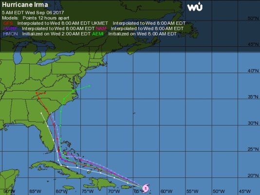
I know they issue new advisories every 3 hours, but does anyone know how often they re-run the computer models and create new spaghetti charts ?
 
My understanding is that most of the "traditional" models are re-run at 2-3 hour intervals but that the European model is not. Think I read that it re-runs at something like 12 hr intervals. So depending on when all the models are posted, the European "line" might not have been updated, and may look like the outlier. But it's also getting a lot of press for being the most accurate predictor, using a more comprehensive combination of inputs.
Richard on Dauntless could describe this in better detail.
 
I think run times vary with the models. I check Passageweather every few hours and it seems to update like every six hours. They seem to integrate the various models and historically have been pretty dang good. I don't bother with the spaghetti models as there are simply too many of them.
 
I know they issue new advisories every 3 hours, but does anyone know how often they re-run the computer models and create new spaghetti charts ?

Benthic,

Seems to be either 2 or 4 times a day depending on what model.

From the site that BandB supplied us:

https://www.tropicaltidbits.com/ana..._mslp&runtime=2017090706&fh=96&xpos=0&ypos=40

You can select the time the model was created on the right in the little drop down box below the grey Mesoscale and Climate.
Then on the upper right of the map you see the init: (when created) and when valid by date or forecast hour.

I believe that's the way it works.
 
looks to be the Moorings charter fleet in the first pic... bet you could pick up a cheap catamaran now...
 
"That "before" picture, by the way, is a total PhotoShop creation."

Oh, ye of little faith! Have a look at the drawing below, showing the mooring scheme. Google for images; there are several from various vantage points. There are images from other years showing similar line-ups. Paraquita Lagoon, Tortola
 
Local is very wrong. I just took 20'draft up Savannah river 18 miles from Jetties. Container berths (ships ) are 20 miles up. Not sure above container docks but I bet it is a wonderful hurricane hole.

Actually I'm the one that was wrong on the distances. Local said pt wentworth which is where the ship traffic goes as far as.

In any case... it doesn't make sense for me.
 
IMG_0926.JPG

I can't figure out what the white model is on this map. Am I blind?

https://www.wunderground.com/hurricane/atlantic/2017/tropical-storm-irma

Edit:

Wait I see it. It's some U.K. Model. For some reason weatherunderground will not display the EU model, which has been the most accurate allegedly. My Windy app uses the EU model and it has Irma hitting the Keys and moving up the east coast of FL.

I know I shouldn't focus so much on these individual models with the storm still this far away (margin of error 4 days out is 175 miles), but I'm just geeking out on all this stuff right now.
 
Last edited:
Interesting to hear this. I have a favorite webcam located in Key West at Sloppy Joes. Here is a link... Live Duval Street

I've been checking in all morning and every time I look I see people and or vehicles. I know that I'd be out of there!
Bruce

For Key West, that looks pretty close to deserted. Seems as though people have cleared out, aside from a few stragglers.
 
Actually I'm the one that was wrong on the distances. Local said pt wentworth which is where the ship traffic goes as far as.

In any case... it doesn't make sense for me.

Theres just "navigable mud" for the small boats above port wentworth. And PW isn't a good place for us small guys anyway, all the big boys will be crowded in there playing bumper boats.

There's no good rivers to crawl up around here (savannah) unfortunately. I'd go up the ogeechee but the bridges keep you from getting where you need to go. :nonono:

we're tied up at the marina with extra fenders, extra lines. I'm just worried about all that surge. :eek: Over 7 or 8 feet, there's no telling what will happen....

please go east! veer east!!
 
My best friend is in serious condition in a Savannah hospital. He had a life saving operation last Friday and I was with him until I had to leave to come down to St Pete to take care of my boat which is also my home. My prayers to all in the path of Irma and especially to patients in hospitals in the direct path. I lived through Katrina and remember well the death toll in the hospitals that did not evacuate and decided to 'shelter in place'.

I don't know which hospital in Savannah or it's location, but it differs a bit from Katrina in that in Katrina the entire area was subject to surge. With Irma, it's the coastal area that is being evacuated while any hospital that's inland should be in better position. Key West Hospitals are evacuating. Fort Lauderdale hospitals are not in evacuation zones.

Now, I still understand the fear and if I was his family and he could be moved I'm sure I'd want it. We spoke to a family in Houston whose father had just had a double lung transplant. Recovery means high dosages of immunosuppressants and very weakened immune systems. He had just returned home and the doctors quickly moved him into a hospital and then had him evacuated to Dallas.

In addition to what the rest of us face, those hospitalized, with chronic conditions, in nursing homes, immobile, requiring treatment like dialysis or on oxygen face far more issues. We just checked on an 84 year old friend here. She has many friends in assisted living.

Your post is a great reminder to think of all those.
 
Wow. I suppose that's fairly safe since they do it all the time, but it sure looks sketchy to me.

What's the reason for a prop instead of a regular jet?

Is the guy sitting in the middle working the throttles? Sure seems like a lot of throttle movement, but I'm obviously not a pilot.

They are Allison Turboprops. God bless 'em, they may be the best storm engine ever accidentally discovered. Plane is the ole P-3 Orion, whose passenger airframe was once the infamous Lockeed Electra I believe. Had a few problems with those but the Orion just keeps on cranking.

Thanks for bringing up a plasant distraction from this constant worry of Irma.
 
Last edited:
Back
Top Bottom