Hurricane Irma

The friendliest place on the web for anyone who enjoys boating.
If you have answers, please help by responding to the unanswered posts.
The P3 can take the loads because as new passenger planes the wings fell off , so the entire structure was beefed enough to stay together in flight..

Sadly this added weight so the aircraft was no longer useful as a people mover.

The senator from GA came to the rescue by having the US Navy purchase the aircraft to use as patrol units.

Sadly the stiff wing structure gave a crappy stiff ride , but it was OK as a patrol aircraft.

In a thunderstorm gusts can go up and down at 3,000 to 5,000 fpm.

The pilots will attempt to maintain a constant air speed that is chosen by the mfg to keep the aircraft together.

To maintain a constant air speed the difference between going up 3000fpm and down 3,000fpm requires constant throttle adjustment.

"The guy in the middle" is the plane captain , the enlisted person who maintains the aircraft and enlisted crew.

P3's can take it but the ride is rough .
 
Obviously we don't know yet where or at what force the hurricane will hit. Interesting looking at the various models in that they now vary greatly from West of Key West to East to further East. So they have it cutting through the state, just onshore, just offshore, and further offshore. All obviously have different impact. However, further out, where less reliable, they all have it much the same even cutting through western NC, Eastern TN, KY, W VA. Now obviously at much less force by then.

We've found it interesting looking at our area specifically on forecasts such as Windy. We know not definitive but interesting.

Not surprisingly that the ECMWF and GFS differ significantly in speed and direction based on where they have the eye of the hurricane ECMWF has the 74 knots as it has the eye crossing just west of us between 1100 and 1200 on Sunday. GFS has it passing well East of us between 0900 and 1100 on Sunday and winds at 78 knots. GFS does have 103 knot winds hitting Freeport.

Now, I think this is significant in noting while we keep hearing 175 mph winds (152 knots) by the time it reaches the mainland and especially as it passes over land, they'll be significantly less. Still they're strong enough to worry about but we will not receive the winds that have been seen in the Caribbean. Maximum wind speed when it reaches Key West now shown at 145 mph and by the time it reached northern Florida 100-120 mph.

Also what you receive at your location might be very different than 20 miles from you.

As a note, building code for Key West (of course a lot of homes there built before these codes) is 160 mph, Miami is 150 mph and Fort Lauderdale is 140 mph.

Same with Storm Surge. The current models show 15-20' in the Bahamas, but only 5-10' (worst case scenario) in the Keys and Miami and less than 6' in Fort Lauderdale and West Palm.

Since this is a boating site, if you want to go boating off the coast of Fort Lauderdale, Seas today are 1'. Tomorrow afternoon they reach 5'. Saturday afternoon late 18-21'. Sunday morning 34-41'. Sunday night 15'. Monday 6-8' and Tuesday 2'.

Main thing we all know is to follow it even more closely as it gets nearer to us and all the models could be wrong.
 
Last edited:
BandB

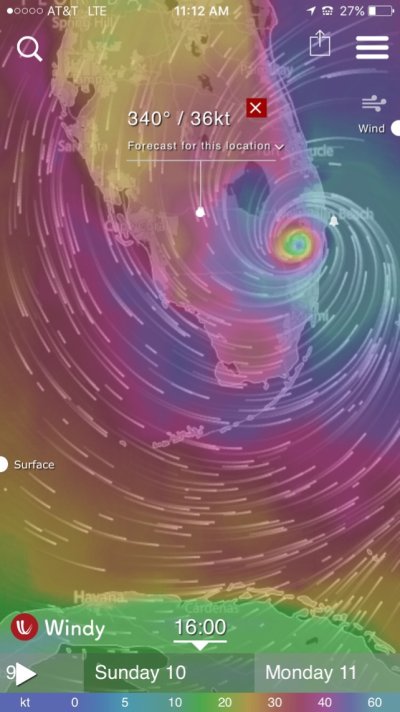
Yeah it's interesting, looking at the Windy app, with it set to the EU model which is the worst path for me, the highest wind I get at my location near LaBelle is 36kn. That's Sunday at 1600 hours.

Does that seem right??

IMG_0937.JPG
 
Last edited:
The P3 can take the loads because as new passenger planes the wings fell off , so the entire structure was beefed enough to stay together in flight..

Sadly this added weight so the aircraft was no longer useful as a people mover.

The senator from GA came to the rescue by having the US Navy purchase the aircraft to use as patrol units.

Sadly the stiff wing structure gave a crappy stiff ride , but it was OK as a patrol aircraft.

In a thunderstorm gusts can go up and down at 3,000 to 5,000 fpm.

The pilots will attempt to maintain a constant air speed that is chosen by the mfg to keep the aircraft together.

To maintain a constant air speed the difference between going up 3000fpm and down 3,000fpm requires constant throttle adjustment.

"The guy in the middle" is the plane captain , the enlisted person who maintains the aircraft and enlisted crew.

P3's can take it but the ride is rough .


Very interesting history. Thanks for the clarification on the Captain handling the throttles. Seems like a very active flying experience.
 
Cardude - they're old enough (around 40 years) that they still carry a Flight Engineer to "run" the mechanicals. That center seat is a dedicated crew position. I imagine it's a struggle to maintain the required flight profile with wild wind variance thay must encounter.

There is virtually nothing "automatic" on those birds. I never saw a Navy P3 that wasn't hand flown throughout - the autopilot (so the crews told me) almost never worked and if it was "up" nobody trusted it.

Not a Navy aviator - just a frequent hitchhiker with VP-94.
 
BandB

Yeah it's interesting, looking at the Windy app, with it set to the EU model which is the worst path for me, the highest wind I get at my location near LaBelle is 36kn. That's Sunday at 1600 hours.

Does that seem right??

View attachment 68358

On that path, yes. However, to see potential worse case you might move around the range of the hurricane to see what you'd have if it went to the west of that path shown. Then you'll probably see closer to the 75 knots we see. So, perhaps possible for LaBelle to see 75 knots or even more, but more likely less than 50 knots.

I'm not trying to diminish the danger or say those in the keys or on Miami Beach shouldn't evacuate because of potential surge. Just saying the likelihood for most of us when it comes to wind is tropical storm level.
 
Wifey B: There is a parade almost of boats headed from South Florida to Cancun right now. We think of escaping to the north and yet many are escaping to the southwest.

A good bit of boat traffic still on the ICW and some getting towed up the New River. The beach looks so strange to see the water calm, beach beautiful and no people. Well, except we did see one area with one group swimming and one group set up under a beach umbrella. :)

Not much traffic. I think everyone is in the grocery stores or at Home Depot and Lowe's. Not even as much traffic on the highways as I expected and that's good for those evacuating or it's bad because people aren't yet. Because not so much traffic here I even looked on the traffic cams from the Keys through Miami and surprisingly not jammed. :ermm:
 
Hi all,

I have really enjoyed following the discussion here on this thread over the past few days, thanks for all the knowledgeable input. I have spent a lot of time on the water back and forth between the Bahamas, FL and northeast but this is the first time having the boat in FL for hurricane season, so I've never been through this before. Long story short, in May we were cruising back from Green Turtle cay making a straight run for west palm and hit something unmarked about ~40 mi from west end on the north side of Grand Bahama. Tore off the stabilizer, separated the twin disk from the block and damaged the running gear. We limped in to west end to assess the damage and proceeded to west palm to get hauled out a few days later when the gulf stream calmed down.

Anyways... a 6 week repair time turned in to 8 weeks and now we're at 16 weeks and counting.. Which brings me to the Irma discussion, we're sitting on the hard in an area which according to the noaa chart, shouldn't be affected by surge in any category storm, but with the possibility of wind speeds being well over 100mph, i suspect there's a good possibility of the boats blowing over? Not to mention the hazard of having so many boats packed in, if one goes i suspect it's gonna take a few with it. I am not a physicist but have run some numbers best i can and the amount of force generated by those kinds of winds is pretty mind blowing. We have topped off all the tanks and are planning on adding some ballast in the bilge. Luckily we have some 100ft+ steel yacht to port, but a large sailboat who doesn't appear to be unstepping their mast to starboard. We are positioned bow facing southwest. Please point me in the direction of any existing threads on this or if you could provide me with any tips, past experiences or 'do's and dont's' it would be very appreciative.

Many thanks and keep the commentary coming. Good luck to everyone and god bless.

Thanks,
Pete
 
Pete,

Others more knowledgeable will chime in with hurricane info, but I was wondering about the object you hit. In July I crossed from West Palm/Lake Worth to Memory Rock.

Was the object near Memory Rock? I don't have my charts near me so can't remember what's 40 miles north of West End.
 
Keep in mind you didn't choose to be where you are at this point with your boat so, although it's not ideal, just very limited in what you can do. Not knowing which yard, don't know the exposure or what they might do.

Wind speeds are most likely to be in the 75 mph range at your specific location. There will be some 100 mph winds in different areas but those are not the most common. I wouldn't gamble with a life, but with a boat you are and must a little.

Two key factors for you. One is how is your boat sitting, on what? Tied down in any way? Your boat toppling over is risk number one. Then the big risk is what's around it. The sailboat mast is a risk and the yard might handle it. How close are the boats beside you? Then what about other boats and objects. Things hitting your boat are the second factor. If there's a huge rack full of stacked boats next to you, the boat beside you is just one of your worries. A shed that might be ripped apart.

You can survey the situation and see if there are any small things you think of to lower your risk, but you are limited. At some point you do what you can, accept it, and look out for yourself.
 
Well no update on my boat, irma went by within 1/4 mile. No power, telephones,wifi etc, in fact nothing working on Virgin Gorda. Local ferries badly damaged (not running) Got a word the "Marina has gone" No idea on the boatyard at all.
 
Well no update on my boat, irma went by within 1/4 mile. No power, telephones,wifi etc, in fact nothing working on Virgin Gorda. Local ferries badly damaged (not running) Got a word the "Marina has gone" No idea on the boatyard at all.


Damn. Hate to hear that. Keep us updated.

Any word on how the locals are going to make it through this? Is there a good disaster response infrastructure in the BVIs? I've never been so totally ignorant.
 
Last edited:
When you consider that hurricane force winds only extend out 50 or 60 miles from the center, and the additive effects of combination of wind speed and storm speed, a slightly different track could have a very significant effect on the peak winds for an area.

For example:
Assuming wind speed of 175mph & Storm Speed of 20mph)
If the storm were going north over you and you were right in the eyewall, you could get effective winds of 195 ( 175 wind + 20 mph storm speed )

If the storm instead was 40-50 miles east of you, you could end up with winds of 50mph ( 70-20 ).

A 50 mile storm track varriance is almost insignificant for the guys at the NHC......but for a Florida Homeowner its the difference betwen a little landscaping damage a total devastation.
 
A quarter mile is CLOSE. Hope for the best in all regards.
 
A 50 mile storm track varriance is almost insignificant for the guys at the NHC......but for a Florida Homeowner its the difference betwen a little landscaping damage a total devastation.

Well, mostly, except the NHC is in Miami, about 10 miles from the coast. Not the same facility as the one that Andrew blew the radar dome off their roof and they had to get radar information from a television station. They built a new "hurricane resistant" facility in 1995. All those evacuating from the keys drive right past it.

As a result most of them also then live in the area and are Florida Homeowners.
 
Obviously we don't know yet where or at what force the hurricane will hit. Interesting looking at the various models in that they now vary greatly from West of Key West to East to further East. So they have it cutting through the state, just onshore, just offshore, and further offshore. All obviously have different impact. However, further out, where less reliable, they all have it much the same even cutting through western NC, Eastern TN, KY, W VA. Now obviously at much less force by then.

We've found it interesting looking at our area specifically on forecasts such as Windy. We know not definitive but interesting.

Not surprisingly that the ECMWF and GFS differ significantly in speed and direction based on where they have the eye of the hurricane ECMWF has the 74 knots as it has the eye crossing just west of us between 1100 and 1200 on Sunday. GFS has it passing well East of us between 0900 and 1100 on Sunday and winds at 78 knots. GFS does have 103 knot winds hitting Freeport.

Now, I think this is significant in noting while we keep hearing 175 mph winds (152 knots) by the time it reaches the mainland and especially as it passes over land, they'll be significantly less. Still they're strong enough to worry about but we will not receive the winds that have been seen in the Caribbean. Maximum wind speed when it reaches Key West now shown at 145 mph and by the time it reached northern Florida 100-120 mph.

Also what you receive at your location might be very different than 20 miles from you.

As a note, building code for Key West (of course a lot of homes there built before these codes) is 160 mph, Miami is 150 mph and Fort Lauderdale is 140 mph.

Same with Storm Surge. The current models show 15-20' in the Bahamas, but only 5-10' (worst case scenario) in the Keys and Miami and less than 6' in Fort Lauderdale and West Palm.

Since this is a boating site, if you want to go boating off the coast of Fort Lauderdale, Seas today are 1'. Tomorrow afternoon they reach 5'. Saturday afternoon late 18-21'. Sunday morning 34-41'. Sunday night 15'. Monday 6-8' and Tuesday 2'.

Main thing we all know is to follow it even more closely as it gets nearer to us and all the models could be wrong.

BandB,

What app do you use for storm surge?
 
@MartinJ, all the space in the world and she comes within 1/4 mile of you, how does one figure that? Praying for you and hoping for the best.

@Cardude, I can track down the coordinates for you but it was not in the vicinity of Memory. It was roughly 30nm due east of west end in about 12 ft of water, whatever it was it didn't have to protrude much for us to hit as we draw 5.5ft. possibly submerged container or other debris that swept off island in a previous storm? will probably never know.

@BandB, don't get me wrong, i'm happy to hear you say you "only" expect winds of 75mph-100mph. That definitely makes me feel better about our odds, but how do you figure that when they are predicting CAT4 at the time it hits Miami and the new models showing this thing tracking almost right down the coast. Appreciate your input on this.

To elaborate on my situation, we are at Cracker Boy, right across from peanut. No racks near us, but the boats are ~15 ft apart. hoping that shields us from the wind, if she does end up coming up the east coast that big yacht to our east should help. We displace ~65 tons so hopefully that works to our advantage, but we also have a ton of windage. Unfortunately there are lots of smaller vessels around that could easily swipe out our supports if there was a surge, nothing we can really do about that. No good way to anchor the boat to the pavement so we're at a loss with tying her down in any sort of effective way. Gonna put water in the bilge to have some more weight down low and hope for the best.

-Pete
 

Note that the first one, you can switch to any CAT and it will show you the potential.

The second one is misleading as it's not based on the potential, just what it feels the minimum.

Wunderground also has them a bit different in presentatiion.

https://www.wunderground.com/hurricane/FlAtlCoastSurge.asp

Also, for our home, we did a lot of studying when we moved plus when the flood zone maps were updated. We were moved to a slightly lower risk. At our lot itself the 100 year flood is 6'. Out house is at 10'. Some of the land between us and the mainland is lower.
 
I'm guessing props don't care as much about plowing through huge amounts of rain, whereas jet engines might choke on it?

David,

That's an interesting question. However, I believe they also use a Gulfstream jet for hurricane runs, would like to know it's mission vs. the Orion.

But, the turbo prop and the jet are both jet engines and subject to flame out with enough water. My experience in the civilian world it that's very rare and do fly thru a lot of water, but it has happened. There's a "continuous ignition" switch that constantly ignites the fuel which works pretty well. Normally, it runs without ignition, once started.

Also, there was a Delta guy that flew thru parts of Irma into San Juan, I believe. I would suspect that one could dodge the worst of the rain, which seems like it would be in the feeder bands.

Overall, I find the hurricane flights fascinating and would like to learn more.
 
Last edited:
Well, mostly, except the NHC is in Miami, about 10 miles from the coast. Not the same facility as the one that Andrew blew the radar dome off their roof and they had to get radar information from a television station. They built a new "hurricane resistant" facility in 1995. All those evacuating from the keys drive right past it.

As a result most of them also then live in the area and are Florida Homeowners.

That's a good point. What I meant was that if they were able to exactly predict the storm track within 50 miles they would be thrilled. I think the average error for 4 and 5 days out is aproxiamately 200 miles or so. For them this is a set of data to analyze and perfect accuracy isn't likely or even expected. The analysts can do better than the public has any right to expect, and you still don't know what is going to happen at a particular location. The track seems to be shifting east, and the central minimum pressure may be rising...but NO ONE in South Florida should be standing down or starting to relax.
 
That "before" picture, by the way, is a total PhotoShop creation. There is no way all the boats are identical side by side like that. It's probably a marketing brochure picture.

I don't doubt the damage done by the storm, and feel for all those impacted, but there is some theatrics in the presentation that reduces the credibility of PassageMaker, in my mind.


I was the author of that post, and now believe the "before" was taken on or around 2015. Lesson learned.
 
Theres just "navigable mud" for the small boats above port wentworth. And PW isn't a good place for us small guys anyway, all the big boys will be crowded in there playing bumper boats.

There's no good rivers to crawl up around here (savannah) unfortunately. I'd go up the ogeechee but the bridges keep you from getting where you need to go. :nonono:

we're tied up at the marina with extra fenders, extra lines. I'm just worried about all that surge. :eek: Over 7 or 8 feet, there's no telling what will happen....

please go east! veer east!!

No kidding. Where are you at? Sail Harbor?

I'm landing tonight and will move my boat from bull river to thunderbolt at first light and get it prepped there.

Mandatory Evac all of Chatham county now.. I left during matthew which was a mistake. If its cat 2 or less I'm staying at the house in sav.
 
Wifey B: There is a parade almost of boats headed from South Florida to Cancun right now. We think of escaping to the north and yet many are escaping to the southwest.

I remember asking in this thread why people were not leaving for calmer places.
I seems they are. :)

Thats probably what I'd be doing if we had the boat in a place that makes a trip west possible.
 
I remember asking in this thread why people were not leaving for calmer places.

I seems they are. :)


Thats probably what I'd be doing if we had the boat in a place that makes a trip west possible.


Those must be some faster boats heading for Cancun from FLL. Seems like about 500 miles, so at 7 knots that's three days running 25/7?Looks like the seas really start to build (10' plus) before a slow boat could get to Cancun.
 
Those must be some faster boats heading for Cancun from FLL. Seems like about 500 miles, so at 7 knots that's three days running 25/7?Looks like the seas really start to build (10' plus) before a slow boat could get to Cancun.

Today is Thursday...

We have been discussing this since Tuesday.

I really like the concept. Dont try to out run it, pick a perpenduclar line to get away.
 
@BandB, don't get me wrong, i'm happy to hear you say you "only" expect winds of 75mph-100mph. That definitely makes me feel better about our odds, but how do you figure that when they are predicting CAT4 at the time it hits Miami and the new models showing this thing tracking almost right down the coast. Appreciate your input on this.

To elaborate on my situation, we are at Cracker Boy, right across from peanut. No racks near us, but the boats are ~15 ft apart. hoping that shields us from the wind, if she does end up coming up the east coast that big yacht to our east should help. We displace ~65 tons so hopefully that works to our advantage, but we also have a ton of windage. Unfortunately there are lots of smaller vessels around that could easily swipe out our supports if there was a surge, nothing we can really do about that. No good way to anchor the boat to the pavement so we're at a loss with tying her down in any sort of effective way. Gonna put water in the bilge to have some more weight down low and hope for the best.

-Pete

The worst winds aren't projected in either model to hit Miami directly. Note that even the areas "hit" so far were not hit by 175 mph winds. They were hit by a hurricane with 175 mph recorded winds. The GFS has it running offshore. The Euro model just moved west a bit since I wrote that but has it moved west a bit more again and now has it running up the middle of the state. The current Euro model has it down to 130 mph maximum sustained speed by the time it passes Miami.

Now that's not saying it can't hit where you are at 145 mph, just that it's unlikely. It can still do a lot of damage at lower speeds and in the areas that don't get the maximum speeds. It's way different from Andrew in the respect of size. Andrew was intense, fast and narrow. I don't know if you were in South Florida, but sure you've read of the damage in Miami from Andrew. However, 10 miles north of the worst hit area there was little damage. It didn't hit Fort Lauderdale. This hurricane is under one model going to impact the entire width of the peninsula and under the other at least half the width.

We have to all plan for the worst, but we won't all get the worst, if that makes sense. It's shown to be 90 mph by the time it hits SC. Well, Matthew did huge damage to SC and they had major damage just from an unnamed storm in October 2015.

In considering our situation we've considered it all. House built to 150 mph standards but what if it collapses. Generator but what if no gas. RIB but what if it's destroyed. Walk but what if power lines down. 100 year surge is under 6' but what if 15'.

We can evacuate to condos 2.2 and 3.2 miles from us or offices or businesses west but not convinced any of them are safer. Definitely flying to Las Vegas would have been safer, but this is our home and unanimously everyone in our group and extended family wants to be here. As to boats, they're as protected as any boats can be. However, 150 mph structures can collapse, all lines could break, other boats could come flying in from all directions.

All we've done is managed our risk to what for us is an acceptable level.

Human nature though isn't always right. We have an older couple we moved here with us. They're in their 60's and they're concerned as are all of us. We offered to fly them out. We plead with them to leave. We cross examined them to be sure they didn't want to stay out of loyalty to us. They didn't budge.

As to your boat, you're doing all you can. Highly unlikely surge is going to toss boats into you. Wind may. 15' is certainly better in terms of domino effect than 2 and 3' we saw a lot of in South Texas. At 15' apart, many boats would have been saved or suffered far less damage.

I talked to an employee who was in Miami Lakes for Andrew. They lived in the apartments over the town. They were told by the complex to leave although the city and county said not to. They stayed but had a new car and so with the parking lot empty they drove it around the lot looking to get out of falling range of a palm tree. They couldn't find such a spot. So they parked where they considered best, went inside. Got ready to look out about 9:00 the following morning or so and said after safely coming through Andrew they figured their car was destroyed but no big deal. Well, two trees fell with both landing with a foot of it. Not a scratch on the car.

If we come out of this alive and unhurt, then it's a victory. House, cars, boats, all just extra prizes.
 
David,

That's an interesting question. However, I believe they also use a Gulfstream jet for hurricane runs, would like to know it's mission vs. the Orion.

But, the turbo prop and the jet are both jet engines and subject to flame out with enough water. My experience in the civilian world it that's very rare and do fly thru a lot of water, but it has happened. There's a "continuous ignition" switch that constantly ignites the fuel which works pretty well. Normally, it runs without ignition, once started.

Also, there was a Delta guy that flew thru parts of Irma into San Juan, I believe. I would suspect that one could dodge the worst of the rain, which seems like it would be in the feeder bands.

Overall, I find the hurricane flights fascinating and would like to learn more.


The NOAA G-IV does fly a different kind of mission. They fly at altitude around the edges of a storm, trying to measure the steering currents. That data gets fed into the models for paths, among lots of other data. At least that's my understanding. I'm just an amateur.
 
Those must be some faster boats heading for Cancun from FLL. Seems like about 500 miles, so at 7 knots that's three days running 25/7?Looks like the seas really start to build (10' plus) before a slow boat could get to Cancun.

They're generally capable of at least 12 knots with some faster. Cancun to Key West 345 nm. So, they can travel it 30 hours. Even at 10 knots in 36 or less. Just look at Marine Traffic. I do see some that apparently started later like Party Girl at 44 meters and just over 10 knots but I'm sure capable of faster. Most you'll see on Marine Traffic are commercial but a lot not showing there too. I do see a 60' SF that got a late start but running 26 knots. I know several professional captains who their owners wanted them to take the boat and they and their crew were more than happy to oblige.
 
Back
Top Bottom