ICW- Your Best Tips

The friendliest place on the web for anyone who enjoys boating.
If you have answers, please help by responding to the unanswered posts.
Once you have done the inside once, outside becomes very appealing in good weather. But I think everyone should do the inside at least once to see the sights and decide for themselves what is worth skipping.

We will alternate in and out, but generally short runs in, long runs out. We do what we call leap frogging. For instance heading north we may make quick outside work of one stretch and spend time in towns in the next one. Coming back we'll go outside and skip the towns we spent time in going out, then stop and visit the other towns. We might skip from Myrtle Beach to Beaufort NC going up but then spend time in Wilmington and Bald Head returning.
 
If you are going to be doing the AICW several times, there will be plenty of time to see it all inside. Whenever the weather will allow, we run outside. Comfortable seas don't happen all the time. I love the good inlets---Ft. Pierce, St. Johns River, St. Marys River, Savannah River, Port Royal Sound, Charleston,
Cape Fear River, and Beaufort Inlet. We will use some of the others on a need basis, but don't try to plan on them. With a 10% margin, we have about a 400 mile range, but don't like to do over 300 to 350. With good conditions we can do that in a long day.

That being said, the SC and GA sections of the AICW are unbelievable. Everyone should run them a few times. Something different every time.
 
Gearing Up

Planning to depart in mid-September.
After a bit of research we're planning to obtain the following equipment:

2 spring lines of 1.5 x boat length
A second anchor with rode ( I'd like to stow it in a padded bag or something similar to keep it "soft" )
A portable depth sounder for dinghy and back-up
What is best (easiest) way to know the tides ahead?

Any comments or suggestion will be well received.
Thanks!

Have extra lines on board. They are cheap. You'll need a pair 30' or more for locks.

Tides - My Garmin plotter will display tides and currents. Homeport software (for a Garmin plotter) will also display tides and currents.

When I bought my boat (pre owned) there was a fender board stored in the lazarette. I took it out because it took up a lot of room. If there was one thing I should have had but didn't on my recent cruise from Charleston, SC to the top of the Chesapeake Bay, it was a fender board. Consider making one and learning how to use it to keep your boat from banging against fixed docks.
 
Read ahead each day or so...use these...

Cruisers' Net | Cruisers Helping Cruisers

https://activecaptain.com/X.php

http://www.waterwayguide.com/publications

also just ask here for local stuff where you are passing through. You can have real time info for most of the trip in hours if you ask here.

The trip is really no big deal if the boat and you for the most part are even just past beginner level.

The things that will cause real issues is if a bridge or lock is out and you have to do some drastic navigating and rerouting/planning to overcome.

this can help too...

http://www.navcen.uscg.gov/?pageName=lnmDistrict&region=5
 
When I bought my boat (pre owned) there was a fender board stored in the lazarette. I took it out because it took up a lot of room. If there was one thing I should have had but didn't on my recent cruise from Charleston, SC to the top of the Chesapeake Bay, it was a fender board. Consider making one and learning how to use it to keep your boat from banging against fixed docks.

So helpful when you find yourself docked along some walls and if you're in a position you're required to raft. Also there are very large horizontal fenders and systems now available to serve that purpose, but they're quite expensive compared to making a fender board.
 
Get a tide app for your phone and/or computer if you don't have one on your plotter.

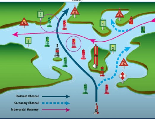
Remember that red ICW markers are always on the mainland side of the channel.

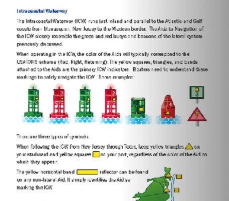
Remember that the ICW markers will be the only markers with the extra yellow reflective square or triangle symbol on them located above the number on the marker.

Remember to look behind yourself frequently to make sure you are really lined up with the markers and truly in the channel and to see if there is a faster moving vessel coming up from behind you.

Use Active Captain, Cruiser's Net and The Loop List for fairly up to date information. But take it all with a grain of salt. :)

Be proactively courteous so you get more waves than fingers.

Call marinas early in the day to reserve your slip. And sometimes you'll get a slip where one wasn't available if you mention you'd like to buy some fuel from them as well.
 
This is the chart book I use. Convenient size, easy to flip pages. As you read ahead each day and learn of trouble spots put a notated yellow sticky note next to the area.

The Intracostal Waterway Chart book: Norfolk, Virginia, to Miami, Florida

Right on about the red being on the land side. That is true in all but a few places such as the Cape Fear River. The big things to look for are the gold triangles and squares denoting the ICW markers. The gold never changes sides. The gold triangle is always the land side no matter if it is on red or green.
 
True. And if the yellow symbols are on day shapes or can and nuns they will match the shape of the marker they are on.
.

Capt. Bill, I know you are a very experienced mariner, but I think this is not always correct. When the ICW travels along a returning from sea channel toward the sea the green markers will be on the starboard side going south. They are to be considered a red for the ICW and will have the gold triangle on them. Red is considered a green ICW marker with the gold square on them. The converging channels I can think of are at the Cape Fear, Panama City, and for a short way at Pensacola Pass. Just something to watch out for.
 
Coming into Panama City from East Bay as you go under the bridge the markers change. If you take the Green daymark on your port there is trouble. A very shallow shoal covered with oysters is there. It will play hell with your running gear and the bottom of your boat. It has the gold triangle on the square green day mark. It has caught many boats.
 
In addition to Don's good advice, if you're using a chart plotter, I'd suggest not blindly trusting the magenta line, which often doesn't reflect current conditions. There were a few places on our trip that the line would put you squarely on shoals. We found that paying attention to the nav aids was a lot safer.
 
Here's one I learned that I wish someone would have told me years before I realized it...

Never pull into a marina after 2:00 pm. In fact, try to not pull into a marina after noon. Take an intermediate stop, anchor out the night before, or make shorter hops. If you do that, you'll have an extra day (and maybe your only day) to really spend at the facility.

A corollary to that is to go shorter distances each day. We use to plan on 60-80 nm days every time we moved. Then we reduced that for 50 nm. Today, a 35 nm day is a long one. 20 miles is nicer. We have an occasional 45 or 50 but we try to make them rare. I wish it hadn't taken me about 9 years to realize that.

That's advice I'll take now instead of waiting the 9 years to have the same realization. Capt. Bill's advice about looking back at the last marker to align yourself in the channel is one I learned about the hard way. And thanks, Don, for noting that little switcheroo of marker colors at Panama City. I'm noting that on my chart book right now (for the Admiral, of course).
 
The ICW yellow marks that don't match the main marker color are a ot more common than just a few places...potentially every place the ICW crosses a major rive/inlet system there's a possibility one of the river marks may be on the side of the ICW to warrant an opposite marking.

The philosophy is if following the ICW ignore color and just look for yellow shape...of course 99% of the time the daymark colors are fine...but you better either know or have backed it up with a glance at a chart.
 

Attachments

  • chart.jpg
    chart.jpg
    95.8 KB · Views: 110
Last edited:
The yellow shapes mark the ICW but they are very hard to see from a distance.

I pre-plan my routes using Garmin's HomePort software and then upload the routes to my plotters. Then it's just a matter of following the line on the plotter.

I will say this though before someone else feels the need to point it out:

What you actually see in front of you comes first, then the markers and then the route shown on the plotter. There are places on the ICW where your plotter may show your boat on land next to the canal or river.
 
Yes, look for the yellow shapes on any color day mark or buoy when crossing another channel. You can and will have opposing color/shapes depending where the ICW crosses other channels. What is often a problem is when a "private channel" intersects and they have placed their red or green markers near the ICW.

Also, when available USE RANGE MARKERS I have found them to be one of the best aids when available. Day or Night. If the lower range light is to the left of the upper steer to port, likewise if the lower range is to the right steer to Starboard if you can line them up you are good.

If you meet a Coast Guard vessel tending the aids feel free to contact them on the radio and find out the direction they have been working and any changes they have made. That is usually the most up to date information that you will ever find.
 
Ron:
There are places that my chart plotter did indeed show me on land next to the waterway. The chart plotter was right.
 
........... Never pull into a marina after 2:00 pm. In fact, try to not pull into a marina after noon. Take an intermediate stop, anchor out the night before, or make shorter hops. If you do that, you'll have an extra day (and maybe your only day) to really spend at the facility.............

That's true if it's a "destination" marina or town but not if you're trying to make time or get to somewhere else. Some marinas aren't worth staying at for a day.
 
Some marinas aren't worth staying at for a day.

Then you should feel super comfortable anchoring somewhere. If the marina isn't worth it, there's always a better alternative. Save the money for the marina that is worth staying at.
 
That's true if it's a "destination" marina or town but not if you're trying to make time or get to somewhere else. Some marinas aren't worth staying at for a day.

Correct, Ron. That is for our type of cruising. I think live aboard cruising is totally different. There may be no destination just the cruise. The way Jeff does it is ideal. That's more like what we do when getting to the Keys, Bahamas, or Chesapeake. We cover distance then slow down to enjoy the area at a leisurely pace.

I have always thought I would like to cast off the lines, and do it as Jeff does. I have had to reconcile that due to circumstances it will probably never happen. Hey, this ain't so bad like it is. In fact, I really like it.
 
Capt. Bill, I know you are a very experienced mariner, but I think this is not always correct. When the ICW travels along a returning from sea channel toward the sea the green markers will be on the starboard side going south. They are to be considered a red for the ICW and will have the gold triangle on them. Red is considered a green ICW marker with the gold square on them. The converging channels I can think of are at the Cape Fear, Panama City, and for a short way at Pensacola Pass. Just something to watch out for.

Yes. But I believe if the marker is physically shaped like a triangle or square day shape or tapered like a nun it will always have the yellow symbol match the shape. If the marker is a standard buoy with a squared off top it can display either the yellow square or triangle regardless of what color it is.

See the nav aids booklet I attached the link to.

At least that is the way I remember it. But of course my memory could be playing tricks on me. :D
 
Then you should feel super comfortable anchoring somewhere. If the marina isn't worth it, there's always a better alternative. Save the money for the marina that is worth staying at.

There are times when you are hot and tired and need/want air conditioning and a long shower or just need to get off the boat for a while (or your dog does). You might be low on fuel or water. You might not be near a suitable anchorage.

There are no rules, we each do it the way that suits us. I have done what you suggested and I have done it the other way, whichever seems best at the time.
 
Page 25 of that booklet does lead one to believe that if the ICW mark is on a shaped buoy...it will be the same and that makes sense...then the next sentence ways look at the yellow mark and not the color of the primary aid...

Best to just check the chart if in doubt....

http://www.uscgboating.org/ATON/index.html
 

Attachments

  • chart2.jpg
    chart2.jpg
    104.5 KB · Views: 88
Last edited:
Yes. But I believe if the marker is physically shaped like a triangle or square day shape or tapered like a nun it will always have the yellow symbol match the shape. If the marker is a standard buoy with a squared off top it can display either the yellow square or triangle regardless of what color it is.

See the nav aids booklet I attached the link to.

At least that is the way I remember it. But of course my memory could be playing tricks on me. :D

Maybe there is a semantics issue. You see a yellow symbol different from the navaid it is on when the navaid is marking a an inlet from the ocean. So as you cross the inlet say from east to west, the red buoy will have a yellow triangle on it, and the green also a yellow triangle. As far as them being visible, a good pair of binoculars is much more important (and less dangerous) than a chart plotter for cruising the ICW.

I just went through a mental tour of the ICW and cannot recall anywhere there was not a viable anchorage, even for a boat our size, within 10 miles of a marina area, and usually well within five. It gets a little dicey in urban south florida, but then you have a number of choices of marina quality to pick from. Anchoring out, even taking a mooring, is the best way to save money (though not as much as one may think if you have to run the genset all day), along with eating on the boat. For us, it wasn't a money saving proposition as much as it was our life style preference; anchoring being our main reason for cruising. Otherwise we'd just take a car and/or an airplane.

Jeff: Skipper Bob was offering the advice on when to go to a marina at least 10 years ago, if not more. In early, out late.
 
Last edited:
We generally do dock at marinas rather than anchor so some follow up to the comment earlier about getting there early.

First, when cruising we've fallen into a schedule where we generally leave the dock around 7:00 AM. That generally, but not always, gets one the calmest part of the day, the coolest, and the least congested. It also does have the benefit of getting one to the next destination earlier or covering a greater distances. Getting to a destination earlier does two things. It might help you avoid docking issue, but more, it allows you to enjoy the new stop that same day.

Now, as to 2:00 or noon, I'm assuming that he's referencing getting assigned a good slip. Places that are crowded and don't take reservations that is definitely an issue. Same issue in crowded anchorages. However, the vast majority of marinas do take reservations. We always follow up on ours too, the day before. Plus we touch base with the dockmaster while on the way. We let them know our expected time and let them know if anything is changing. Then rather than pull up to the dock waiting for help, we contact as we head in so they can be prepared for us. We have the marina pulled up so if they describe the dock and slip we can visualize it. That way there is no wondering where we're supposed to go or the space being too small. 95% of the time as a transient we end up with side tie. The more you communicate, the nicer you are, the better things will go. Plus then return trips are even easier.

But then we don't go for the cheapest dock either. Often there is a reason it's cheap and the spot you get assigned is too shallow or has boards sticking out or other issues. Doesn't mean the most expensive. Do some research on the marinas in the areas you're headed. We've docked between 400 and 500 nights in the past two years and 99% have worked out well. We've not found more than 8 or 10 areas in which we realized in advance the marinas were inadequate. Those are the times we've anchored. We've also gotten many referrals from one marina to another later on the trip or from other boaters and using those often opens doors quicker.

It is worth the time to study the areas you intend to cruise and study the marinas and anchorages in detail. Use multiple sources. That way there will be no surprises. And it won't be so important what time you arrive. We've arrived at several after hours but never without communicating with them in advance and almost always without problems.

Be careful how you describe your boat too. A Grand Banks 53 is not 53'. It's 58' with a 17'9" beam and 4'9" draft and for expedience I'd describe as 58', 18' beam, 5' draft. But you say a Grand Banks 53 and you may well get sandwiched in a space you don't fit. With platforms and pulpits many boats are now 5' or more beyond their stated size. A Fleming 58 is 65'5".

We've found time at marinas to be pleasant 98% of the time. But then we were prepared. The marina that had a bar on the dock open until 2 AM didn't surprise us. Or the one by the train track. Or the morning ferry traffic.
 
Jeff: Skipper Bob was offering the advice on when to go to a marina at least 10 years ago, if not more. In early, out late.

I knew Bob personally. We lost him too soon - he had many gems to share that came out of many years and miles of cruising.
 
A little story. Sorry for the drift. I was helping a couple that had no saltwater experience take their spanking new Heritage East trawler from Clearwater, FL to Orange Beach, AL. This was before chart plotters. I was doing the charts, and warned my "captain" about the change in markers as we went into the ship channel under the bridge at Panama City. He said that he had taken boating courses, and never heard of such a thing. I told him that if he didn't honor that he would damage his boat. He said he would do it if I would take full responsibility for what happened. Not wanting to spend several hours aground, I said I would.

When we went by the first green daymark on our starboard side a Carver cruiser was almost sitting out of the water tilted to one side. They didn't indicate they wanted any help, so we went on the PC Marina for the night. We went to dinner, and went to bed. About midnight we heard a loud noise. There was metal hitting metal and a lot of shouting. They tied up in the slip next to us. It was the Carver, and the wife by her very salty language was not very happy with the whole thing. In fact she said she would never get on the boat again.

We helped them get tied in. My "captain" says to them, "didn't you know the markers change colors as you come under the bridge". They just glared at him. I just went back to bed. One more day and I would be off the boat.
 
I knew Bob personally. We lost him too soon - he had many gems to share that came out of many years and miles of cruising.

True indeed (you should have listened to him ;o) !), though he also had a tendency to dole out some bad advice, the worst of all emphatically telling newbies they should not bother cruising New England! And some not very practical advice, such as always anchoring with two anchors off the bow. I'd still recommend his "cruising on a budget" book for a reference, but not a Bible.
 
Back
Top Bottom