Issues with the Navionics Web App

The friendliest place on the web for anyone who enjoys boating.
If you have answers, please help by responding to the unanswered posts.

ahoy

Member
Joined
Mar 7, 2020
Messages
9
Location
Pacific Northwest Canada
Vessel Name
Miss Teak
Vessel Make
1981 36 Grand Mariner
Has anyone noticed what's going on with the Navionics web app lately? I've invested in both the iPhone app and an SD card for my chart plotter, and I frequently use the web app. But now, with the transition to the new Garmin site, it seems like the Navionics web app is gone and everything is really disorganized. Any insights or solutions?
 
No insight, but have noticed the same. Being able to look at the charts on a PC was something I used often. But yep looks like it is gone now!
 
There is a thread on CruisersForum noting the same, specially lamenting inability to interface with Garmin chart plotter. Personally, I use Coastal Explorer and save the route as a GPX file which can be easily imported into Navionics App. I assume a Garmin chartplotter has same import function.

Garmin has an interesting business model in that they seem to purchase innovative applications and kill them for no obvious business benefit.

Peter
 
That is something I also used to use on PC for trip planning, I also found out the day before a 2 week trip that my tablet was no longer supported by Navionics.

I am definitely looking for other options for next season.
 
Their app is still functioning on my phone and tablet. I've been using it for route planning.
Yes, my tablet is a 10-year-old Samsung. Tablet works perfectly, but is no longer supported, I need to replace with a more recent operating system (OS 7.0 or higher.) I did use it on my phone for the trip and planning.
 
The issue as I understand it is Navionics used to have a web-based application where you could plan on your PC and the routes/waypoints transfer to your account/App (tablet or phone). If I understand correctly, the PC-based functionality has been terminated by Garmin. The Navionics App via Phone/Tablet works fine.

Peter
That clears things up for me. I have Navionics on my I pad. I use this for planning perposes.

I got the app under a free trial. After the trial period I lost some features like auto route but the features I needed still functioned. One day while sitting in a hotel room with nothing to do I started down loading charts. I managed to down load all of the US and Canada with the exception of a few rivers and the center of the NW Passage. I tried to download the rest of the NWP but the app no longer allows me to down load maps.

While this is disappointing to me, it is certainly fair as I have never paid for the app. The app is always asking me to renew my subscription. I suspect that if I did that I would get all the functions back.
 
Thanks @Portage_Bay.
I submitted this following to Garmin support:

Hello Garmin,

I am currently planning my next boat trip and am unable to locate the Navionics chart viewer on my PC. The new website interface is quite confusing. While I understand and appreciate the need for updates, this change has been overwhelming.

Could you please direct me to where I can access the previous Navionics web app?

I have paid for the Navionics web app twice—once for the iPhone app and once for the Chartplotter SD card. I am eager to use the services I have purchased.

I look forward to your prompt response.

Best regards,
 
I lament the loss of the Navionics Web App Chart Viewer too. It was great for planning trips while sitting at the desk at home.
I have discovered this link takes you to something similar, but not quite as good. In particular, no dividers.
 
Thanks @Portage_Bay.
I submitted this following to Garmin support:

Hello Garmin,

I am currently planning my next boat trip and am unable to locate the Navionics chart viewer on my PC. The new website interface is quite confusing. While I understand and appreciate the need for updates, this change has been overwhelming.

Could you please direct me to where I can access the previous Navionics web app?

I have paid for the Navionics web app twice—once for the iPhone app and once for the Chartplotter SD card. I am eager to use the services I have purchased.

I look forward to your prompt response.

Best regards,
I was a bit more blunt. I told Garmin that dropping their web app was a poor business decision. In less polite words....
 
I was attempting to plot a trip from south of Ottawa to Belleville Ontario. It couldn't be calculated on my ipad version of Navionics, so I tried to Kingston instead.
That didn't work either, I suspect both would have been possible with the PC based version. I was hoping to create the route on my PC then download it to the chart plotter via SD card. Back to the drawing board.
 
I just did too. What are the chances these complaints will make a difference?
 
Thank you for contacting Garmin Navionics.

Unfortunately the Navionics website and Chart Viewer were decommissioned July 31st and the Navionics product information, support articles, videos and chart details can now be found on Garmin.com. The new Chart Viewer offers easy to search chart information, map options, coverage details, recently updated locations and more, for all Navionics and Garmin marine charts in one single tool. This new chart viewer no longer contains route planning functionality. Any of your saved routes created from our previous tool are stored on your account and accessible to you through your Boating app by simply launching the app or by selecting “sync” in the app menu.

Route planning continues to be available within our Boating app while under an active subscription. From the Boating app, routes, tracks and markers can be shared across your mobile devices, Garmin & 3rd party chart plotters by way of export/import of GPX files as well as other Navionics Boating app users with the app sharing feature. Sync routes and markers directly from your Navionics Boating app to your Plotter Sync compatible unit. If you are looking to continue using your computer for route planning purposes, you can find more information on compatible PC Planning Software tools in our Compatibility Guide.

If you have any questions and or issues, please feel free to contact me.
Best regards,
Finn
Navionics Product Support Specialist
My subscription just ran out and I will not be renewing of course since there is no product similar.
Notice the embed link to the new Chart Viewer does not actually go to a chart viewer. The embed link to compatibility Guide does not include Raymarine chart plotter I have.

This may explain why I have failed to install a 1.3 GB file downloaded for an update.
 
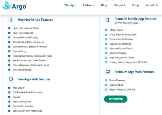
Argo could be a viable option, it's kinda of a copy of Navonics with some different features. I saw them at them at the 2024 Seattle Boat Show. I tried the free app this spring and it was okay but I preferred Navionics. Argo states they have a web based chart viewer that does routing with the $20 paid option. I like to plan on my PC that is set up with 2 screens, so losing the web based Chart View from Navionics is a set back for me. Below is a screen shot of Argo features. I have no connection with Argo, I am just looking for options. Here is the Argo link Argo | FREE Navigation & Social Boating App | Download Today!
 

Attachments

  • Argo.jpg
    Argo.jpg
    82.6 KB · Views: 22
Just found out a couple of days ago that Navionics does not work anymore on the laptop. I do have a subscription on the tablet, so they better not cancel that one.
However, I have seen that next year it will be over for me. They have raised the prices by 500 % for the region I am in and that is a no go.
Only problem I have is that my Raymarine uses Navionics charts as well and I am not going to pay 250 euro every year for a few updates. In that case I will forget the updates, there is not a lot changing in the area where we are sailing. It is not that all of a sudden some rocks start to pop up out of the sea.

But must say that it bewilders me why company executives have so little understanding of their customers. Now Garmin is killing off the goose with the golden eggs, for no other reason than pure greed. Not a wise decision.
Unfortunately Argo does not work in Europe.
 
I loved GARMIN products at first, I stopped using GARMIN products years ago when I realized they are a bait and switch company, basically they made very reliable hardware and chart plotters then after a few years they stop supporting the units, they do this all the time with their aviation products as well. Total greed, somehow they get away with it. I have wondered for years how they have been able to avoid any consumer protection actions? Someone is getting paid big money to cover for them. Maybe they will have second thoughts? Not a chance they only seek to drain people's wallets many times over knowing they can and will get away with it.
 
This is not limited to NAV software and hardware.
Microsoft business plan is being copied, or vice versa. I have had a PC with windows since windows 95. Recently I decided to fire up an old computer with win 98SE and ran it beside the newest win 11. It was just as fast to respond to my input albeit the programs are not the same.
Windows 10 skipped win 9 with a good product that was updated until it wasn't good. Updates introduce faults so you have to buy the newest, hidden by a different desktop, different colors, same software.
 
ASFAIK, the Navionics PC program was terminated quite a while ago. They did have a web app, but you couldn't download a .gpx file, so it was pretty worthless.
I use MacENC, but also OpenCPN (which is very full functioned and free) to set waypoints and do route planning, then transfer to Navionics on my tablet and to my Raymarine MFD. Also transfer to Windy to do weather route planning.

Jack
 
I used the Navionics web browser interface within the last couple months to create routes that were available in the Boating (aka Navionics) apps on my iPad and iPhone. Very handy and a real loss to the functionality of Navionics. I will be doing an electronics upgrade soon that includes two Garmin GPSMAP MFDs. Hoping I don't have to start over now...
 
I chatted with a Garmin.com rep who confirmed that while the route planning feature at Navionics.com has been removed, route planning tools are still available at Active Captain. The catch is that your Active Captain account must be linked to at least one chartplotter that has an active chart subscription. That all came as quite a shock to a guy who has been using Navionics on an iPad for $15 a year.

Do other chartplotter and MFD platforms like Raymarine and Simrad have similar annual chart subscription costs?
 
My Raymarine MFD’s are probably 20 years old. They actually use CF cards. I have never updated the Navionics cards. My position is that rocks and islands never move. Buoys change colors and move but my situational awareness notiCEs These differences immediately.

I have Navionics on my iPad. I paid for the first year, downloaded all of US & Canada. After a year I didn’t renew the subscription. I have since lost ability to down load charts and the auto routing feature was disabled.

Frankly, I understand the auto routing being disabled. With out current charts Navionics could get blamed for some sort of mishap do to moved marks.

I continue to do planning work on the I pad and manual routing works fine. In fact, I would never trust auto routing with out manually inspecting anyway.
 
I agree that on the chart plotter it will not make a difference without a subscription for updates in familiar waters.
The PC planning was very helpful, the app on phone is OK too when you have to look at a small screen.
 
Back
Top Bottom