I googled it , and got the 900 mile figure. What did you get? But sure, you could be like the guy with his admitted, imagined route....NORTH of Greenland.
You started this thread asking about recent NW Passage transits and stated the need for 30 - 40 permits. In your post
#6 you were calling the NW Passage international waters and the requirement for permits piracy.
In post
#10 I attached two maps. One showing Canada and the other showing typical NW Passage routes through Canada. There is no one right NW passage route. You will need to adjust your route to avoid ice and weather.
You continued to call the NW Passage International Waters so I tried again in post
#24 that time showing an approximate route that would keep you in international waters.
Now let me break this down for you.
The islands north of the Canadian continental mainland are the Arctic Archipelago. With the exception of Greenland they are part of Canada.
They have been under Canadian Jurisdiction since 1895. To pass through those islands is to pass through Canada.
Further to ignore Canada's boundaries and claim that passages through the Canadian Arctic Archipelago are international waters look to internationally recognized zones of the sea.
The territorial sea recognized by the majority of seafaring nations, including Canada, the US and Russia is from shore out to 12 nautical miles. In the territorial sea a nation has sovereign rights over those waters. When passing between two land masses of a single nation state that are 24 NM or less distant from each other you are in that nation's territorial waters. This alone makes the argument the much of the waters through the Canadian Arctic Archipelago International Waters moot.
Territorial Waters - Wikipedia and
The Territorial Sea and Other Maritime Zones
Next are the Contiguous and Exclusive Economic Zones where nation states have less authority. See the links above.
Further is the need to study the
Canada Oceans Act where Canada defines her territorial, contiguous and exclusive economic zones.
Understanding the above references puts the accepted NW Passage routes well within Canadian waters.
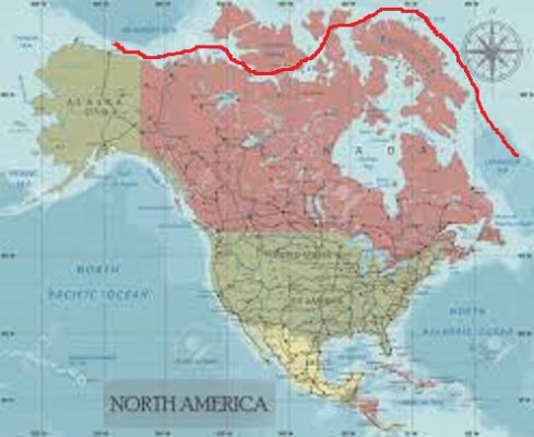
To stay in international waters you must travel north of the Canadian Arctic Archipelago. Traveling west to east, at the eastern end that now puts you approaching the NW tip of Greenland. The narrowest passage between Greenland and the Canadian islands is under 12 NM as measured on Google Earth. You must travel north around Greenland to stay in international waters. East to west would be no different.
Because nations such as the US and Russia want to dispute the International Waters status of the NW Passage does not make the NW Passage International Waters.. It is a dispute until settled. To say Canada is committing piracy by defending in her views her rights is at best arrogant nonsense.
Hopefully it is now clear to you that what I and others have said. The NW Passage goes THROUGH Canada.
Would it be too much trouble to apply for the proper Canadian permit? And where do you get the idea you need 30 - 40 permits? I have in my career worked extensively in Canada on a US boat. I have found that one doesn't need permits from First Nations peoples. One should contact them, and respectfully ask to travel their waters. If arrogance and ignorance are left out of the communications all is well.