paper charts

The friendliest place on the web for anyone who enjoys boating.
If you have answers, please help by responding to the unanswered posts.
I bought my first boat, a 28' sailboat in 1982. I learned navigation with charts and rulers in 1979. In my present boat, a 42 Trawler I have a networked Raymarine system on the flybridge and the lower pilot station.

What I also have is a full set of charts in the areas that I will be traveling. In addition I have depth sounders that are independent of my charting package. So, if my Raymarine system fails, I break out the charts, hang my hand bearing compass around my neck and sharpen my pencil.
 
At least for me no intention to put anyone down.
With that said I have to say on AVERAGE I find a higher level of incompetence with those that have never bothered with paper and believe electronics is all thats necessary vs those that have used paper and don't bother (much) with electronics.
They are both beneficial and have their place IMO but the screen can be a crutch that hinders learning for some

I think that is such a broad generalization as to be nothing but dangerous. It fails to take experience into consideration and even things like age and when trained. It would be like me saying those who started with paper charts are less skilled with electronics. True for some, false for some.

As to your generalization, I don't fault any users of paper, but I do firmly believe all that is needed is electronics so I fit into your higher level of incompetence on average group from above and I don't appreciate that, nor believe it.

I don't grasp why preferring paper or preferring electronics automatically makes one superior.


I didn't read his comment as demeaning...

And I too would guess that if you polled many relatively new boaters you'd find many don't actually know how to plot a course taking set and drift into account, etc... because they only learned how to aim the boat at an on-screen waypoint...

Very likely not the population here... but then I don't know that the population here is representative of the worldwide mass of boaters.

-Chris

This population certainly isn't typical. However, chart or electronics, a lot of newer boaters have never considered drift. Many don't look at currents. Part of that is they have semi planing or planing boats and can get by without it. On the other hand, sailboaters sometimes are more diligent in that regard but then they deal with wind. I'd say when those of you who are now older were young, there were many your age who did a poor job of learning navigation skills. People didn't get smarter or dumber as time passed or more or less diligent. Unfortunately some percentage of the population has always just taken off and gone and been undertrained and careless. I use to see so many newly purchased boats run aground on the lake and you see them regularly on the ICW today. They aren't paying attention to paper, to electronic or to vision.

Before we're too tough on recreational boaters though, let's not overlook the megayachts that have sunk or run aground or caught fire, nor all the Navy vessels that have had issues, nor all the cargo ships to lose containers. The worst among us never learned anything and the more dedicated learn something new every time they go out.
 
"Yes, and since China itself doesnt want to be returned to the dark ages, it will be careful not to take any chances that will happen. Its why the ' mutually assed desteuction ' policy has worked so well, so far. In any case , Chinas more subtle policies have been working very well in their favor."
user_offline.gif


Its my understanding that a nuke in orbit would wipe electronics in the line of sight of the device.So there is no chance China would blind itself . A rogue nation ship would conduct the launch , leaving no trail back to any country.

The nav. gear needed to make a harbor would be paper charts, a hand bearing compass , a depth sounder and perhaps ,some sort of AM radio .Stuff most folks have already , but learning to use them to navigate requires both understanding and practice.
 
Last edited:
....and I repeat what I said earlier. If we are in an all-out war with China or another powerful nation, navigation for recreational boaters is the least of your problems. Not sure why this is even part of the discussion.
 
"Yes, and since China itself doesnt want to be returned to the dark ages, it will be careful not to take any chances that will happen. Its why the ' mutually assed desteuction ' policy has worked so well, so far. In any case , Chinas more subtle policies have been working very well in their favor."
user_offline.gif


Its my understanding that a nuke in orbit would wipe electronics in the line of sight of the device.So there is no chance China would blind itself . A rogue nation ship would conduct the launch , leaving no trail back to any country.

The nav. gear needed to make a harbor would be paper charts, a hand bearing compass , a depth sounder and perhaps ,some sort of AM radio .Stuff most

You make the unfounded assumption that a rogue nation could do that, and that it wouldnt get caught. Very unlikely on both counts. If such a thing were so easy to do, some of americas many enemies would have already tried it. None have.

There have been disruptions to the GPS service. Suspected electronic interference by nations testing such equipment. The US military it was suggested electronically moves a spot around to prevent pin point targeting.
HERE is a link to a glitch in the software.
If you have an anchor watch GPS turn it on when tied to a dock and watch you boat move about.
 
Selective availability by the US military was stopped I believe back under President Clinton.

Errors in GPS accuracy occur form sever natural natural occurring interferences as well.

Localized by "spoofing" happens, and is not really hard to do,, but really is a rarity.
 
Selective availability by the US military was stopped I believe back under President Clinton.

Errors in GPS accuracy occur form sever natural natural occurring interferences as well.

Localized by "spoofing" happens, and is not really hard to do,, but really is a rarity.

So from all out war with Cina, to renegade statesxlaunching from ships, to.....localized spooofs and the USN testing out stuff. ill stick to the modern electronics, and keep my world atlas and compass on hand just in case.
 
So from all out war with Cina, to renegade statesxlaunching from ships, to.....localized spooofs and the USN testing out stuff. ill stick to the modern electronics, and keep my world atlas and compass on hand just in case.

Yes, I'm not going to base my decisions on Armageddon or any other doomsday scenario. If such scenario happens, no choices I've made are going to matter anyway. I never understood what all those building bomb shelters in anticipation of a nuclear holocaust thought they were going to return to or when.
 
Bomb shelters like students hiding under the desks were meant to keep casualties off the streets and buried in rubble along with public other "feel good" things.

Like many events that cause panic or public misunderstanding, the public is fed info to placate and keep control.

Not necessarily right.... but better than the alternative. Look at concerts and soccer games to understand out of control crowd behavior.
 
Yes, I'm not going to base my decisions on Armageddon or any other doomsday scenario. If such scenario happens, no choices I've made are going to matter anyway. I never understood what all those building bomb shelters in anticipation of a nuclear holocaust thought they were going to return to or when.

Quite right
 
Setting aside the doomsday side and returning to utility of paper charts in a digital world, I was on a friend's boat last night as we entered San Diego from Ensenada. Final destination was Chula Vista which is 8 nms south in a channel that serpentines in the last half. Running at night is not ideal but sometimes it happens. You get used to it after a while.

My friend set a course route on his plotter and followed it closely which is fine, but I found it more relaxing to also view the paper charts as there are often patterns to the lights which are much easier to detect in a large format and where each light sequence is printed (vs having to click the ATON to bring up the description). Knowing what you're looking for greatly assists filtering channel markers from background city lights. For example, pattern last night was flashing red 4-seconds for most, flashing 1-second for hard dogleg turns of the channel. This made navigating easier as it could be done via a combination of visual (radar to 'see' ATON until visual can be established) and electronic. Ultimately, meant less time looking at a chart plotter and more time looking at radar and out the window where uncharted obstructions could be detected such as oncoming or overtaking traffic.

My point is that for those who keep charts as backup, you're missing a lot. They augment electronic navigation nicely.

Peter
 
Last edited:
Setting aside the doomsday side and returning to utility of paper charts in a digital world, I was on a friend's boat last night as we entered San Diego from Ensenada. Final destination was Chula Vista which is 8 nms south in a channel that serpentines in the last half. Running at night is not ideal but sometimes it happens. You get used to it after a while.

My friend set a course route on his plotter and followed it closely which is fine, but I found it more relaxing to also view the paper charts as there are often patterns to the lights which are much easier to detect in a large format and where each light sequence is printed (vs having to click the ATON to bring up the description). Knowing what you're looking for greatly assists filtering channel markers from background city lights. For example, pattern last night was flashing red 4-seconds for most, flashing 1-second for hard dogleg turns of the channel. This made navigating easier as it could be done via a combination of visual (radar to 'see' ATON until visual can be established) and electronic. Ultimately, meant less time looking at a chart plotter and more time looking at radar and out the window where uncharted obstructions could be detected such as oncoming or overtaking traffic.

My point is that for those who keep charts as backup, you're missing a lot. They augment electronic navigation nicely.

Peter

Yes, some find some things "more relaxing" than others. In that same are what does the USCG, or Harbor police find most relaxing?
 
Good point above about light characteristics being important and easier to discern on a paper chart rather than an MFD.

However I find the Light List to be an invaluable addition to my navigation. The Light List is a pdf and easy to download. It can be extracted into a small number of pages that would cover the navigational area of interest. Usually the lights for a given channel are in order and easy to follow.
 
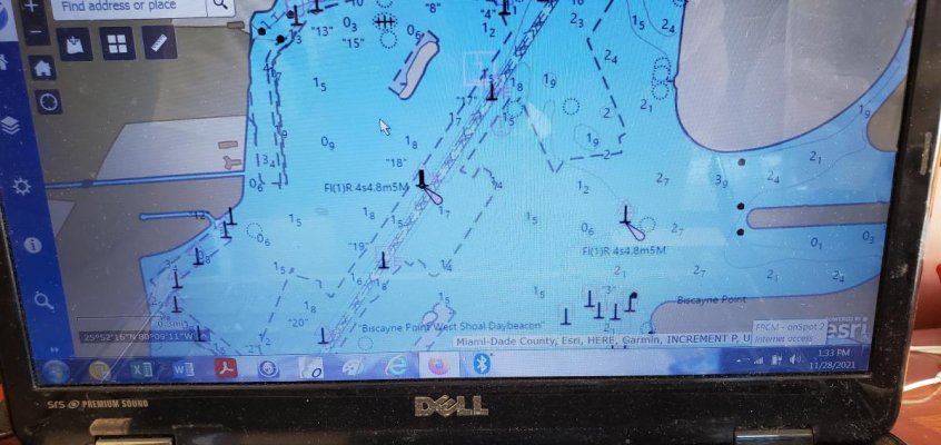
I just viewed a real NOAA (obviously approved) vector chart and it had pretty visible lighting characteristics on it under normal viewing running the ICW.
 

Attachments

  • 20211128_133304.jpg
    20211128_133304.jpg
    104.8 KB · Views: 42
I just viewed a real NOAA (obviously approved) vector chart and it had pretty visible lighting characteristics on it under normal viewing running the ICW.
Thanks. Much better than the vector charts I've used. Frankly, I've had trouble getting the settings correct to filter a desirable amount of clutter.

Very helpful. Appreciate the screenshot.

Peter
 
As I posted back in post #33, many posters are used to bad chartplotters.


Many are just used to poor charting software, outdated MFDs and some just misguided or wrong info about electronic charts as a whole.


I get the whole allegiance to paper charts...I had it for a long time too. But other than preference...I just have seen the reality that paper's advantages are only just that.


Excellent navigators prove it every day...but you have to have the right tools, experience and desire.
 
Paper is a MUST. :)

If you suddenly sink your electronics will fail, and your PAPER chart will float up. :)

You did mark you position on your PAPER chart at the top of each hour didn't you :)
 
All the paper maps I have for flying get used for xmas wrapping. Everybody loves them. Could probably do the same with nautical charts since they're mostly being discontinued.
 
The paper vs electronic chart topic just matches almost everything else in the boating world....personal preference. Same with hulls, sail vs motor....induction/gas stoves, anchors, plumbing, heating, windows, etc.
 
You did mark you position on your PAPER chart at the top of each hour didn't you :)

That's funny. You wonder how many people actually log their position into their log books at the top of each hour, even if they don't mark it on a paper chart.

So if the electronics go down (plotter, gps, iPhone Navionics) out of sight of land, and you pull out your paper chart, how do you know where you are to start your track?
 
Last edited:
Paper charts

We recently. Navigated through the panama canal may of 2021 one requirement is to be measured and prove certain safety items are onboard . one item requested were paper charts of the area. I did have such charts given to me by a veteran of cruising for nearly 30 years. I took his roll of charts that he offered to me in la paz glad I did not sure they would have rejected the boat if I did not have them I have 4 separate chart plotters plus I pad if I get lost. It's because of age not navigation devices
 
Sigh. "Some" of the arguments that are "must" and "always" oriented are silly. Why not just become familiar with all the tools available, and use the one most comfortable in the circumstances?

When I make furniture, I prefer to cut mortise joints with mortising chisels and dovetail saws. But I also use a power drill. And use a powered bandsaw to blank out queen anne legs. I use both power as well as hand tools.

I am old enough to remember and to have used the first PC's. A friend proudly pointed out you could use Lotus 123 as a word processor. My response was, why would you want to, because WordPerfect can do it better. (All pre-Word and pre-Excel).

If you don't like paper charts and don't see the value, then free up the clutter and ditch them. If you don't know how to use a mortising chisel and drawknife, get them out the shop.

I grew up boating when there were no MFD's. I navigated by chart and compass. But I'm now shopping for an electronics package for my new build, and it appears installed that pretty much every brand's package will cost about $35K. Where a good compass is $1k or less, and a collection of charts that much or less. This is called progress. But I'm doing it. Its better. I didn't have radar back then but now I will. There was no AIS but now there is. And so forth.

But I'll also be getting a reasonably compact chart book and compass. Because at the cost, why not?

But if you don't know what to do with charts and compass, don't see the value, or don't care to use them, then just don't.

Its not complicated unless we make it so.
 
All the paper maps I have for flying get used for xmas wrapping. Everybody loves them. Could probably do the same with nautical charts since they're mostly being discontinued.


Yes, great use for them. Did the same, but ran out years ago. And I don't give out Christmas presents any more... that's gone electronic, too.
 
Buddy of mine makes Christmas tree ornaments out of them. They get cut into sails and glued to twigs as little sailboats.
 
Great reply FWT. I'm of the same ilk Born before computers , and calculators, and in the time when using Slide rules during exams at college was banned. I use the head up monitors and mini computers, with all sorts of electronics. But also carry charts, maintain a hourly log, carry a sextant and tables etc. Crossed oceans before GPS, Satnav etc. Had 2 fires at sea, lost battery power mid ocean. So done a fair few miles. Would I rely solely on electronics? Not a chance, it maybe alright along the coast, so you can always nip in if you have a problem. But I use all available info and materials to find my position at sea.
 
Great reply FWT. I'm of the same ilk Born before computers , and calculators, and in the time when using Slide rules during exams at college was banned. I use the head up monitors and mini computers, with all sorts of electronics. But also carry charts, maintain a hourly log, carry a sextant and tables etc. Crossed oceans before GPS, Satnav etc. Had 2 fires at sea, lost battery power mid ocean. So done a fair few miles. Would I rely solely on electronics? Not a chance, it maybe alright along the coast, so you can always nip in if you have a problem. But I use all available info and materials to find my position at sea.

Great post. Perfectly sums it up.

I guess I'm turning into a grump old guy. :)

A realtor once explained to me a big dynamic in home sales. It turns out fewer "kids" in their 20's and 30's know the basics of home maintenance than we might think. They have no clue how to paint a room, so they insist on perfect paint with nary a touchup needed. The colors have to be colors they would pick. They have no clue how to clip a hedge or weed, so gardens are a turnoff. I dismissed it until later when I had to show my 33 year old son in law what a tire pressure gauge was and how to use it. Ivy League college and Harvard Law. Not dumb, obviously. Just zero knowledge, and intimidated by the slightest thing that's mechanical. But extremely comfortable with all things tech. MFD's would be right up his alley, but he's not a candidate to get value out of paper charts and compass.
 
This is the market MFD companies have to account for.

:)
 
Last edited by a moderator:
Back
Top Bottom