What size chartplotter display

The friendliest place on the web for anyone who enjoys boating.
If you have answers, please help by responding to the unanswered posts.
Poor wording of my question. I get that Navionics (and presumably AquaMaps) connect with NEMA 2000 networks, but I don’t think either will issue heading commands to an autopilot over that network and therefore can not be used to steer a course or series of waypoints.

I believe iNavX will do that, but I have not delved deeply enough into that app to know how it is inferior to Navionics or AquaMaps.

If I were starting over, my choice would be Coastal Explorer. You can run it on a NUC, display it on a 24" flat screen, and interface it to NEMA 2000 for well under $2K. You could buy a Koden radar and interface it through Coastal Explorer where CE will allow the NUC to display on 2 monitors, one for navigation and all NEMA 2000 information, and the other for radar.

Ted
 
Poor wording of my question. I get that Navionics (and presumably AquaMaps) connect with NEMA 2000 networks, but I don’t think either will issue heading commands to an autopilot over that network and therefore can not be used to steer a course or series of waypoints.

I believe iNavX will do that, but I have not delved deeply enough into that app to know how it is inferior to Navionics or AquaMaps.

Assuming the N2K network includes a chartplotter that can control the autopilot, what we do is configure the route on the tablet which is much easier than on the MFD, and email the file to an SD card to import into the chartplotter to control the autopilot route.
I guess if you wanted to you could then control the MFD from the tablet with the MFD mfgr's link software to enable control from the tablet in a different location. But you are correct that natively you cannot run the autopilot from Navionics or Aqua Maps on a tablet.

James
 
Largest that will fit.

Especially if you need to display radar, fish or bottom type... and/or if you need multiple charts (different ranges) at once.

Anything smaller than about 12" probably won't be as useful for split screens.

Amortized cost over time often isn't too bad...

-Chris

:thumb:
 
I just made a 4 hour run through 1/4 mile visibility fog. I was in a new to me area full of broken islands and rocks. I had my radar on my 9" screen and I ran navigation with radar overlay on my 14" screen. The overlay never showed those pesky kayaks. The radar only screen showed them. I can't say how things would have gone if I did a split screen on the 9".

This has been my experience as well. Think people should get in the habit of switching screens and magnification frequently. To my knowledge all branded MFDs allow preset screens. With the bride we switch back and forth between a screen of chart and radar/AIS overlay at harbor at one mag and just radar/AIS at bouy on another when in fog . Also think all current radars can be tuned or filter settings changed. It’s surprising to me how a little squeak improves things. Also use split screens but if I only had small screens would avoid split screens and switch screens more often. Problem we have is I was trained north up. Admiral likes course up. To keep the peace we’re course up except when she’s sleeping. Sometimes I forget to switch back.

Several friends have given up on “big” boats to focus on fishing from center consoles. Sonar and gps fixes are more important than extensive charting. Nav is mostly line of sight as they know their local waters so well. They want to see fish and record when and where they caught them. They get by with a dedicated hand held gps device and a small screen for sonar/depth.
 
Last edited:
One interesting feature is their "Master" upgrade. For $15/yr, gives you AIS, wx forecasting, weather buoys, and some route information.


That also includes the USACE survey overlays, and we've found those to be VERY useful along certain bit of the AICW.

-Chris
 
But you are correct that natively you cannot run the autopilot from Navionics or Aqua Maps on a tablet.

iNavX is the exception, but from what I can see, they have only raster charts. While that may be okay for the autopilot, it would seem to require at least one more screen for better chart data. At least for me.

I know there are plenty who say that an autopilot that steers a course from waypoint to waypoint is unnecessary or even unwise, but I need to find out for myself. My objective is not to go below and make lunch while the autopilot handles the helm, but rather to let the autopilot keep the boat on course while I scan for traffic or crab pots or whatever.

Assuming the N2K network includes a chartplotter that can control the autopilot

That's where I am, without a dedicated chartplotter. I took out an outdated Standard Horizons unit rather than buy new C Map charts believing that a more modern and elegant solution was in the near future. It may or may not be, but the constant march of technology is on my side.

If I were starting over, my choice would be Coastal Explorer. You can run it on a NUC, display it on a 24" flat screen, and interface it to NEMA 2000 for well under $2K.

And that is really where I am. While plenty rely on Navionics running on a tablet, long term reliability for me says a dedicated and hard wired solution is best. While Garmin and Navionics would seem to require only a brief learning curve, it's a learning curve all the same and being somewhat of a geek myself, I am not afraid of Coastal Explorer or such. It is good to have choices.
 
So back to the display size question, I have done fine with the 10 or so inch display on my iPad. Escape is an 8 knot boat and that allows enough time to focus on smaller screens or parts of a screen. I single handed this boat from Grand Haven all the way around Michigan to Sandusky with Navionics running on my iPhone 12 Mini. That's like a 4.6" screen.

I would love a 24" screen and while I could find a place for something that big on the flybridge, there just isn't enough space for that in the Mariner 37 pilothouse.

At the moment, a 9" MFD that is principally a chartplotter makes sense in my limited space.
 

Attachments

  • IMG_1550.jpg
    IMG_1550.jpg
    48.6 KB · Views: 37
The Mariner 37 does not have the instrument ready “box” there that was added to the Helmsman 38. It’s a possibility though.
 
Wow, great info. I appreciate all the opinions. I have decided to treat myself to the 12 inch Garmin screen, thinking of it as a "safety issue" (smile).
It will be in the enclosed pilot station so sunlight not too much of an issue.
As far as cost is concerned , my wife recently gave me a lesson in the value of money, inflation and economics in the form of paying for a new kitchen for her. an extra 1500 for the boat is trivial in comparison.......so it goes.
 
I use a SiTex Navpro 1200 $1,819 at my down helm and a 8 1/2” Samsung Galaxy $129 to mirror the Navpro when I’m up on the flybridge. All I really want to see up top are my depth and course which are easily readable in direct sunlight on the smaller screen.

Trying to use any combination of radar, chart, sonar on a smaller screen is very hard to do. Turns out, size matters!

Tak
 
Last edited:
Sounds like a win-win to me!
 
Here are several reasons I used an iPad Pro with AquaMaps:
1) Maps are updated regularly (weekly?) at no charge.
2) I kept the old installed Garmin system for backup and for autopilot, which I rarely used. I preferred to watch and manually adjust my route.
3) The iPad Pro can be used when docked or at anchor for email, watching videos, etc. No need to bring a laptop or other Internet-connected device.
 
A 12" Samsung tablet with with lifetime software updates for Aquamaps was under $1K.

A 24" HP flat screen, NUC, wireless keyboard, and Coastal Explorer was under $1,200. Adding their Nemo gateway to pick up everything on your NEMA 2000 & 0183 networks was about $700.

Lots of options for a lot less.

Ted


Ted: I’m with you on the Coastal Explorer/NUC/Nemo Gateway thingy. I replaced the old 12VDC computer with N2K converters with a NUC and Nemo Gateway and am very pleased. I use the NOAA and CHS charts, Raster and ENC’s for both. Very pleased with these.

My Green Marine screen died several years ago. According to Green Marine, I could replace it with a newer refurbished unit for about $3,000 USD. Egads! I ended up finding a cheap Chinese 12 VDC monitor for about $200 on Amazon that was the same foot print. Completely adequate. Enough “Nits” for me I guess. It’s in the Pilothouse so doesn’t have to be waterproof. After a year of use, I decided to get a spare, in case this unit died.

Jim
 
Last edited:
We use tablets with chartware programs loaded on. In our case Navionics.

I use two for myself. One is a Samsung Tablet 7" The other is a Samsung 10". Diagonal measurements of course.

Both have actual GPS readers and can also use, if needed the Russian GPS system if available. Look for that as many tablets or cells may depend upon cell towers which is absolutely useless if there are no cell towers in range.
Where we often boat that is frequently the case.

I use both units with one set for long ranges for the overlying view of the shoreline and hazards.
THe second larger one is set for a close up view for the detail. That way I can get different views without fooling around except in the odd circumstance that neither is set suitably.

If I were in the market for an actual plotter , just the one, I would get the largest screen I could afford within reason and the largest I could fit on the dash without interfering to much with other stuff.
 
Bigger is better

There is a reason the "real" chart plotters are so expensive - it is because... they are worth it!

A real chart plotter will be very bright, bright enough to see in the sun. And because it will be hardwired, will never stop working because of a power issue as is sometimes the case with a tablet running at highest brightness.

A real charplotter wont die because of overheating while a tablet in the sun will almost always overheat and shut down in relatively short order.

Yes, a bigger screen is almost always better as long as it fits! Old eyes aside, it is great to be able to see the details from 4-6 ft way.

I have one "real" chartplotter and an iPad Pro at each of my two helms. I went with Garmin (8612 and 8615) as the rest of my hardware is Garmin. I run Navionics and Active Captain on my iPads. This works out pretty well.
 
I am buying a new chartplotter for my Eastern 24 mini trawler

A garmin 9 inch diagonal display is 1500. a 12 inch display is 3000 dollars.
I am old with old eyeballs. I cant decide if it is worth it to pay the extra money for the bigger display.
thoughts?

On my MainShip with dual helms I have a 9” below and a 12” on the fly bridge. I much prefer the larger unit.
 
I am not a rich guy. I have had great eye sight my whole life.

I buy the biggest displays for navigational equipment i can afford. I even put a huge ritchie compass and a 12 inch GOS/sonar display on a 16 skiff since i use it to travel from small islands to the next etc..-

I go out in all sorts of weather, all sorts of places, all times of year. I find that for 95% of the time, a small display is fine (maybe inconvenient sometimes)

But if you are traveling distances, to new ports, islands etc….get as big as you can afford

That 5% of time for me, it could be considered a lifesaver. If your a local travel person thats familiar with the waters you ply, then, IMHO, you can get smaller

Thats just me, my uses, my finances. I would have crappy crappy interior cushions, but the beat navigation equipment.

In any case, good luck with everything
 
Simi touched on need to sequester charts in files - tiles. Otherwise you end up with dozens of bars across the bottom of the screen and the program underperforms. Other nav programs do that for you - and have for years. For US, base charts are the same ENCs available for free.

I am impressed with the dual view Simi shows of satellite and chart. Very helpful. I've tinkered with developing charts from satellite images. I'm sure it's simple once you do it a few times. "A few key strokes" does not come close to describing my early efforts, thus the comments about learning curve.

True, there was some learning curve to get that right but the instructional videos are pretty good and it literally is a couple of keystrokes to master basic screen overlays.

Also, using the programme that has those satellite overlays "SAS planet" allows me to check for best satellite overlays - google, Bing, Nokia, zantrex and several others to get better resolution - it also has Navionics in both sonar chart and standard view plus Cmap.
It's an impressive arsenal for charting in Adventureland and interesting if not down right frightening to see the inaccuracies of Navionics and Cmap versus reality of satellite view

Clearly there are some features in OpenCPN that are cool - weather for example (though that is pretty clunky with an email interface, not unlike the old SailMail/SSB). Last I checked, OpenCPN also was one of the few that made ZoC (zone of confidence) depth data accessible.
How else do you get small sized data packets, short transmission grib files for weather if not by sailmail?

I daresay as Starlink becomes more accepted/available other methods will appear

OpenCPN seems to rely on wonky geeks to improve. They are deep into the nits and don't do much in regression testing to make the program accessible to non-geeks
.

So don't download the next version as it becomes available.
I always wait several months for those more knowledgeable to iron the bugs out.

They preach to their choir who are happy to invest the time to save money.
It's not about saving money for me though that is a plus.
Even if I had the Dashew/Nordhavn budget, OpenCPN would still be on one of the giant 42 inch monitors

For me it's ease of use - mouse driven vs endless menu driven.
It's about getting a setup designed by actual cruisers for cruisers
Vs
Red tie wearing Muppets in marketing who think they know what cruisers need.
Shiney ain't necessarily it.
 
OP has an "Eastern" 24-footer. I had never heard of Eastern so I googled them. Assuming I found the right link (there is no 'mini-trawler'), they are same builder as Rosborough.

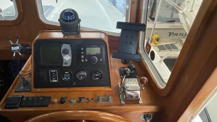
Helm has plenty of room for at least a 12-inch display, perhaps 16-inch.

This boat will go relatively fast, certainly planing speeds. Bigger is certainly better if you want a usable display when running at any speed. 7-inch might as well be a wrist-watch display. Can I justify the enormous leap in cost between small and large? Nope - it's a stupid leap. But I just don't think anything under 12-inches will be usable at speed. Question should be is 16-inch worth the extra money.

Here's the likely candidate for Eastern Boats

https://easternboats.com/boats/eastern-248-explorer/

Peter

View attachment 140821

View attachment 140822


I dunno. I have a 7" display on my flats boat that I can read just fine and it runs 45 knots. I had a 5" for a long time prior to my last upgrade, I used it for most of the 13 years I spent using the boat almost daily as a fishing guide.
 
I dunno. I have a 7" display on my flats boat that I can read just fine and it runs 45 knots. I had a 5" for a long time prior to my last upgrade, I used it for most of the 13 years I spent using the boat almost daily as a fishing guide.

Yep...everyone has their satisfactions, limitations, preferences, needs, likes, etc...etc....

Some people need detailed and large displayed info just before they run aground, hit something or blow though a restricted area....seen it plenty of times.

I get tired of hearing people tell others what they need... it's one thing to describe what THEY need, but others can g=have a completely different need/want......
 
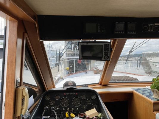
I have two 12 inch MFD. One is devoted to the radar and the other charts and AIS.
This is my last boat so I realize, the older I get, my eyes are older too.
 
I like Dan's idea. MFDs are wonderful but I hate having a single point of failure. The answer.... have 2 MFDs!
 
Agree everyone’s needs are different just like “different folks different boats”. Regardless of your choices would suggest if cruising.
One form of nav not connected to your boat’s electrical system . For many folks that’s a tablet with integral gps. Many use that plugged in to prevent battery issues in a shaded spot in the lower helm. Many place it inside a waterproof cover to prevent damage from a spilled drink or a drop.
At least 2 different chart sources you can easily switch your attention from back and forth. Can be done with a tablet and MFD but there’s other choices. We have two micro SDs in the chart plotter and a third program in the IPads but again there’s other ways to do it.
The biggest thing is to avoid screen hypnosis. To believe the screen first rather than direct physical input. Think one should be skeptical of any program or screen dependent upon a fixed program. I believe my depth, sonar, radar, eyes, ears and even smell before any screen showing a chart. Often you can see skinny water. Change in color. How the waves break. Evidence of change of how the currents flow. Often direct eyesight observations have been different than the chart. Even if charts are up to date they can be misleading. Coming from offshore you can smell land. Coastal you can smell mudflats. Think about the difference between your depth reading and what the chart says. You should be able to explain the difference.
“You can’t always get what you want. But you can get what you need” has truth. Spent some months in the BVIs. Often didn’t turn on the electronics at all. Could see traffic so no need for radar or AIS. Knew the local waters well enough no need for charts. Anchor and mooring fields quite obvious and deep water between. Nav was line of sight. The waters near my home change with every storm. Even after a strong rainfall. Although I’ve plyed those waters for decades everything goes on for every trip. But charts are a AID to navigation. Just an aid.
 
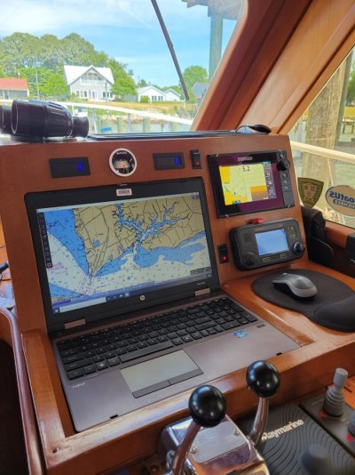
I have a $200 solid state hard drive 16" laptop built into my helm. I also have a $1200 7" Simrad chartplotter, The plotter runs Navionics and the laptop runs OpenCPN - which is free and very powerful.
 

Attachments

  • Helm tachs.jpg
    Helm tachs.jpg
    143.4 KB · Views: 26
So you wanna buy MFD. Without hesitation, I would recommend a 12 inch.
If you split the screen, put radar and AIS on one side and charts on the other, that’s about right. Now if you want to display your depth sounder/fish finder on screen, things are getting a bit cramped.
You still need a rudder indicator, and the rest of the ship’s monitoring, now things are totally cramped to the point of cant read a thing.
Unless you have other means of display, even a 12inch is too small. IF you intend to do more than radar, AIS and charts on the other, give some serious thought to two 12 inch displays.
Those are my thoughts and suggestions.
Find things you want to see a a glance are best served on small dedicated displays . Things like rudder angle or depth. Don't like to touch anything but steering, throttle and thrusters while docking. Don’t think you need to waste MFD space on them. Most of the small displays allow you to switch input. So while docking its rare to need depth beyond as an overlay on the MFD so one small display can serve both and save a boat buck. I don’t like garmin for many reasons but the new to us boat came with RM and little 4” displays. Although I went with Simrad I saved two of the RM little displays for the above purpose and always have rudder angle and depth. Have the AP on yet another one designed for that purpose from Simrad although left the RM drive unit. Many ways to skin the cat but docking want to pay attention and don’t want to fiddle with screens.
 
Last edited:
Laptops are in the same price category as MFDs and I would never consider buying a used laptop due to the pace of technology evolution. Does the same apply to buying used MFDs?
 
Laptops are in the same price category as MFDs and I would never consider buying a used laptop due to the pace of technology evolution. Does the same apply to buying used MFDs?

It doesnt take much of a laptop to run OpenCPN. Any old laptop can do it inless its a Tandy be OK.....even then it may. A $200 refurbished would be fine...heck...I have one in the closet ready to be destroyed that runs it fine.

Newer laptops have some pretty bright screens and at over 12" are WAYYYY less than a comprable MFD.

Now a whole suite of modern boating electronics can either integrate a laptop to cut costs or not...just depends on what you like and the budget.
 

Latest posts

Back
Top Bottom