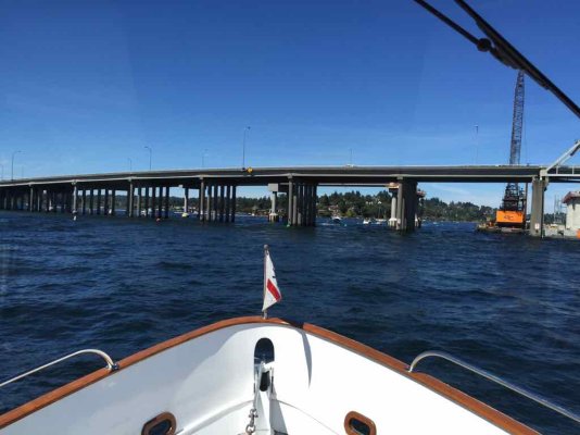
As provided in the "Local Notice to Mariners" The West Span is to be used unless you have an air draft of over 43'. If you have a 43' or greater air draft you are to contact the M/V Eagle on channel 16 for further instructions. This notice has been published and in effect since June and will run through Sept. It is always a good idea to review the USCG Local Notices prior to getting underway especially during a sanctioned event on any waterway.
And that would be a grave mistake. As I mentioned - the "West Span" is visible to the right edge of my photo and is completely obstructed by an immense floating structure for the new 520 bridge on the other side. We went through this area on our tender last week going to Westward for Happy Hour and I noted that the span lights are still in place! Not sure if they are lit though.
And I think that a radio call to the Eagle - if answered - would also yield a confusing answer.
Attached is a
diagram on the WSDOT page that shows what was in my photo.
Note the giant orange crane (not on the diagram) obstructing the Eastern half of the first...opening? passage? Not even sure what to call it...West of the "Current navigation channel (to be blocked)" on the diagram. So that one is out.
Moving West to the next opening between pilings...there is a green ball buoy clearly visible in the middle of this area with nothing around it. I believe that this is supposed to be the buoy marking the Southern piling of the Northern 520 (in fact, how would you clearly distinguish between these two parallel bridges? They are both 520!) but there is a very wide distance between that buoy and pier (visible in the center of the frame just to the left of the piling of the Southern bridge). So there's a passage with nothing occluding it with a green buoy in the middle - that might be a good choice.
Except it would mean passing the green buoy right above my burgee to port. So you shift one more passage West and head straight for another set of piles for the Northern bridge, with a dogleg right turn under the Southern bridge.
The diagram really helps, but - as everyone else has posted - virtually nobody is paying any attention to these navigation markers.
We eventually settled on the "New temporary navigation channel" as we got closer and the situation resolved itself, but just imagine coming up on this at night!
I'll also note that this is probably the North end of the "Fast Lane" that the
man who got convicted last week of "Homicide by Watercraft" was talking about.


