JDCAVE
Guru
- Joined
- Apr 3, 2011
- Messages
- 2,916
- Location
- Canada
- Vessel Name
- Phoenix Hunter
- Vessel Make
- Kadey Krogen 42 (1985)
How accurate was the Dalton Computer in air navigation in WWII? Well it turns out it was incredibly accurate. Certainly it wasn't the "weak link" in air navigation.
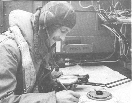
I have attached an image of the Dalton Computer demonstrated in use by an RAF Navigator.
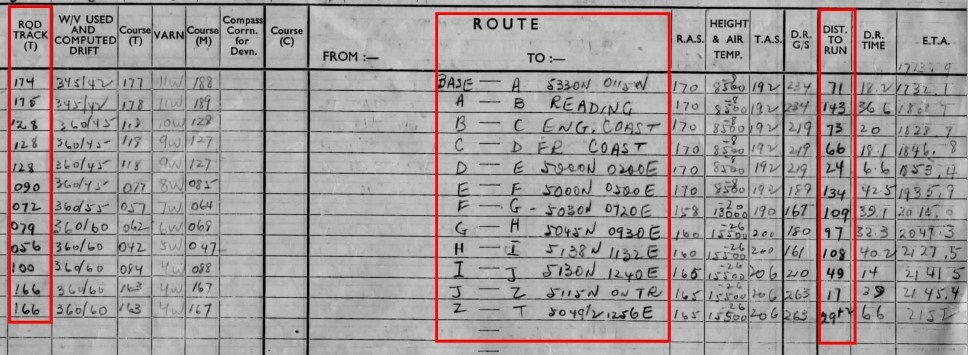
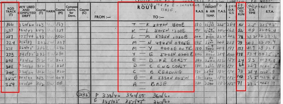
The two pages of the "Flight Plan" in the Navigation Log prepared by my father's navigator for the operation to Chemnitz, 5/6-March-1945 are shown below with the key sections emphasized with red boxes. Note that the "Lats and Longs are in Degrees and Minutes with 5450 being 54 degrees 50 minutes. There is one for route to the target and a separate page for the return route. These are attached below.
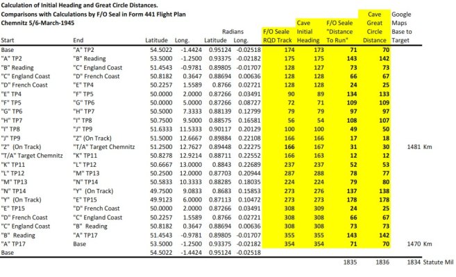
I used a spreadsheet to calculate the "Initial Heading" and Great Circle Distances, sourcing the calculations on the web (see Chris Veness, Calculate distance, bearing and more between Latitude/Longitude points.
https://www.movable-type.co.uk/scripts/latlong.html.)
Latitudes and Longitudes are transformed to Radians.
Below are the comparable calculations for my father's navigator and my own, 79 years later. Note that the "Lats" and "Longs" for some of the features such as crossing the coasts of England and France as well as some "on route" points were read off the Google map I used for the route.
The results are almost too incredible to believe. the heading are typically 0-1 degrees in difference and no more than 3 degrees. The distances are within a mile or two and there is virtually no difference in the total distance for the trip. Note that all distances are in "Statute Miles". Bomber Command was transitioning to "knots" and "Nautical Miles" in air navigation late in the war, however, some squadrons had still not received "Air Speed Indicators" with the scale in "knots" and therefore the navigation was calculated in Statute Miles.
All I can say is "Respect!" for the quality of the work that was done by these navigators!
Jim
I have attached an image of the Dalton Computer demonstrated in use by an RAF Navigator.
The two pages of the "Flight Plan" in the Navigation Log prepared by my father's navigator for the operation to Chemnitz, 5/6-March-1945 are shown below with the key sections emphasized with red boxes. Note that the "Lats and Longs are in Degrees and Minutes with 5450 being 54 degrees 50 minutes. There is one for route to the target and a separate page for the return route. These are attached below.
I used a spreadsheet to calculate the "Initial Heading" and Great Circle Distances, sourcing the calculations on the web (see Chris Veness, Calculate distance, bearing and more between Latitude/Longitude points.
https://www.movable-type.co.uk/scripts/latlong.html.)
Latitudes and Longitudes are transformed to Radians.
Below are the comparable calculations for my father's navigator and my own, 79 years later. Note that the "Lats" and "Longs" for some of the features such as crossing the coasts of England and France as well as some "on route" points were read off the Google map I used for the route.
The results are almost too incredible to believe. the heading are typically 0-1 degrees in difference and no more than 3 degrees. The distances are within a mile or two and there is virtually no difference in the total distance for the trip. Note that all distances are in "Statute Miles". Bomber Command was transitioning to "knots" and "Nautical Miles" in air navigation late in the war, however, some squadrons had still not received "Air Speed Indicators" with the scale in "knots" and therefore the navigation was calculated in Statute Miles.
All I can say is "Respect!" for the quality of the work that was done by these navigators!
Jim
Attachments
Last edited: