Dropped your navigation device lately?

The friendliest place on the web for anyone who enjoys boating.
If you have answers, please help by responding to the unanswered posts.

rgano

Guru
Joined
Oct 8, 2007
Messages
5,198
Location
Panama City area
Vessel Name
FROLIC
Vessel Make
Mainship 30 Pilot II since 2015. GB-42 1986-2015. Former Unlimited Tonnage Master
It's a given now that some of us depend on hand-help electronics to the point that they are the primary nav device aboard be it a dink or a fine yacht.

I often wonder how many of these devices are suffering untimely failures from the ordinary vulnerabilities inherent in such things like being dropped and running out of battery power?

I had my very first GPS, a Magellan 310, for years. It was pretty basic. Nothing but lat lons and a go to function. I bought it in 1995. It got dropped a couple of dozen times, and never quit working until around 2008, when it fell off the console, and then my eight year old daughter stepped right on it and cracked the screen. :facepalm:

It still worked for about another month before it finally quit.
 
I'm guilty I use a 10" I pad and iPhone for backup I have newer electronics but don't pay for the map updates I could easily get to and from most places I go without anything .except for Hatteras and Ocracoke they would be tough .
 
I'm guilty I use a 10" I pad and iPhone for backup I have newer electronics but don't pay for the map updates I could easily get to and from most places I go without anything .except for Hatteras and Ocracoke they would be tough .

Unless the chart updates are free, I would not bother. Charts seldom actually change and with a good depth sounder, you will be safe, IMO

Of course, for over 100 years Bermuda was mis-located on purpose because the pirates didn't want the 'law' to find their holdout/stronghold.
That has since been corrected. :D
 
We have 4 iPads onboard all running Navionics and AquaMaps, we also have 3 iPhones, also running both navigation apps. No problem yet with device failure. BTW, we drop them all the time!
 
Armor for the phone. Careful with the iPad.

Dirt world cables and connectors are where I have had problems.
Need marinized versions of that stuff for the flybridge.
 
We have 4 iPads onboard all running Navionics and AquaMaps, we also have 3 iPhones, also running both navigation apps. No problem yet with device failure. BTW, we drop them all the time!


I have an older iPad I’ve used for back up (or sometimes primary) navigation for years, but it has an older OS that won’t update and won’t let it download the newest apps.

I’m thinking of updating to a new one, but don’t know which one. It needs to have the cell phone connection so it can get data on the water, right? My current iPad has cell connection.


Even if you don't plan to use the cell connection for data (some apps need it, some don't need constant connectivity), it's worth having (even if you never activate it). The iPads with cell data have real GPS built in, the wifi-only ones don't.
 
Even if you don't plan to use the cell connection for data (some apps need it, some don't need constant connectivity), it's worth having (even if you never activate it). The iPads with cell data have real GPS built in, the wifi-only ones don't.


Ahh I didn’t realize the cell connection made a difference with GPS. That seems important.
 
Ahh I didn’t realize the cell connection made a difference with GPS. That seems important.


At least in the case of the iPads, it's the cellular chip that has the GPS receiver in it. The GPS function doesn't rely on an active cellular connection though. Just needs the hardware to exist.
 
I use phone and tablet for convenience but not primary nav. I have LOTs of GPS / plotter redundancy. I'm not an Apple or iAnything user.

Primary is a Dell XPS running Windows 10. Coastal explorer and OpenCPN installed. Backup for that is a Dell 5000 with OpenCPN. That laptop is for general use but ready to go in an instant. GPS sources for both are a Vesper AIS broadcasting data via WiFi or a Rose Point GPS puc or a Garmin handheld GPS via USB.

Hardware is A Garmin with it's own GPS and depth sounder on the fly bridge.

The Android phone is loaded with OpenCPN and Navionics. The phone has built in GPS. The ancient Android tablet is loaded with OpenCPN and also has built in GPS. Both androids can be set to receive the Vesper WiFi data so I have AIS on them as well.

I pack a Garmin inReach which can also give GPS lat / long. But I would have to manually plot that data.

Also a stand alone Furuno radar and Furuno sounder.

And I still carry some paper charts...
 
Dropped a sextant once at the academy, they weren't impressed. I've never dropped mine of course and all my electrical gadgets are attached to something so no risk of dropping.
 
There are “shock proof” cases for most portable devices. Won’t solve the over the side problem though.

The good navigation apps are so cheap, it’s hard to believe.
 
Even if you don't plan to use the cell connection for data (some apps need it, some don't need constant connectivity), it's worth having (even if you never activate it). The iPads with cell data have real GPS built in, the wifi-only ones don't.

The built-in gps is not as accurate as the standalone units. Just buy the cheapest iPad you can find and pair it with a Bluetooth GPS or WiFi GPS. I have a Vesper AIS that is WiFi enabled and I connect my iPads to it or to the Dual Bluetooth GPS.
 
I still have a Garmin Map 176C from 2001 that I take along in the dinghy. The tide chart is out of date though and it doesn't cover Canada.
 
My backup is very durable. It is far from new but I love it and often use it as my primary navigation tool.

I can write on it, it is portable, lightweight, easy to understand and the best part is that it is foldable. Yep, its paper.

pete
 
The built-in gps is not as accurate as the standalone units. Just buy the cheapest iPad you can find and pair it with a Bluetooth GPS or WiFi GPS. I have a Vesper AIS that is WiFi enabled and I connect my iPads to it or to the Dual Bluetooth GPS.
I know that used to be true, but I'm not sure it still is. I've cross checked my Android devices to dedicated marine hardware many times. I'm not seeing any significant difference.

It may depend on where you boat. Years ago I read an indepth article on the accuracy of Apple's built in GPS receiver's position accuracy compared to high end land survey gear. Written by a surveyor.

The author's conclusion was overall the Apple GPS was very good, approaching the accuracy of dedicated survey gear. With two very important differences.
1 - The Apple GPS priortized speed to fix vs accuracy.
2 - To achieve the best speed to fix the Apple GPS would use cell tower triangulation when necessary.

What this could mean to the boater is that if your phone or tablet GPS is having difficulty getting fast high quality GPS signals it MAY drop to cell tower triangulation.

Why I say it MAY matter where you boat has to do with proximity to cell towers and obstructions of GPS signals.

The article is many years old so things have changed. At the time I read it there was a frequently noticeable difference between phone/tablet positioning and dedicated marine hardware positioning. I have not seen that difference in years.

The problem of course is your phone/tablet won't tell you when it's using cell towers vs GPS signals.

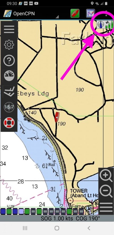
OpenCPN on Android has a GPS signal strength indicator. I would be good to know if this is truly GPS signal or just position data from either GPS or cell tower triangulation.

For those reasons I generally trust the phone/tablet running OpenCPN. But if I need truly accurate position data I used dedicated marine devices.
 

Attachments

  • OpenCPN GPS signal.jpg
    OpenCPN GPS signal.jpg
    109.3 KB · Views: 36
I often wonder how many of these devices are suffering untimely failures from the ordinary vulnerabilities inherent in such things like being dropped and running out of battery power?

Hi Rich,

After dropping two (2) "smart" Apple IPhones, at something like $700-$1000 a pop, in the drink, I have since refused to bring one aboard until they become smart enough to swim. And yeah, yeah I know they have waterproof cases available. Not much help when they reside on the seafloor. Ditto tethers, which manage to drive me nuts when I chose to wear pocketless shirts. Ditto floatable cases. Ever tried to put one of THOSE things in your pocket!

Watching several yacht brokers being reduced to tears ("aaarrrrrrggghhhh, #$%^&*-my whole LIFE is on that phone...!!!!) when their smartphones go swimming makes me a non-believer.

Sigh.

Regards,

Pete
 
I know that used to be true, but I'm not sure it still is. I've cross checked my Android devices to dedicated marine hardware many times. I'm not seeing any significant difference.

It may depend on where you boat. Years ago I read an indepth article on the accuracy of Apple's built in GPS receiver's position accuracy compared to high end land survey gear. Written by a surveyor.

The author's conclusion was overall the Apple GPS was very good, approaching the accuracy of dedicated survey gear. With two very important differences.
1 - The Apple GPS priortized speed to fix vs accuracy.
2 - To achieve the best speed to fix the Apple GPS would use cell tower triangulation when necessary.

What this could mean to the boater is that if your phone or tablet GPS is having difficulty getting fast high quality GPS signals it MAY drop to cell tower triangulation.

Why I say it MAY matter where you boat has to do with proximity to cell towers and obstructions of GPS signals.

The article is many years old so things have changed. At the time I read it there was a frequently noticeable difference between phone/tablet positioning and dedicated marine hardware positioning. I have not seen that difference in years.

The problem of course is your phone/tablet won't tell you when it's using cell towers vs GPS signals.

OpenCPN on Android has a GPS signal strength indicator. I would be good to know if this is truly GPS signal or just position data from either GPS or cell tower triangulation.

For those reasons I generally trust the phone/tablet running OpenCPN. But if I need truly accurate position data I used dedicated marine devices.

All I know is that with the built-on GPS, my nav programs will show me 50’ to 100’ feet away from whatever slip or dock we are moored at. Connect to the external GPS sources and it shows exactly where I am down to the correct side of the finger pier. That is enough to convince me!

Also the iPads will match the Furuno chart plotter when using the external GPS, but not when using the internal GPS. It’s only a few dozen feet, but when following a narrow channel that all it takes to run aground.
 
Last edited:
I've had good experience with a GPS puck talking to the iPad.
I've walked around the boat with the puck, knows where I am, amazing.

Always run the chart plotter too and cross check. And dead reckon.
 
"Watching several yacht brokers being reduced to tears ("aaarrrrrrggghhhh, #$%^&*-my whole LIFE is on that phone...!!!!) when their smartphones go swimming makes me a non-believer."


I back-up my android monthly for just that reason. Lost one to a feeder band down-pour while preparing the boat before hurricane Mitch a few years ago.
Also delivered a new SeaRay 51, with no plotter aboard, to Tampa from Canaveral using Navionics on my phone. Took me right up the bay, no problems.
 
Guys guys guys, eat your heart out. I have a hand held Magellan Map 330M GPS. SMILE It was THE only way to go if you wanted a hand held.
Guided me from Long Island all the way down to Miami, inside and outside.
I paid BIG bucks for it and today, you can buy one for $22 on eBay.
 
Last edited:
iPad Pro has Internal gps issues... apple is aware of the issue

If you are looking for a cheap backup, there is a Galaxy phone that runs AquaMap Master for about $100. Can’t remember the model #.

I’m sure that in some areas paper is fine, but using the ICW, the sand bars move around, mud silts in channels and buoys get moved too often. You really need the chart update service that comes as part of the program.
 
I have 2 older Dell laptops running Coastal Explorer. The laptops were around $225 on ebay but you can get cheaper. I ran the older one yesterday, its maybe 6 yrs old, running Windows XP, maybe older cant remember. It works just fine. The newer one has a larger screen which I like better. They never fail to get me where I want to go.
 
What are the odds that I loose my helm instruments, an I-pad, A cell phone and lastly the computer at the same time!
 
Ahh I didn’t realize the cell connection made a difference with GPS. That seems important.

u don't need a cell connection & no need to pay for a data plan but you do need the iPad with cell connectivity possible (not WiFi only). The GPS is built into the cell/data access chip on iPhones/iPads, but doesn't need a cell plan/signal to work normally. Most Android tablets have GPS built in regardless of cell access chip but check each model, there may be a few dinosaurs out there.
 
Unless the chart updates are free, I would not bother. Charts seldom actually change and with a good depth sounder, you will be safe, IMO

Of course, for over 100 years Bermuda was mis-located on purpose because the pirates didn't want the 'law' to find their holdout/stronghold.
That has since been corrected. :D

interesting approach - given how inexpensive the AICW USACE data updates etc. are on Aquamaps master subscription ($10). Btw will also interface with your AIS for max. GPS accuracy. Many use it for primary nav or backup to Navionics on a separate device along with Bobs 423 tracks. Aquamaps also uses Explorer charts in the Bahamas.
 
No batteries , only dropping overboard would harm my paper charts and pencil.


The hand held GPS units get out dated before mere dropping harms them.
 
Last edited:
Guys guys guys, eat your heart out. I have a hand held Magellan Map 330M GPS. SMILE It was THE only way to go if you wanted a hand held.
Guided me from Long Island all the way down to Miami, inside and outside.
I paid BIG bucks for it and today, you can buy one for $22 on eBay.

I think I paid around $150 for my Magellen 310 in 1995. I see one on Ebay today for $18.99. :D
 
Back
Top Bottom