Accuracy of autopilot

The friendliest place on the web for anyone who enjoys boating.
If you have answers, please help by responding to the unanswered posts.

83GB

Veteran Member
Joined
Dec 28, 2014
Messages
48
Location
USA
Vessel Name
Seminole
Vessel Make
42 Grand Banks Classic
I have a GB 42 Classic with a SITEX SP70 autopilot with a NMEA 0183 connection to my Garmin 1042xsv chart plotter. When I start a route on the 1042xsv and "tell" the SITEX to "navigate" (follow the route), the autopilot kinda follows the route. Even in calm waters with no wind or current, it steers the correct compass heading and makes each turn in the route but most times, it is 50 feet or so on either side of the route line... sometimes, it is right on the route line.

What kind of route following accuracy are others seeing? Does your vessel stay within a few feet of the route line? Also, I have posted to a few face book groups and ALL comments come back with suggestions on how to improve accuracy but NO ONE tells me how their autopilot performs.... I want to know if what I am getting is as good as marine autopilots can do...
 
I don’t see any departure in the course line and route in most conditions. In the Raymarine EVO system you can pick different levels of performance. I run on the lowest level most of the time to minimize the amount of cycling of the pump.

Tom
 
Interesting question. Does the navigate function of an autopilot following a series of waypoints steer a heading between waypoints, or does it steer to the waypoint the way GPS navigation software does on roads and highways?
 
that sounds ok to me. to make it exactly on the line could require over string.
 
Your autopilot first and foremost follows its own compass heading when you are the "auto" mode. It doesn't matter if the pilots compass is off from the actual heading. All it knows is to stay on the same heading as when you pressed auto.
When you want the pilot to steer you to a waypoint, it then has 2 headings it needs to follow; the pilots compass magnetic heading and now the cog heading to the waypoint on the gps. It's really helps that you do the setup and calibration for the pilot compass and that it is close to the gps's COG heading on all quadrants if you want the pilot to do a good job of following a line to a waypoint. Otherwise, the pilot is always trying to make corrections to the waypoint from the cog data that the gps is sending and at the same time trying to reconcile the heading that it's own compass it telling it to follow.
 
The chartplotter “knows” the path between waypoints. It also “knows” the compass heading to get from the starting waypoint to the next waypoint. Those are two different means to an end.

When in Auto mode, my Simrad AP16 holds (or tries to hold) the compass heading displayed. When in Nav mode, it controls the rudder to stay on the path between waypoints.

Or does it? Maybe the autopilot simply determines the compass heading from the starting waypoint to the destination waypoint and passes that heading to the autopilot to follow. Accuracy of arrival at the destination waypoint would then depend on how close the autopilot rate compass matches the compass information the chartplotter gets from GPS. Anyone know which it is?
 
Interesting question. Does the navigate function of an autopilot following a series of waypoints steer a heading between waypoints, or does it steer to the waypoint the way GPS navigation software does on roads and highways?
In the NMEA 0183 APB and XTE sentences, there is a cross track error.... measured in distance.... that is the distance one is off the line.... In APB, there is also a parameter that says to steer right or left to get back on the line... Not sure why my SITEX SP 70 does not simply turn back to the line when it is off... maybe it does but it is SO slow....
 
So at least your SITEX SP70 autopilot adjusts the rudder to stay on the course between waypoints rather than hold a compass course between the two. Do they all work that way?
 
So at least your SITEX SP70 autopilot adjusts the rudder to stay on the course between waypoints rather than hold a compass course between the two. Do they all work that way?
Basically, yes. The “Auto” (autopilot) function steers the compass course you selected, whereas the “Nav” (navigation) function sets a straight line route between two known points and steers towards the target by monitoring (& correcting) any cross track error due to wind, waves & current.

There are several variables that determine the response of your AP. Accurate GPS & heading data are the most critical , followed by the response time of your mfd and steering pump. That’s why others have advised you to optimize settings.

For instance, I found a big improvement when I added a 2019 Vesper AIS to my 2016 Simrad network & 2004 vintage AP25/ GOS antenna.The AIS transmitter mandates its own, dedicate GPS antenna which was apparently more accurate than the legacy version. That said, whenever I activate Nav, the boat still turns to port (off track) initially. Always gets back on the line, but can be exciting in a narrow channel. Do go through all the dock and sea trial calibrations for your AP, they can help tremendously
Slight correction..... On the SITEX SP70 there are two modes.... P or N.... P being Pilot which steers a compass heading and N is Navigate a route provided by an external source. The SP70 has it's own fluxgate compass for heading (which one must calibrate by taking the boat out and spinning circles).

In my case, I do not have hydraulic steering; mine is cable drive and I use a very old, but solid and reliable, NECO autopilot drive motor. A local marine electronic shop integrated everything. He said the motor was very robust and he was able to use the relays inside the SP70 control unit to directly drive the motor (and clutch)...

I had thought a more accurate heading sensor might improve my setup... So I got a Garmin GPS 24XD gps with built-in heading sensor... That made things worse I believe. Now the 1042xsv would send navigation info (nmea APB and XTE sentences) to the SITEX based upon its heading info. The SITEX had its own fluxgate compass/heading sensor which may or may not agree with what it was getting from the 1042xsv/GPS 24XD... and I think that confused the SITEX...

So I changed the heading source in the 1042xsv to take in (via nmea) the heading data from the SITEX and ignore heading from the 24XD (but the 1042xsv still uses the 24XD for GPS position which it can use to determine cross track error). This made it better but the boat will not steer on the line or "run over" way points....

At this point, I am investigating sending the fluxgate back to SITEX for testing.....
 
Does "heading sensor" mean GPS compass? Whether your 1042XSV gets its input from the 24XD or from the fluxgate compass on your old SP70 shouldn't matter if the SP70 is set to Navigation mode, right? What difference does it make what the compass is pointing to if the SP70 is just trying to keep the boat on the magenta line?
 
I think this has mostly been covered, but here goes, with an attempt to answer the few residual questions.

In Nav mode, aka Track mode, the pilot follows the track line that the chart plotter creates between two points. But the pilot is largely running blind, and the plotter is telling it what to do. It tells the pilot to heading to the waypoint, and it tells it how far off the track line (cross track error, or XTE) the boat currently is. Based on this the pilot steers trying to keep the XTE as close to zero as practical.

The better the compass and the better the GPS, the better the pilot will steer. If you GPS is varying then the pilot can't steer any better than that.

In calm water my pilot runs 0-6' off the track line. But as mentioned by others, the pilots I have dealt with have settings to control how aggressively you want it to try to stay on the line. 50' off is a lot in calm water. I'd start by trying to find the setting for how closely teh pilot will track the line. It's a pilot setting, not a plotter setting.
 
The term "GPS compass" can be confusing (IMHO)... A GPS by definition, gives one LAT/LON information only. The chart plotter can take GPS position LAT/LON at one point in time; Then it can take the position LAT/LON at another future time and calculate a "heading".... but this can be wrong... The heading should be the direction the boat is actually pointing. For example, if one is in a strong cross current (like the gulf stream crossing from Florida to the Bahamas), the boat will "crab" to stay on the route line. A fluxgate compass, shows the instantaneous direction the boat points. A calculated "GPS compass" cannot tell that the boat is crabbing... that said, the GPS 24XD has a built-in heading sensor (I am guessing fluxgate) and a highly accurate GPS..

I would have thought that if the SP70 autopilot were truly dumb in the Navigate mode, it would take the data coming via nmea from the chart plotter and follow it. I think the SP70 uses some form of algorithm using its own fluxgate with the data it is getting from the 1042xsv, and determines how to steer.

I can see the nmea APB sentence the 1042xsv is sending to the SP70.. That sentence will say you are off the magenta line by X nautical miles and the same sentence says steer right to get back on course.... the the SP70 does not do it... at least not quickly. If it were truly dumb, it would turn 90 degrees and head to the magenta line... but it does not... it just hangs off the side of the magenta line until a turn is sent... then the boat turns..
 
I think there may be some confusion between the function of the compass versus GPS in sending data to the autopilot. The GPS COG is not as accurate as a compass in the heading data needed by an autopilot. You can run an autopilot with COG but at slow speeds the autopilot will wander as the COG heading changes based on the calculations. The GPS determines COG by movement. A compass doesn’t worry about movement. While underway at 7.5 kts my autopilot heading is 316, my compas heading is 316, but my COG is constantly variable between 317 and 320 and we are in calm conditions. So using using COG would result in the autopilot moving the rudder frequently when in fact the heading hasn’t changed. A satellite compass is a GPS system of high precision, not something you will find in the GPS in a typical MFD, that is generally more accurate than most compasses and more expensive.

Tom
 
I have an old Benmar 220 that back in the day connected with loran was probably state of the art. Now, no loran connected, just a compass course with an old worn out compass. On good days it holds a compass course. Get some wind/waves and it wanders.
As mentioned a compass course tries to point the boat along the magnetic line, so it meanders trying hard to hold a course.
 
I had the same autopilot and an older Garmin plotter. + or - 50 feet is probably what mine did. However most of the time i let it steer to a compass heading because it didnt snake wake much that way.
We travelled several thousands of miles with that setup.
 
Might want to read the article about autopilots on Attainable Adventures. As time has gone by there’s a huge difference in autopilot performance and a huge difference between price points.
I’ve been on boats with the current generation of the high tech versions (a NKE) it predicted oncoming waves and wind gusts and had a learning function. It was a better helmsman than any human on the boat even in significant weather. But you’re looking at tens and tens of thousands of dollars for it and its ancillaries. My take away was there’s basically three levels of APs. Old school, current low price point and expensive high tech with predictive capabilities. Even at current low tech you’re offered several ways for the AP to work. Usually some form of heading, some form of no drift and some form of navigate. There’s a small trade off. The more you steer the slower you go. Steering creates drag. But the more you wander the more you lose velocity made good. Currently have the current version of the simrad. Overall it does best in no drift. In the past varied sensitivity depending on seastate. Now no longer do that. Rebuilding a ram isn’t a huge undertaking. Electric draw isn’t a concern on a powerboat like it is on a sailboat. I’m now coastal so want it to be as accurate as possible. The AP does 95% plus of the steering. I no longer use the wheel except docking. Love the freedom that gives.
 
To add to what Hippocampus said, there's also the issue of fatigue. Even if you can steer better than the autopilot, you probably can't do it for hours on end, especially in rough conditions. Once you start to get tired, a decent autopilot will almost always outperform a human helmsman.
 
The term "GPS compass" can be confusing (IMHO)... A GPS by definition, gives one LAT/LON information only. The chart plotter can take GPS position LAT/LON at one point in time; Then it can take the position LAT/LON at another future time and calculate a "heading".... but this can be wrong... The heading should be the direction the boat is actually pointing. For example, if one is in a strong cross current (like the gulf stream crossing from Florida to the Bahamas), the boat will "crab" to stay on the route line. A fluxgate compass, shows the instantaneous direction the boat points. A calculated "GPS compass" cannot tell that the boat is crabbing... that said, the GPS 24XD has a built-in heading sensor (I am guessing fluxgate) and a highly accurate GPS..

I would have thought that if the SP70 autopilot were truly dumb in the Navigate mode, it would take the data coming via nmea from the chart plotter and follow it. I think the SP70 uses some form of algorithm using its own fluxgate with the data it is getting from the 1042xsv, and determines how to steer.

I can see the nmea APB sentence the 1042xsv is sending to the SP70.. That sentence will say you are off the magenta line by X nautical miles and the same sentence says steer right to get back on course.... the the SP70 does not do it... at least not quickly. If it were truly dumb, it would turn 90 degrees and head to the magenta line... but it does not... it just hangs off the side of the magenta line until a turn is sent... then the boat turns..
The Sitex manual covers how to adjust the autopilot. I would suggest starting with that to ensure the basic steering control is working as best it can. Pay particular attention to the Fast and Slow settings. Depending on boat speed, it takes more or less rudder to control the boat. This is particularly true of planing boats.

You hit on some important points above, but let me restate them in terms use by nav electronics.

Heading is the direction the bow of the boat is pointing. This isn't necessarily the direction that the boat is actually moving once you factor in current, wind, etc. Heading comes from an electronci compass of some sort, typically a Flexgate, Rate Compass, or Satellite Compass.

Course, aka Course over Ground, aka COG is how the boat is actually moving. As you surmised this is calculated based on successive position reports. One difference is that it's done by the GPS device, not the plotter. A GPS will report position, COG (direction of movement) and Speed over Ground (SOG).

We can only guess what the actual algorithms are in the pilot, but to me it makes sense that it steers a heading to match the Bearing to Waypoint heading that it's given from the plotter, then adjusts that heading as needed to correct for cross track error. That will also correct for set, drift, and any other external influences. Although I didn't see it in my quick scan of the Sitex manual, newer pilots have a setting called "response" or something like that to control how aggressively the pilot tries to correct cross track errors. Yours is very lax about that. But I can't say of that's because your fundamental steering settings aren't optimal, if there is a "response" setting that I'm not seeing, or if 50' of XTE is normal for the Sitex. For any pilot made in the last 15 years I'd say 50' is a very large XTE in calm water, and likely to trigger an alarm.

Getting back to Heading vs Course, the convention seems to be that an AP in Auto mode steers to a heading. That said, some have options like "no drift" where the pilot will steer a Course rather than a heading. But I have been told that in some implementations of "no drift" the pilot creates it's own trackline from current position to the waypoint, and essentially operates in Nav mode using it's internally computed track line rather than a trackline computed by the plotter.
 
I have a Raymarine AP that uses NMEA0183, a Garmin 1242XSV, and a Garmin Steadycast heading sensor. I disconnected the Raymarine heading compass and only connected the NMEA0183 TX + and - from the Garmin MFD, to the NMEA0183 RX + and - on the AP. This forces the AP to use only the heading from the Steadycast and it works great. And it only requires two wires.

Prior to that, the discrepencies between the Raymarine heading compass and the Steadycast heading sensor made my AP wander as you described when following a route.
Good point here that it's really important that all your devices are using the same heading and position data sources.
 
The autopilot on Slow Hand is a Simrad / Robertson AP20. It was my understanding that the pilot ran on the autopilot compass when in Auto mode (steering on a compass heading). When in Nav mode (steering to a waypoint or route from from a MFDs) the steering is still kept on compass heading by the autopilot compass, but course corrections are a function of the MFD.

So, first you need to make your autopilot steering rock solid in auto mode. Then secondly, if there are adjustments to the MFD, you may need to make adjustments to them.

It's important to understand that if navigating in shallow water, your autopilot compass may be effected my magnetic anomalies in the ground. So unless you're using a satellite GPS compass, there's very little you are going to do to compensate for that. Most autopilots have parameters that can be adjusted in the control console to dramatically improve the tracking performance. I would start by studying the owners manual.

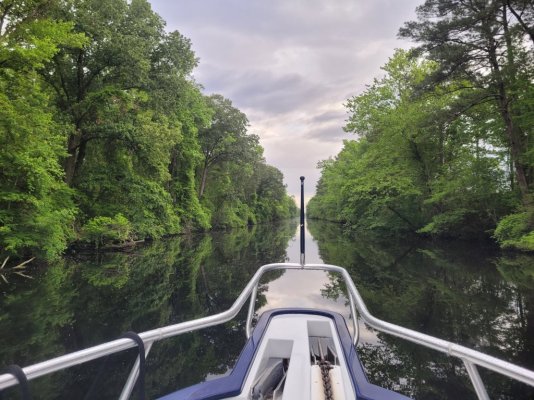
I cruised on autopilot probably 98% of the time, although mostly in Auto mode. As such, it needed to be near perfect. Below is a picture of the Dismal Swamp canal. I ran through it over 20 times on two boats, on autopilot. When your parameters are right, you only need to add or subtract a degree to stay in the center. FYI, stay focused, there are a few magnetic anomalies under the mud of the canal.

Ted
 

Attachments

  • 20230430_072917.jpg
    20230430_072917.jpg
    214.1 KB · Views: 36
Good point here that it's really important that all your devices are using the same heading and position data sources.
This seems very important. If the pilot receives a course from the plotter then uses a course from its own rate compass plus adjustments from XTE sentences, then the rate compass heading must be darn close to the GPS heading. They aren't close on my current combination.
 
I hate to be pedantic here, but the terminology is important. A rate compass or other heading sensing device will report the boat's heading, i.e. where the bow of the boat is pointing. A heading sensor doesn't know what direction of speed the boat is actually moving, just where it's pointing.

A GPS reports how the boat is moving, aka its course. It doesn't know where the boat is pointing, just how it's position is changing over time, both in speed and direction.

So you can have a boat is pointing due north, but is drifting due east. The heading sensor will report north, and the GPS will report east. That's an extreme example, but it's very common for heading and course to be different by at least a little bit, and if you have a lot of cross current they can differ by 10 deg or more.

For an AP to work well, you don't need course and heading to be the same. That's good because they almost never will be. What you DON'T want are two different heading sensors used by different devices. Most APs have a heading sensor associated with them, and often times that same heading info can be used by a plotter. But there are weather instruments that also include a heading sensor, you could have a second rate compass for redundancy or for a different system, or you could have a satellite compass. All of these will be reporting a heading, but they will likely be slightly different from each other. Things get really screwy when an AP is listening to one compass, the plotter is listening to another one, and your radar is doing ARPA based on a third compass.

And the same thing can happen with multiple GPSes, something that is almost a certainty on most boats these days. VHFs, AISes, chart plotters, weather instruments often include their pwn GPS, and blab that out over the N2K network.
 
Definitions certainly matter. I understand the physics of the situations, but not the design and construction of the various compasses. My search strategy has been letting me down lately too. What is the difference in design, construction, and application between a rate compass, a flux gate compass, and a “standard” magnetic compass?
 
Definitions certainly matter. I understand the physics of the situations, but not the design and construction of the various compasses. My search strategy has been letting me down lately too. What is the difference in design, construction, and application between a rate compass, a flux gate compass, and a “standard” magnetic compass?
Good question, and I'm not sure I fully know the answer. But here's my understanding...

I *think* the difference between a fluxgate and a rate compass is that the rate compass provides both heading and rate of turn (ROT). Both are based on the same underlying technology, but a rate compass gives more info. If anyone knows otherwise, please chime in.

Historically heading sensors were gyros, and in IMO certified equipment the inputs are still commonly called "gyro" even though it's looking for a NMEA heading message. I've never heard of a gyro on a recreational boat.

A satellite compass is a pretty cool device, and is simply 2 or 3 GPS receivers arranged in a fixed relationship to each other. Then, with calculations that are way over my head, it can look at the differences in the received GPS info, and knowing the geometry of the receivers, it can tell with great precision what direction it's pointing. Plus with the three receivers, you can calculate a more accurate position and course over ground. They are fantastic devices, super accurate, provide true heading, immune to external magnetic interference, immune to stuff in drawers and closets, and immune to magnetism from heavy electrical loads like a microwave. And you get both a heading sensor and gps all in one. The down side has been that they were expensive - say $3k to $5k - but are now available for about $1000 which is less than you would pay for a quality GPS plus rate compass.

Then you mentioned a regular magnetic compass, which to me is the vintage thing on your console that is never accurate, but hopefully accurate enough to get you home if all else fails. Both those don't provide any data that can be used by nav equipment, just visually by a person.
 
My Raymarine ST6001 is very repeatable +/- 70 up to 120 ft either side of plotted course line. It does not alter course until it is >70 feet to either side. It sometimes waits for 110 ft off course. Very frustrating in canals.
 
My Raymarine ST6001 is very repeatable +/- 70 up to 120 ft either side of plotted course line. It does not alter course until it is >70 feet to either side. It sometimes waits for 110 ft off course. Very frustrating in canals.
Wow, that seems like a lot. Have you checked to see if there is a configuration setting in the pilot?
 
Yes. Funny thing is at 60 ft cross track error the display shows an arrow that it needs to turn but does nothing to correct. Then at about 90 ft it finally starts changing the course to steer to correct. I’ve sat with the installation guide on many trips across Lake Okeechobee trying different settings but there is no way in the manual to shrink the initial 60 ft.
 

Latest posts

Back
Top Bottom