AIS Transmit

The friendliest place on the web for anyone who enjoys boating.
If you have answers, please help by responding to the unanswered posts.
I have had a couple of AIS tracking sites take up to several hours to show a new position for our boat after the AIS is turned on. One of them took almost 3 days to update after we updated our vessel name and call sign on the on-board AIS/DSC, so just from my personal experience your 1/2 hour of on time may not have been enough.

I was just on a boat with AIS for the first time so took an interest in watching it closely. Boats in the distance in the general direction expected, but boats closer were no where near where displayed. So much off that I cannot see how people like it so much if that is normal display. Stationary boats in anchorage all were in displayed position. :nonono: no sale, not on wish list.
 
I have been following your quest with interest. I think once you get hooked up with the software you will find your problem. At this point you dont know if the unit was ever setup. I have a vesper but still had to enter the data and then enable broadcasting.There were no default settings. As far as marine traffic i get notified by email 5 minutes into a trip and continue to get notified at every stop so its not much delay.I believe you also need a separate dedicated gps but not sure .I only understand vesper but would think they are all somewhat the same.
 
I was just on a boat with AIS for the first time so took an interest in watching it closely. Boats in the distance in the general direction expected, but boats closer were no where near where displayed. So much off that I cannot see how people like it so much if that is normal display. Stationary boats in anchorage all were in displayed position. :nonono: no sale, not on wish list.


How close is "closer" where the boats were not shown in their actual location? And where/how were the AIS targets displayed? On the boat's chart plotter?


Class B AIS updates are every 30 seconds, so for a fast moving boat, and one closer to you, that can represent a lot of movement But AIS isn't really meant for close in maneuvering. It's for awareness of who's out there and what they are doing so you know who to pay closest attention too. Like all such things on a boat, it's just a tool that's good for some things, and not so good for others, hence the reason on why we have bags of tools rather than just one.
 
Close. Good point I should have stated distance. Remember, not all boats have AIS.
AIS on chart plotter. Very accurate in anchorage so direction was not a question.
By memory, the chart plotter was mostly at 5 nautical miles. Vessels were traveling mostly east/west. When I say in distance that would be 5 miles as they appeared on screen I would watch progress (on screen and by visual).
Close was 1/4 to 2 miles. As they entered the 2 mile range I noticed a separation of visual and screen direction.
I actually had one boat I could not find where it displayed and got others to look. Yes 30 seconds is a long time when two boats are travelling in opposite direction passing each other. That is when I noticed that a boat 90* to my track was showing about 60*.
I had one boat approach on collision course until course changes were made so that was interesting to watch.


These are all great examples and lessons about the importance of knowing what each instrument/device can and can't do. Each has it's strengths and weaknesses, and each adds unique value while at the same time overlapping with other devices.


With respect to faster moving boats, one thing I find helpful is to turn on the heading vectors for AIS targets, or at least for those of interest. That will immediately show which are moving fast and which are moving slowly. Then you'll know which targets might have moved significantly from their indicated position. This is also a situation where radar and AIS complement each other nicely since the radar will update about every 2 seconds.
 
For some class B AIS, the signal period is based on the sending boat's speed. In one case, the signal period is every 5 seconds when the vessel exceeds 25 knots. I'll never need to send that often, but it would be nice if those with fast vessels had an AIS with this feature. I have noticed that the Washington State Ferries update faster than surrounding recreational boats.

I just went through hours of research getting ready to purchase an AIS transponder. Separate antenna or antenna splitter? WiFi or NoFi? NMEA 0183 or NMEA 2000? Prices can vary by $500 for what (to my needs) are identical transponders. Made my decision and called vendors. Out of stock everywhere. Due back in stock in 2023. Not sure if the model will change by then. Ended up ordering something with completely different features.
 
In my example we are talking about two boats doing less than 10 knots each which can be said the signal is moving at 20 knots
 
Has anyone a Class A AIS on their 'pleasure boat'?
Do the benefits of the Class A justify the price?
 
The unit needs to be programmed with a cable and PC. I did mine after I received my MMSI number.
 
For some class B AIS, the signal period is based on the sending boat's speed. In one case, the signal period is every 5 seconds when the vessel exceeds 25 knots. I'll never need to send that often, but it would be nice if those with fast vessels had an AIS with this feature. I have noticed that the Washington State Ferries update faster than surrounding recreational boats.

I just went through hours of research getting ready to purchase an AIS transponder. Separate antenna or antenna splitter? WiFi or NoFi? NMEA 0183 or NMEA 2000? Prices can vary by $500 for what (to my needs) are identical transponders. Made my decision and called vendors. Out of stock everywhere. Due back in stock in 2023. Not sure if the model will change by then. Ended up ordering something with completely different features.


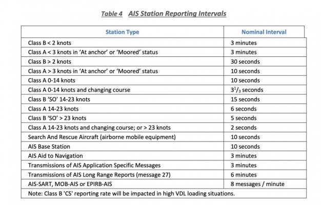
Class A and the newer Class B-SO transmit faster with faster boat speeds. But Class B is always 30 seconds for anything over 2 kts.


Attached is a summary showing the three different types and reporting intervals.
 

Attachments

  • Untitled.jpg
    Untitled.jpg
    133.2 KB · Views: 49
I have been following your quest with interest. I think once you get hooked up with the software you will find your problem. At this point you dont know if the unit was ever setup. I have a vesper but still had to enter the data and then enable broadcasting.There were no default settings. As far as marine traffic i get notified by email 5 minutes into a trip and continue to get notified at every stop so its not much delay.I believe you also need a separate dedicated gps but not sure .I only understand vesper but would think they are all somewhat the same.

OP has a Garmin 600. It has a number of status led's. One for power on, On for receive, one for transmit, and one for not ready to transmit. If transmit led is on, and it's not showing up on AIS apps, then the antenna is suspect. It could be tested with a spare VHF antenna.

If the not ready to transmit led is on, then the mmsi number is not programmed, the gps antenna has failed, or it's in silent mode. (It's not in silent mode because the OP's photo indicates the port is not connected.)

A second gps antenna can resolve the antenna question. Loose or corroded cable connections are always a suspect. ProAIS2 might help view the Garmin settings but I don't have Class B so I'm just guessing on that one.
 
Does anyone know if the Garmin AIS 600 uses ProAIS to configure it? Most AIS devices do, but I don't know if Garmin strayed on this.


If it does use ProAIS, the I would just go straight to that. It's very easy to use, and connects with a simple USB cable. It will show you exactly what's going on, and take all the guesswork out of getting this unit working.
 
I was just on a boat with AIS for the first time so took an interest in watching it closely. Boats in the distance in the general direction expected, but boats closer were no where near where displayed. So much off that I cannot see how people like it so much if that is normal display. Stationary boats in anchorage all were in displayed position. :nonono: no sale, not on wish list.

I regularly go by cargo ships at the port here, and they display precisely where they are moored, and I always get a warning "AIS target too close" when I close to within the quarter mile zone I have set.
 
Does anyone know if the Garmin AIS 600 uses ProAIS to configure it? Most AIS devices do, but I don't know if Garmin strayed on this.


If it does use ProAIS, the I would just go straight to that. It's very easy to use, and connects with a simple USB cable. It will show you exactly what's going on, and take all the guesswork out of getting this unit working.

Garmin shipped their own Windows software for configuring the 600. When I needed it a couple years ago I had to do some sleuthing to find a copy online. I probably still have a copy if anyone needs one.
 
AIS 600 Transmitted

Hi All -

Just a quick follow up on my saga. In a previous post of about three weeks ago I had told you that I finally located the Garmin AIS 600 above the Port Forward panel over the galley. It was definitely not transmitting and there were a couple of yellow lights with no TX light. So I asked my electrical guy to take a look at it and he came with his laptop and the startup sw loaded but he did not have the correct USB cord for the AIS end. So he told me that he would take it and get the correct cord at home. Two weeks later after a lot of lame contractor excuses I demanded it back and went to his house to get it. Typical contractor lies and he will not step foot on my boat again.

So, the very next day I go to the boat and hook up my portable PC with a correct cord and SW. Immediately I look and the MMSI is all zeros - the POs had never entered the MMSI into unit. I entered it and the other basic static info requested. The yellow lights went away and I now had a green "ALL OK" and blinking green REC lights. I checked the mainretraffic.com sight and no boat showed up for about an hour. Turned system off and communicated with Garmin support for a couple of days - they were knowledgeable and helpful. The AIS 600 does need a dedicated GPS receiver - which it has. I was a little confused because there is a FURURO GPS looking antenna also in the fly bridge enclosure that I always assumed was obsolete from a previous setup. But with Garmin's assist I determined my set up was correct. It is also true that the 4 GPSMAPS onboard have their own dedicated receiver within themselves tied together on a NMEA 2000 network. I went down to boat yesterday and started everything up to continue trouble shooting and Voila!! The boat showed up on the external app. As I had said before the VHF whip is still horizontal under the cover and I believe that is some of the problem. Once the cover goes away we will look at the system again.

One more message from me on this subject and I think we're done. It has been an adventure for sure - but I know my boat a lot better today.

Oh, I almost forgot. While on boat I said to self - if previous owners did not enter MMSI into the AIS 600 then I need to check the VHF DCS radio for the proper MMSI. Sure enough all zeros - so I entered the boat's MMSI and we now have two functioning assist systems.

Thanks,
Bob
 
Well, it took a while to get to the bottom of it, but I don't think you could ask for better results. AIS and VHFs unprogrammed and ready for your new info!
 
thanks for the detective story and the update.
 
Fabulous conclusion. I think a lot of readers of this thread benefited from your struggles. While I don’t like issues on my boat, they invariably allow me know my boat better. Most of my problems are not unique and TF usually is able to point me in the right direction with searches. Bravo
jp
 
Glad all worked out.
BTW, Marine Traffic could take a while to "see" you. For an immediate response using a friend on the dock would have been better.
I shudder when I read people use Marine Traffic as a primary AIS system.
You could be run over by a big boat before it would be reported.
Stay safe out there.
 
So now you have AIS transmission, DSC capability, and you know a whole lot more about your boat. Worthwhile project I would say.
 

Latest posts

Back
Top Bottom