mcarthur
Senior Member
- Joined
- May 9, 2018
- Messages
- 307
- Location
- Australia
- Vessel Name
- Blu Emu
- Vessel Make
- Ligure 50' aluminium power catamaran
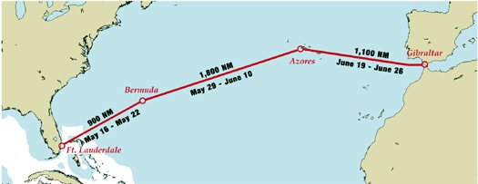
We're planning our move from the Caribbean to Europe. Most of the research (Cornell etc.) are for routes in which the wind is steady and either abeam or astern. But for a power vessel, the routes through high pressure areas with little wind at all seem at first glance to be better - less fuel use with less hobby-horsing and a quieter ride.
This seems to be almost opposite criteria to the (gentle) sailing routes!
I could say that the power boater wants to aim at the high pressure areas, while the sailor typically wants to aim somewhere between the high and low pressure areas (ignoring currents!).
One option is to engage a weather router familiar with the whole northern Atlantic AND understands the needs of power boats vs sailors (both want to avoid the worst weather of course). Does anyone know/recommend one?
We will of course self-route using Gribs and/or forecasts and trying to steer into the highs. Offshore, Iridium GO + Predictwind seems to have lots of supporters. Inreach are cheaper but don't have Grib download, only more localised forecasts which would appear to be less useful. Does anyone have other options for the whole northern Atlantic? Also for forward route planning and knowing when to leave, how do people look at data from previous years - I'm finding it hard to source historical data...
 .
.") you've essentially picked your line beforehand and weather routing is more a daily check and minor change.
you've essentially picked your line beforehand and weather routing is more a daily check and minor change.
 ).
). .
. ):
):
 I did think of a little 18hp diesel outboard, but they're sooooo expensive!