Furuno and Navionics

The friendliest place on the web for anyone who enjoys boating.
If you have answers, please help by responding to the unanswered posts.
I know that how? Because just a few days ago I received an email from Navionics offering the same charting software for my Simrad MFD just the same as always. No change from past practice. There has been tons of unfounded speculation based on preconceived notions about what Garmin is going to do.

You are extrapolating that because you can get an update today they will offer you one tomorrow as well. When Navionics was independent their business depended on that revenue stream. Now it does not, and Garmin has an interest in keeping it proprietary. Garmin also has a history of abandoning users of products they acquire, and even their own products. Active Captain and Delorme are recent examples.

You are right, good if you are a Garmin fan, not so good otherwise.
 
But,Twisted, with the incorporation of Navionics, isn't the net that what will be seen on the Garmin screen will be the same as on non-Garmin MFDs? Perhaps the annual subscription price will be more but we (I) don't know that. I see this as a positive for Garmin owners, that is, bei g stuck with charts that are updated only twice each year. I would never have considered a Garmin suite before this change.


I think a future Garmin will look much like a past Navionics chart on a non-garmin MFD. But in areas where C-map is better, or where CHS is better, or where Admiralty charts are better, or where Navionics doesn't even have charts, other things will be better, but not available on a Garmin device.


But I think in the US, none of this matters because everyone's charts are based off of NOAA, and are quite good. It's outside the US where having a broad chart selection is an advantage. Garmin has always only had garmin. I gather they are pretty good, and surely better with the addition of Navionics. But are they good enough to be the ONLY chart source available to you? Not for me.


I think it's unfortunate that Navionics is becoming less and less available. First it was dropped from Coastal Explorer. Now it's being dropped from Furuno. But neither is fatal. It would be interesting to know the real reason behind both, but I suspect we will never know.
 
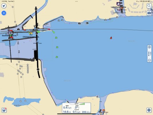
Ok. Here is the information I received from Nobeltec Time Zero. The tech there was very helpful.

Thanks for the update - good information.

Were they able to clarify the free vs $500 issue?
 
Thanks for the update - good information.

Were they able to clarify the free vs $500 issue?

I didn’t ask them the difference in noaa charts and the $500 noaa plus usace charts. I have to email them some coordinates so will ask them when I do.
 
I didn’t ask them the difference in noaa charts and the $500 noaa plus usace charts. I have to email them some coordinates so will ask them when I do.


Ummm.... I hadn't appreciated the difference between NOAA Raster ($0) and NOAA Vector plus USACE charts (either $0 or $500?) in your image post #43... compared to what we'd been using, where I've not noticed a USACE connection in the description before.

I'd suspect having the USACE info for your area would be a good thing.

-Chris

I agree, if the surveys are current. It does bring up a thought. Navionics uses crowdsourcing to augment the USACE data, pulling the information from readings gathered on chart plotters and transmitted to them.

Crowdsourcing is the best answer for the interior rivers. I would imagine most of the USACE focus would be on the “navigable waterway” portion of the rivers, though I have nothing to base that on. It sounded to me like this will also be Furuno’s approach. We will see how that works out.
 
I went to look closer at that... the filename referenced is MWVUSAMAP15.2 (a different filename format than what I have installed in TZ)... but it points to a download of the same current SDUS00VS57MAP.18.dbv NOAA vector charts we already have installed.

https://download.mapmedia.com/vector/SDUS00VS57MAP18.dbv.zip

The description says it includes:

Description : USA - East Coast & Gulf of Mexico, Puerto Rico, US Virgin Islands, Port Au Prince; La Petite Anse; Gonaives in Haiti and American Great Lakes, USA - USACE Inland Rivers - Allegheny River, Mile 0-15 - Arkansas River, Mile 0-444 - Atchafalaya River, Mile 0-118 - Black Warrior-Tombigbee Rivers, Mile 0-393 - Cumberland River, Mile 0-381 - Green River, Mile 1 -108 - Illinois River, Mile 0-322 - Kaskaskia, Mile 2 to 36 - Kanawha River, Mile 0-91 - Lower Mississippi River, Mile 236-951 - Missouri River, Mile 0-735 - Monongahela River, Mile 0-128 - Ohio River, Mile 0-981 - Ouachita River, Mile 5 to 338 - Red River, Mile 0-237 - Tennessee River, Mile 0-652 (Including Tellico, Hiwassee, Clinch and Emory Rivers) - Tennesse-Tombigbee Waterway, Mile 218-450 - Upper Mississippi River, Mile 0-866

BUT... none of the inland rivers will display for me. Our TZ is older than dirt (2.0.2) though, so it's perhaps possible the USACE info is somehow encoded in a way our old system won't display it.

Which may mean somebody with a newer TZ could see what's there, maybe post a screen shot of your area... if it does indeed show up.

Have to admit, I haven't replaced our old v2 TZ only because I was expecting to hang on until I need to replace the ship's laptop too. Ours is one we put in service in early 2010, still works well, so...

Edit: I've asked TZ tech support why I can't see that data...

-Chris
 
Last edited:
Crowdsourcing is the best answer for the interior rivers. I would imagine most of the USACE focus would be on the “navigable waterway” portion of the rivers, though I have nothing to base that on. It sounded to me like this will also be Furuno’s approach. We will see how that works out.


I can imagine crowd sourcing to be a powerful tool... but I can also imagine a whole load of crap that results... if there aren't strict controls on factors like transducer depth below waterline, sample time relative to actual tides, and so forth.

Of course I don't know anything about how the various companies are implementing/managing the whole idea...

-Chris
I've also wondered about the data quality. It would be good to know how the data are verified before trusting soundings based on crowd sourced data. Time and date shouldn't be too hard. The data collection could have both depth and standard GPS "sentences" that have universal date and time. Transducer depth below the water surface would not be so easy to control. There is also what frequency and the gain settings which can affect depth soundings over soft bottoms.

I wouldn't expect a single pass by a recreational boat to be anywhere near as accurate as a single pass by a NOAA or USACE survey vessel. But multiple data collections from numerous recreational boats over the same area, averaged with outliers thrown out, might be accurate enough. And for river bottoms or other areas where soundings change frequently may be more accurate that official surveys months or years old.

I just don't know enough about it to know how much I trust it.
 
As for crowd sourced data, when I saw how powerful Furuno’s multi beam sonar was - much more advanced than Garmin- combined with the precision of their SC20 gps compass, I thought they should crowd source those user generated charts.

https://www.furunousa.com/en/Company/News_Room/2021_pbg

If so, the accuracy is there and there is no “junk.”

“ TZtouch3's PBG incorporates inertially stabilized and tide-compensated calculations that result in highly accurate bottom mapping previously available only with elaborate, survey-grade acoustic measuring systems. ”

I’d really want access to that. And we’d soon have charts of various inlets etc. fisherman would want too, though that’s not my use case.

Maybe pop up user generated “alerts” on a different layer on the chart, much like Waze does.
 
Last edited:
I believe the Navionics crowd sourced data is also tide and transducer depth compensated. At least on Raymarine equipment, those items must be available and are sent with the uploaded data. On the other hand thew warn "not for navigation" anytime you call it up.

What would be nice to have would be some color put on the source data, for example the number of samples it is derived from and average age. Some areas I'm quite sure have hundreds of passes, others perhaps only one, you would not treat them the same if you knew the difference.
 
Description : USA - East Coast & Gulf of Mexico, Puerto Rico, US Virgin Islands, Port Au Prince; La Petite Anse; Gonaives in Haiti and American Great Lakes, USA - USACE Inland Rivers - Allegheny River, Mile 0-15 - Arkansas River, Mile 0-444 - Atchafalaya River, Mile 0-118 - Black Warrior-Tombigbee Rivers, Mile 0-393 - Cumberland River, Mile 0-381 - Green River, Mile 1 -108 - Illinois River, Mile 0-322 - Kaskaskia, Mile 2 to 36 - Kanawha River, Mile 0-91 - Lower Mississippi River, Mile 236-951 - Missouri River, Mile 0-735 - Monongahela River, Mile 0-128 - Ohio River, Mile 0-981 - Ouachita River, Mile 5 to 338 - Red River, Mile 0-237 - Tennessee River, Mile 0-652 (Including Tellico, Hiwassee, Clinch and Emory Rivers) - Tennesse-Tombigbee Waterway, Mile 218-450 - Upper Mississippi River, Mile 0-866


Ummm... I was having a brain phart. The TZ tech support guy gently suggested I might like to select VECTOR charts if I wanted to look at VECTOR chart data.

Duh!

Anyway, now that I'm over that self-induced hurdle... sure enough I've got Tennessee River charting within TZ. It looks pretty much like your C-Map chart pics. Not like your Navionics pic.

Brings up another thought or three. First, is that the USACE charting included in the MapMedia file is NOT the same thing as the USACE "recent survey" color highlighting that we've described within AquaMap.

In the latter, color shading is overlaid onto the vectior chart to indicate various depths as discovered on their latest surveys. IOW, in AQ along the east coast we're not seeing basic USACE charting data, just the survey data... overlaid on whatever AQ uses for coastal charting. (Would be similar to survey color coding overlaid on a NOAA vector chart.)

And then I guess what AQ uses for their Inland Rivers chart segments is based on the USACE charting data, but I didn't see any color shading to suggest recent survey overlays on top of that. Didn't look extensively, though. And the chart segment I picked at random to have a quick look may not have been impacted by recent depth survey data anyway.

All that said... the Furuno/TZ file with Inland River charting -- the VECTOR file (Duh!) was free.

-Chris
 
I believe the Navionics crowd sourced data is also tide and transducer depth compensated.

I could see a way to compensate for predicted tides (time related to predicted tide data); I'd think a few more orders of magnitude difficult to compensate for actual tides.

And I wonder how a company could "enforce" reporting the correct transducer depth setting.

Don't mean to say impossible, just recognizing that it's not as easy as just selling the equipment and then waiting for the crowd to start sourcing.

-Chris
 
I believe the Navionics crowd sourced data is also tide and transducer depth compensated. At least on Raymarine equipment, those items must be available and are sent with the uploaded data. On the other hand thew warn "not for navigation" anytime you call it up.

What would be nice to have would be some color put on the source data, for example the number of samples it is derived from and average age. Some areas I'm quite sure have hundreds of passes, others perhaps only one, you would not treat them the same if you knew the difference.

That’s why I imagine they would require it to be linked with their satellite compass, which is incredibly accurate and has heave protections. Plus their side scan sonar does 50 pings per second with a much wider beam than others, which are 1 ping and narrow.

If so mandated, nothing would come close and it would be as they state the same level of accuracy as surveying equipment.
 
Ok, here is the info I got on the mysterious $500 file. This quote of from TimeZero.

“The NOAA chart you referenced is not actually able to be purchased and does not need to be as the chart does not have an unlock code requirement. You can just download and install all of the NOAA charts from our site. The Furuno site is probably listing it at the standard mega wide chart price as a placeholder.”

So….it is free.

As far as the crowdsourcing, Navionics has done it for years, and I have found it to be reliable. I can’t imagine running with the NOAA charts only on the river system. There just isn’t any depth info to speak of. I received chart screen prints for five places. Our home port, the TomBigbee, the Mobile river, Mobile Bay, and the Chesapeake by Kent Island. Mobile Bay and the Chesapeake were the only ones with sufficient enough depth data for me. The rest were basically the same view you would get off of a highway map with depths at the edge of the navigation channel.. The screenshots of the Navionics chart showed ubiquitous depth readings.

Time Zero did say they were going to come out with better charts,,but didn’t say when. Which raises the question for me. What do people use on the rivers of they don’t use Navionics? Furuno must not have a large installed base on the river system, which is a little odd to me because of their popularity with the fishing crowd. I suppose seeing fish with sonar, and birds with radar, outweighs grounding your boat. :)
 
Ok, here is the info I got on the mysterious $500 file. This quote of from TimeZero.

Time Zero did say they were going to come out with better charts,,but didn’t say when. Which raises the question for me. What do people use on the rivers of they don’t use Navionics? Furuno must not have a large installed base on the river system, which is a little odd to me because of their popularity with the fishing crowd. I suppose seeing fish with sonar, and birds with radar, outweighs grounding your boat. :)

I’d like to know that, too. I use mostly Aquamap but it’s not much more detailed than C-Map on the TN river—at least to the extent I’ve explored it.
 

Attachments

  • 3AE938D7-6ED5-4A6D-977F-F25BCAAB4D0A.jpg
    3AE938D7-6ED5-4A6D-977F-F25BCAAB4D0A.jpg
    82.6 KB · Views: 25
For what it's worth, my understanding is the the vast majority of inland commercial traffic uses the Coastal Explorer RNC product. If you have watched TimBatSea's YouTube videos, you will see that all the tugs he runs use CE.
 
That’s why I imagine they would require it to be linked with their satellite compass, which is incredibly accurate and has heave protections. Plus their side scan sonar does 50 pings per second with a much wider beam than others, which are 1 ping and narrow.

If so mandated, nothing would come close and it would be as they state the same level of accuracy as surveying equipment.

You can really only used predicted tides for correction, actual is too sparse to be useful. How does the satellite compass affect accuracy? Most of the structured sonar implementations seem to be AHRS stabilized, position accuracy is the limit of GPS, it is unclear to me that even a few degrees of directional accuracy would have much affect.
 
You can really only used predicted tides for correction, actual is too sparse to be useful. How does the satellite compass affect accuracy? Most of the structured sonar implementations seem to be AHRS stabilized, position accuracy is the limit of GPS, it is unclear to me that even a few degrees of directional accuracy would have much affect.

More accurate is in regards to crowd sourcing, where they use magnetic heading compasses.

My guess re accuracy as they use four satellites for location, they can tell whether or how much the boat is healing and hence whether that impacts the depth readings as the transducer is at different angles.
 
Furuno must not have a large installed base on the river system, which is a little odd to me because of their popularity with the fishing crowd. I suppose seeing fish with sonar, and birds with radar, outweighs grounding your boat. :)

In most areas, fishermen have their own preferred charts it seems which are for their local fishing and none of the charts discussed here. Someone was showing me one the other day for flats fishing in FL and comparing it to Garmin and the difference was amazing.
 
Also, the more “detailed” charts are often just contour line interpolations between limited data points making them appear more accurate than they are.

Fisherman can generate their own detailed charts.
 
Last edited:
In most areas, fishermen have their own preferred charts it seems which are for their local fishing and none of the charts discussed here. Someone was showing me one the other day for flats fishing in FL and comparing it to Garmin and the difference was amazing.

Yep, I figured that, particularly for the professionals.
 
Also, the more “detailed” charts are often just contour line interpolations between limited data points making them appear more accurate than they are.

I use to watch the depth finder, versus the chart as a matter of course, up here. I think most would be amazed at just how accurate they are. I bet they are taking every reading stored on the plotter, perhaps thousands, and adding them to the database after throwing out obviously bad ones and adjusting for tide or pool level.
 
Where I have checked them, I've found the Navionics crowd sourced to be accurate - more accurate that the official charts. I imagine all brands have this now, Raymarine allows you to make your own bottom chart in real time. Still don't see how heading matters much, heel for side scanning but that is corrected by the AHRS, not compass. Position of course, but any modern receiver is tracking many satellites.
 
Where I have checked them, I've found the Navionics crowd sourced to be accurate - more accurate that the official charts. I imagine all brands have this now, Raymarine allows you to make your own bottom chart in real time. Still don't see how heading matters much, heel for side scanning but that is corrected by the AHRS, not compass. Position of course, but any modern receiver is tracking many satellites.

I think you are right on the ahrs for the heave. I read the MEMS sensor for the AHRS has only started moving into transducers and before that it was only in the sat compass, according to Furuno. The DFF-3D multibeam sonar system now employs MEMS in its transducer.

But I would think accurate heading is very important for SIDE sonar; otherwise, how do you know which area is getting mapped as the width is 120 degrees and up to 650 feet from the boat. Without accurate heading, how do you know which 120 degrees is being mapped?
 
I just received the new Garmin Navionics Vison+ for the US south today. Set up the new Garmin 923XSV on the bench. Added the card and then linked it to my phone for the initial update. Set up was pretty easy. The Charts look exactly like Navionics with a few things added. I dont remember regular Navionics having photo icon you can click on for various things such as Marinas etc. I think it has a little Active Captian added in the mix as well.

Not sure other systems are like this but when coupled to your phone you can view the plotter screen on the phone. But you can also pan and zoom your plotter screen using your phone. Its all synched up and nearly instant. I thought that was neat. It actually seems easier to pan and zoom using your phone almost like a mouse.

Unbelievably..I got two orders in. It looks like it somehow doubled the order ( I did pay for 2 but did not notice). If anyone needs the US South and has a compatible Garmin Plotter I am going go post it for sale for what I bought it for. Much less than retail fyi.
 
Just one man's opinion, BUT ...

1) If Furuno is going to depend on crowd sourced information, they are going to need a crowd. Their new transducer combo with TimeZero has by far the widest field captured. Nifty. But when I glanced at it all the cost of TimeZero, and transducer was about the cost of a 16 inch MFD. The capability is new, so few will have the transducer. The cost of the package is high so many won't spring for it.

2) For at least the Simrad C-Map version of personal bathy data, its not all that easy. You collect data. Save it to a chip. You need to pull it up file by file to use it. Chip by chip. The width of the field of data collected is narrow. You have to make an effort to do the uploading. It appears most are keeping it personal rather than uploading to be shared. There is very little data out there that I can see for popular spots. It seems fishermen are not uploading their collected data on their secret favorite fishing holes.

3) Look at some CMOR YouTubes. It seems to depend on crowd sourced data. In active places like Florida there are sparse patches where there is data, and large sections without it.

It is nifty technology and seems to probably have a great future. If you want to buy something to plug in now with broad coverage, crowd sourced info doesn't seem to be there yet. I have not looked at the Garmin / Navionics crowd sourced stuff so maybe that's an exception.
 
But I would think accurate heading is very important for SIDE sonar; otherwise, how do you know which area is getting mapped as the width is 120 degrees and up to 650 feet from the boat. Without accurate heading, how do you know which 120 degrees is being mapped?

I don't know when it happened, but my transducer (Raymarine) has a MEMS and maintains an AHRS, installed in 2019 and a couple fo years old tech then.

To map accurately, you need to know COG and position more than heading. Unless the two are greatly different. A MEMS produced heading should be within a couple of degrees or better and that will not result in much error.

I agree with you. If up to 25’ off is acceptable.

You have a relatively recent system. I’m suggesting those that are 10 years or older shouldn’t be crowd sourced for side scan as they will be inaccurate but I doubt they would have side scan. Maybe just depth readings which is fine I’d think.

So the stated accuracy of the heading indicator in your Raymarine RV-212 transducers is 2 degrees (which seems remarkable). The best Garmin 9 axis heading indicator is 2 degrees, the model below that is 3 degrees. A flux gate compass - who knows if it is free of interference etc., least accurate. The Furuno Scx-20 sat compass is less than 1 degree.

Each degree of inaccuracy at the max side sonar range will put the position off by 12’, if my algebra is accurate, which it may not be. For objects closer less variation. For directly below, doesn’t matter.

Hence the statement that the Furuno scx-20 and their side scan can be the same accuracy as the surveyors.

For crowd sourcing, that would be reliable.

I’ll stop now on this topic as I probably agree with you and it’s just an academic discussion that might be best offline.
 
Last edited:
Just one man's opinion, BUT ...

1) If Furuno is going to depend on crowd sourced information, they are going to need a crowd. Their new transducer combo with TimeZero has by far the widest field captured. Nifty. But when I glanced at it all the cost of TimeZero, and transducer was about the cost of a 16 inch MFD. The capability is new, so few will have the transducer. The cost of the package is high so many won't spring for it.

2) For at least the Simrad C-Map version of personal bathy data, its not all that easy. You collect data. Save it to a chip. You need to pull it up file by file to use it. Chip by chip. The width of the field of data collected is narrow. You have to make an effort to do the uploading. It appears most are keeping it personal rather than uploading to be shared. There is very little data out there that I can see for popular spots. It seems fishermen are not uploading their collected data on their secret favorite fishing holes.

3) Look at some CMOR YouTubes. It seems to depend on crowd sourced data. In active places like Florida there are sparse patches where there is data, and large sections without it.

It is nifty technology and seems to probably have a great future. If you want to buy something to plug in now with broad coverage, crowd sourced info doesn't seem to be there yet. I have not looked at the Garmin / Navionics crowd sourced stuff so maybe that's an exception.

I am using the crowd sourced term, though Navionics may call it something different. I had Navionics, and the feature to upload data is something you can turn on and off, if I remember correctly. The way I think about it, transducers send out impulses rapidly, they are then rapidly received and sent to the MFD, smoothed for display, and filed with location info, from all source input to the MFD, creating a massive amount of data. That data is transmitted when the boat is connected to the internet or via chips. However, massive data isn’t isn’t a big deal anymore in the data and connected world. That information is collected, probably anonymized, compared to previous readings for the location already received, outliers thrown out, averaged in, and added to the charts.
 

Latest posts

Back
Top Bottom