Milton

The friendliest place on the web for anyone who enjoys boating.
If you have answers, please help by responding to the unanswered posts.
Just for kicks, we have a space for one boat on our dock if someone wants to evac Fort Myers area with their boat. No charge, only 20 amp to that slip, but it's available if anyone wants to move to a safer area for a few days until the storm passes. This particular slip is limited to 4.5' draft though.


Best of luck to everyone with this one. We're just expecting a lot of rain here.
 
Boat prep is done. Batteries are topped off to 100% via generator today while I was prepping since shore power is still out. This time I secured the fridge so I am just drawing enough for the Wifi/internet, bilge and dry bilge, cameras and just a few other items. That gives me 10 days of monitoring the boat via internet from home. I installed an extra camera in the bilge. So I can monitor the aft deck area, Cabin and Bilge via camera that can pan/tilt and zoon and turn on lights. Can also remotely monitor battery and electrical.

We had 9 foot surge actual during Helene and I had about 2-3 more feet of scope remaining in my lines. Today I added four 50 foot lines to the 4 aft cleats and routed them across the dock to the pilings on the far side of the walkway. That will give additional scope for additional rise and fall but still keep the boat centered. I feel I could go to a 15 foot surge.

House is done prepping with the Lexan panels, 2 generators, plenty of fuel, lots of Ryobi and Milwaukee 18v lights and fans and about 20 batteries. 36 volt lithium golf cart with a 1500 watt inverter charged...and on and on...

We are 32 feet about sea level. So for us its just a wind issue. But we are likely staying. I am in New Port Richey as well.
 
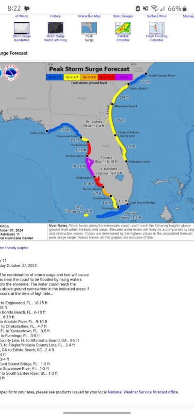
For those in the bleachers who think you just move your boat out of harms way, consider this. Milton evolved from Storm 14 just 48-hours ago. 48-hours from now he will hit central Florida with Cat 3 winds and 10-15 foot surge (the purple zone on the attached).

Where do you go? Or do you just say to hell with it -

Peter
 

Attachments

  • Screenshot_20241007_202218_DuckDuckGo.jpg
    Screenshot_20241007_202218_DuckDuckGo.jpg
    76.7 KB · Views: 14
For those in the bleachers who think you just move your boat out of harms way, consider this. Milton evolved from Storm 14 just 48-hours ago. 48-hours from now he will hit central Florida with Cat 3 winds and 10-15 foot surge (the purple zone on the attached).

Where do you go? Or do you just say to hell with it -

Peter
The hell with it....lol. Too many other things to do that are higher priority.
 
If Milton makes landfall Wednesday evening at Tampa Bay or just north of Tampa Bay, my city of St. Petersburg will be toast.

My county, Pinellas County, is a low-lying peninsula bordered on three sides by water. It has hundreds of thousands of homes at risk of flooding. Close to half of our 961,000 county residents have been instructed to evacuate, from Tarpon Springs down to Pass-a-Grille.

All businesses in Flood Zones A, B and C have been ordered to close this morning by 7 a.m. That's half the county.

The numerous waterfront and canal neighborhoods on Tampa Bay still have enormous piles of Helene debris lining their streets. The piles contain ruined appliances (refrigerators, washer/dryers, heat pumps, etc), kitchen cabinets, carpets, couches, drywall, and endless rows of black trash bags.

If Milton hits Tampa Bay or slightly above Tampa Bay, that debris is going to be scattered far and wide, including into our canals and waterways.

And the barrier islands will be rendered unrecognizable. Thousands of families will lose their homes in the storm surge. Power will be out for weeks, in this unbearable heat.

This one is going to be a rough one.
 
I'm square in the eye of this, and just pray for some relief. Helene took the contents of my home, but the boat survived quite well.

Hope others in Tampa Bay can get through this with something to come home to.
 
I really feel for you guys. I'm hoping for the best. Hopefully the eye will go south of St. Pete and send the surge into less populated areas.
 
Tuesday morning now, landfall predicted late Wednesday night / early Thursday morning. The cone has narrowed considerably, but even now, 36 hours before landfall, it ranges across 150 miles of coastline, from just below Cedar Key to Sanibel Island.
 
Will be deciding whether to stay or leave with the afternoon updated forecast. We're far enough inland that the storm surge shouldn't be an issue. It's more about whether the track stays North of us or moves South.

Have made several trips to Tarpon Springs over the last eight years with the trawler. This is just so hard to watch, the places that you cruised through getting ready to be devastated. Have friends scattered from Fort Myers to Crystal River along the coast. This is truly heart breaking to see what's coming towards them!

For my friends along the path of Milton's destruction, please stay safe!

Ted
 
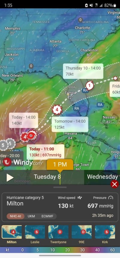
Can someone explain the discrepancy of the reported strength versus what Windy reports? I’m seeing 50+ knit winds and 20ft seas. Neither sounds accurate.
IMG_2445.jpeg
 
So we beat on, boats against the current..." Boy you have a good memory. And a 1st Ed of Farewell to Arms now. Not worth as much as you'd think though. Funny, when we bought our boat and sailed it along Long Island's north shore, I wished I had that edition of GG with me, just for literary sentimental purposes.

Coincidentally we're getting off a cruise ship in Miami at the moment. All our cat and hobie sailing excursions were canceled, bad weather and rain. We're on the other side of course (Bahamas) but glad we're heading home. See you later Milton.
Taking this reminiscence to private messaging
 
Can someone explain the discrepancy of the reported strength versus what Windy reports? I’m seeing 50+ knit winds and 20ft seas. Neither sounds accurate. View attachment 158911
Understand that the area of hurricane force winds is about 50 miles across. Not sure if Windy is able to focus that precisely. Also, the eye may have much lower winds, so Windy could be averaging the eye with hurricane force winds.

Ted
 

Question: Why reported wind speed of hurricane is much higher than value forecasted by Windy?​

Answer: Windy displays ECMWF or GFS global forecast model. Neither of them is capable to predict exact peak values.​


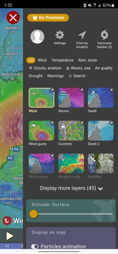
Windy has a decent hurricane forecast tracker (see top right corner of the menu screenshot attached). My guess is their algorithm doesn't work for extreme weather.

Right now, Milton is headed just south of Tampa Bay to the barrier islands near Sarasota. Tampa itself is at serious risk. Of note, the Euro model shows the track slightly north of GFS with a swish-shot up Tampa Bay. The area has not had a direct hit from a major hurricane since 1921.

For us, as long as the roof stays on, we can rebuild. There were a lot of lessons learned from hurricane Andrew in 1992, one of which was the importance of maintaining a structures envelope. Once the windows and doors blow out, the pressure gradient lifts the roof with a kill shot to the building.

You learn a lot of interesting stuff when living in Florida.

Peter
 

Attachments

  • Screenshot_20241008_133541_Windy.jpg
    Screenshot_20241008_133541_Windy.jpg
    107 KB · Views: 1
  • Screenshot_20241008_133552_Windy.jpg
    Screenshot_20241008_133552_Windy.jpg
    84.3 KB · Views: 1
Back
Top Bottom