Weather "Window" Advice Needed/Wanted

The friendliest place on the web for anyone who enjoys boating.
If you have answers, please help by responding to the unanswered posts.
No I don't...... but unfortunately most boaters I know think people with vastly superior knowledge than them are God-like when it comes to boating.

Yet these "captains" are neither all that safe or capable of good instruction.

So reviews have to be tempered with the right questions or acid tests.


But you are correct that references you trust are about as good as it gets...with other tid bits that may be important to you.

And please dont think I was making fun of you.....being both a professional pilot, professional captain, teaching captain and recreational boater for over 50 years....I get the connection of flying and boating...but really have to say that beyond some basics, they diverge so much in knowledge required that I usually never mention the connection anymore.
 
Last edited:
No danger of me over-estimating someone's knowledge that is relatively unknown to me. I respect experience and education, but I respect talent, judgment and integrity much more. (I know many experienced people who have been doing things wrong for many years.) And, I usually reserve judgment regarding talent, judgment and integrity until after personal contact and iteraction. (e. g. Most MD's are taken aback because I often question them and their recommendations--they are not God-like but many treat them like they are.) In any case, I find that I can learn alot from others--even the over-confident ones that exagerate their abilities.

Thanks for your comments.

Mastering a skill that demands physical and mental abilities regarding the control of machines is pretty much my life passion--flying, racing, boating, sailing--even running. All can benefit with the use of multiple coaches and teachers. Of these, the only "professional" level I can claim is the auto racing part--in all the others I am just an enthusiastic amateur.

Yankee's from New England are born skeptics. My family is from Portland, Maine--no possibility of me thinking any man is God-like. lol.
 
Last edited:
So, back to the conversation at hand. Are you staying or going?
 
We are going, but not until AFTER the low pressure system forecast for Tue-Wed moves on. We will depart when we see a three day window with less than 15 mph winds and less than 3 foot waves. As advised-if it is not fun--don't do it.
 
This is pretty simple - as RANGER42c said - play the wind and the tide. The bay will change as you move S to N in your case. East side until Choptank has very little options to tuck in. You could have light winds out of the S or N with opposing tide and get your first lesson on the Chesapeake chop!


Navigation is pretty straight foward - Load in a route, enjoy and don't overthink. As previously stated, make a list of tuck in marinas
 
Going north from Norfolk, look for winds from the south. Winds from the north will build waves given the long 100 mile plus fetch. Last year, we and several other boats waited in Hampton, VA for five days for the winds to turn around. We were rewarded with an easy voyage north. First stop was a terrific anchorage on the Indian River (Kilmarnock, VA), then Solomons Island, MD, then Galesville, MD, home marina. Crossing the mouth of tthe Potomac is not difficult if one chooses to traverse at slack tide. If you catch it right, it can be smooth as glass.
We are going, but not until AFTER the low pressure system forecast for Tue-Wed moves on. We will depart when we see a three day window with less than 15 mph winds and less than 3 foot waves. As advised-if it is not fun--don't do it.
 
There are a bunch of pretty and protected places to anchor along the western shore, and as you get further north, on the east as well. Get a copy of Chesapeake Magazine's Guide to Cruising Chesapeake Bay, it is invaluable. Illustrated too. For us, the anchorages are the real lure of the Chessie. A copy of Waterway Guide is helpful as well.
 
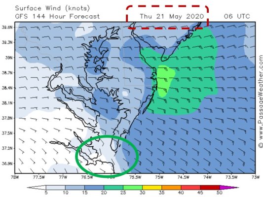
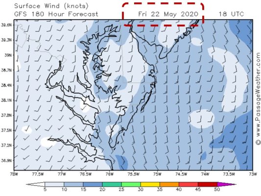
Forecast for next Wednesday is unchanged, but Thursday/Friday are coming into view. Still too far out to bank on, but they are encouraging. Attached JPGs are GFS by PassageWeather for 0600 UTC (1AM EDT) Thursday and 1800 UTC (1PM EDT) Friday. IF this forecast were to hold, earliest possible departure on Thursday would make sense - still breezy in the north, but forecast relative calm in southern reaches of the Chesapeake. Winds shift on Friday to out of the south. I have to say, I question the forecast as it goes from blowing stink on Wednesday afternoon (30-kts) to calm in a period of 12-hours, the "Thursday" chart below. But that's what the model shows at this point. Not impossible, and Wednesday's forecast has held remarkably steady. But still......

Norfolk HDG May 21 2020.jpg

Norfolk HDG May 22 2020.jpg
 
Last edited:
Possibly because of the passing tropical depression/storm forming near the Bahamas....expected to move NNE.
 
Now that "Arthur" is in clear view, planning on departing Norfolk Friday to make Deltaville. Wind OK..on is the stern. Wave size and duration (8-9) seconds OK. Probably some rain. Sat and Sunday OK. A little choppy north of Rappahannock on Sat.
Long day to Annapolis.

Forecast using Sail Flow and Wind Pro as well as NOAA. Some uncertainty regarding low pressure system/s stalled over KY/TN which will pass thru Fri.
 
Last edited:
Yes Friday is looking good as of now. Several years ago, I went from Chesapeake City to Hampton in two days. This was in a full displacement trawler. Checked my log, I put 23 hours on the engine. Includes going into Solomon’s for the night.

When this thread started I was in Osprey Marina. Now I’m in the Dismal Swamp waiting out the weather, like you. I’m thinking of an exit from the canal on Thursday to stage an early morning start out of Norfolk at 5:30 am and see how far I can get.

I am told the canals are great places to shelter from storms.

I am leaving from Albemarle and Chesapeak Canal, just east of Great Bridge Locks..looks like you may be the "pathfinder" north, being a few hours ahead. Stay in touch.

Particularly interested in conditions exiting Hampton turning north, with wind from the east.
 
Last edited:
I’ll make this easy for the OP.

I do not go out in my 47’ ocean capable boat, with my 20 seasons of open ocean boating in 25 knot wind conditions.

Pick another day.
 
I’ll make this easy for the OP.

I do not go out in my 47’ ocean capable boat, with my 20 seasons of open ocean boating in 25 knot wind conditions.

Pick another day.


That seems like an overly strict rule. To me, whether 25 kts is ok or not depends on a few things: How far am I going? Where is the wind coming from? Is the wind increasing or decreasing?

If the wind is blowing off shore and I'm not going out very far, the sea state is likely to be reasonable. And if I'm not going to be out there for all that long where fatigue becomes a concern, I'll probably go. If the wind is in a less friendly direction relative to the shoreline and my destination, leading to an unpleasant sea state, then it's a no go. In some places, a 25 kt wind from one direction is not much more than an annoyance for getting in/out of the slip, while a 25 kt wind from a different direction can mean 6 foot short period waves on the beam, which is solidly in the "bad idea" category for most of our boats.
 
I’ll make this easy for the OP.

I do not go out in my 47’ ocean capable boat, with my 20 seasons of open ocean boating in 25 knot wind conditions.

Pick another day.

Thanks.. I agree 25 knot winds would be unacceptable to me too.
15 knots are about my limit--depending on direction, wave height, and wave duration. Long 3 footers would be maybe OK, but even 3 footers with 5 sec duration probably not for me. My ideal is less than 2 foot and 8-10 second duration, with wind on my back. That is why I am delaying until Friday.

I did--see above---winds Friday-Saturday are around 10 knots. Are you saying Friday is no good???????????????????

Will delay again if forecast is incorrect. Per advice here, I have carefully looked for "shelters" in route on western coast, if needed. Biggest concern is the uncertainty of that low pressure center/front scheduled to be moving thru area Fri-Sat and chances of thundershowers.

Forecast for friday already changing (2PM Mon) just since this morning--now the forecase call for much higher winds 20 mph==waves only 2.5 ft with 9 sec duration.

As said, departure will depend on actual conditions which may change by Friday. The combo of Arthur and these low pressure fronts is very unpredictable.
 
Last edited:
Rule of thumb for the Chesapeake Bay during summer, from my father:

Be anchored or in a marina by 2:30/3:00 pm, every summer day.
Thunder storms pop up fast.

Should not matter to your trip, too early in the season.
Just posted for your summer yet to arrive.

Have a safe trip.
 
Rule of thumb for the Chesapeake Bay during summer, from my father:

Be anchored or in a marina by 2:30/3:00 pm, every summer day.
Thunder storms pop up fast.

Should not matter to your trip, too early in the season.
Just posted for your summer yet to arrive.

Have a safe trip.

Your father was a wise man.

I have been caught out in a "pop up" thunderstorm, crossing bay in a 30 ft sail boat. I was able to get sail down, but still the wind hit so hard, the boat heeled over 30 degrees. The water "sizzled" when lightning stuck maybe 100 yards away. Could not see a thing for about 5-10 minutes. Then it was gone. Not something I would want to do again. Hot, Hazy and Humid on the Bay is unstable air and likley conditions for a boomer.


The above youtube was the only ones I could find. The English Channel one shows Force 4 winds. The Tacoma one does not tell wind. Both show "enough" i.e. the most movement for me to take on a 8-10 hour long trip.

Friday, once out of the Elizabeth River and Hampton harbor area seems to be right at or maybe above the limit. Might pull into Hampton and wait till Saturday for run up the bay.
 
In addition to passageweather that I see others use here, I found Windfinder to be helpful for wind--although their wave data seems off. Sailflow was recommended to me and it seems very good. My favorite forecaster is Windy.com--pick wind or waves and just click on a location to get the data--present or future.

Using forecasts is tricky---different forecasters use different models. Forecasting is useful, but I think one needs to always be prepared for surprises.


https://www.passageweather.com/

https://www.windfinder.com/#10/37.1412/-75.9066

https://www.sailflow.com/

https://www.windy.com/?37.411,-75.868,10
GFS data is the underlying data for passageweather and windy. Same for NOAA. NOAA uses human oversight to interpret, online services use an algorithm. The challenge is the online graphics like windy and buoyweather give the impression of being much more precise than they actually are. None are very good at forecasting relatively small bodies of water like Chesapeake Bay and San Francisco Bay. Local forecasters do a decent job, but the offshore GFS models simply do not have that level of micro precision. They try, but in the end, they don't.

Looks like your wx window is shifting out a bit. Early Saturday looks good
 
I'm East of Belhaven this evening. With weather luck, Elizabeth City tomorrow night. Norfolk on Thursday night. Tentatively heading up the Bay to Crisfield early Saturday. May lose a day crossing Albemarle Sound if the weather isn't fit tomorrow. Would be nice if Friday nights weather pushed back 8 to 10 hours. Maybe we'll see each other in Norfolk. I'll be coming through the Dismal Swamp.

Ted
 
When it comes time to make your final go/no go decision, don’t forget that the best 24hr forecast available is the Terminal Area Forecast and a good old fashioned weather briefing from 1-800-WxBrief.
 
I tend to use the PredictWind app a lot. It has 4 wind models and shows them all in a table, which I like more than the color coded map.
 
When it comes time to make your final go/no go decision, don’t forget that the best 24hr forecast available is the Terminal Area Forecast and a good old fashioned weather briefing from 1-800-WxBrief.

Good advice. NOAA NWS does a good job..the best for short term info.

https://forecast.weather.gov/shmrn.php?mz=anz632&syn=anz600

There is quite a difference between the programs...especially for wave height.
 
Last edited:
https://s16.us-east-1.skyvdn.com/rtplive/HRBT1017/playlist.m3u8

Link to webcam from Hampton/Norfolk (I64) Bridge looking out into Bay..live
Above link only works on mobile phone. Below link to see larger on PC.


https://www.511virginia.org/

go to Virginia DOT--click on South Island Tower Cam on the Hampton Bridge (I64). They rotate it so sometimes facing north, sometimes south.

Lots of white caps today---consistent with 20 mph avg/30 mph gusts Force 5 "Fresh" Breeze.

My general rule is if there are more than just a few white caps Force 4 (Moderate Breeze)---no go. (I prefer Force 3=Gentle Breeze)

Friday still uncertain---pretty windy early--forecast to be tapering off at Noon. We will move up Elizabeth River from Great Bridge Lock to Norfolk Friday AM and take a look at the Bay then to see if we can make Deltaville before dark. (My info shows high tide at around 10:00 so I guess the tidal current is against northbound travel at Noon? I am learning here. ) If necessary, we can overnight in Norfolk or Hampton and take off Saturday, but I would like to be past the Potomac Saturday afternoon to reduce probability of running thru thunderstorms forecast further south on Saturday. If we leave from Norfolk on Saturday, I guess our destination would be Ingram Bay.
 
Last edited:
I'm East of Belhaven this evening. With weather luck, Elizabeth City tomorrow night. Norfolk on Thursday night. Tentatively heading up the Bay to Crisfield early Saturday. May lose a day crossing Albemarle Sound if the weather isn't fit tomorrow. Would be nice if Friday nights weather pushed back 8 to 10 hours. Maybe we'll see each other in Norfolk. I'll be coming through the Dismal Swamp.

Ted

If we end up leaving Norfolk early Saturday, we might be nearby for part of the trip. You will be going to eastern shore Crisfiled, we to western Reedville/Ingram Bay south of Potomac.

Donald and Dustin
 
If we end up leaving Norfolk early Saturday, we might be nearby for part of the trip. You will be going to eastern shore Crisfiled, we to western Reedville/Ingram Bay south of Potomac.

Donald and Dustin

Coming into Elizabeth city shortly after a fun crossing of the Albemarle sound. :nonono: Will probably fuel at Top Rack on Friday and then move to the Point Comfort anchorage for the evening. Do you have AIS?

Ted
 
Don't see a need for a professional captain unless one wasn't confident with his navigational skills, not confident in docking their boat, or just need additional crew.
 

Latest posts

Back
Top Bottom