mvweebles
Guru
- Joined
- Mar 21, 2019
- Messages
- 7,675
- Location
- United States
- Vessel Name
- Weebles
- Vessel Make
- 1970 Willard 36 Trawler
Weebles is on the hard in Chiapas MX, a little over halfway through the 5000 nm trek from Ensenada to our home near St Pete Florida. We will return to Chiapas in November or so and spend a few weeks doing repairs before heading south to Nicaragua, El Salvador, Costa Rica, and the Panama Canal which we'll transit in spring of 2025. We will head east to the San Blas islands. From there, we'll either continue to Colombia (Barranquilla area), or, more likely, head west to Bocas del Toros islands off Panama.
By far, the most challenging leg will be heading north up the Caribbean. Seas are routinely 6-9 feet at 7-ish seconds from the east so on the beam. Too much for our little 36-footer. Secondly, there are some piracy concerns along Nicaragua and Honduras' Caribbean coast.
Pilot Charts show May/June is the best period to head north on the Caribbean so I've been tracking weather for the last two months. Weather windows are indeed more prevalent now than when Muirgen (TF handle "Slowgoesit") headed north a month and a half ago, though they had been in delivery-mode for a while to get to their sight-unseen house they purchased in Florida. Plus their boat is significantly more tolerant of the normal heavy chop the Caribbean regularly dishes up.
Most likely route is from Costa Rica near Limon, an industrial city without cruising interest but is the northern most point of departure. From there, head to Providencia, 200 nms north. These Colombian islands are gorgeous and a welcome stopover. It's also where the cruising ends and delivery begins. While we'll learn a lot in the next year, the current thinking is Cheryll would leave the boat here and I'd have a friend accompany the rest of the way north on a pure beat to weather.
To avoid the piracy-risk off Nicuragua/Honduras border, current thinking is to head northeast to a small outpost "Seranilla Bank." This speck in the middle of the Caribbean has been disputed land for centuries so the current holder - Colombia - maintains a small garrison. It supposedly has an acceptable but not great anchorage.
The Plan B route would be to depart from Barranquilla Colombia area (see second attachment - chartlet) and head north with a stop in possibly Cayman Islands, stopover in Jamaica before touring Cuba's eastern end and into the Grand Bahama channel. This route was closer to Plan A until Jamaica had a flair-up in violence earlier this year.
Best case scenario would be finding another cruiser with whom to buddy boat and hopefully reduce security concerns. We've met a lot of people along the way - especially via the Panama Posse.
My point in posting this so far out is to give a sense of our approach to passage planning. Right now, the most critical tool I have is PredictWind weather subscription - our membership in Panama Posse gives a 20% discount which makes the hefty subscription a bit more palatable ($250/year for their standard membership, $500/year for their more granular membership that includes currents' modeling).
Next will be brushing up on OpenCPN to better read satellite photos. Charting in Las Perlas (West of Panama) and San Blas (East of Panama) are a bit unreliable.
Definitely looking forward to next phase of the "Lazy Delivery" from San Francisco to Florida.
Peter
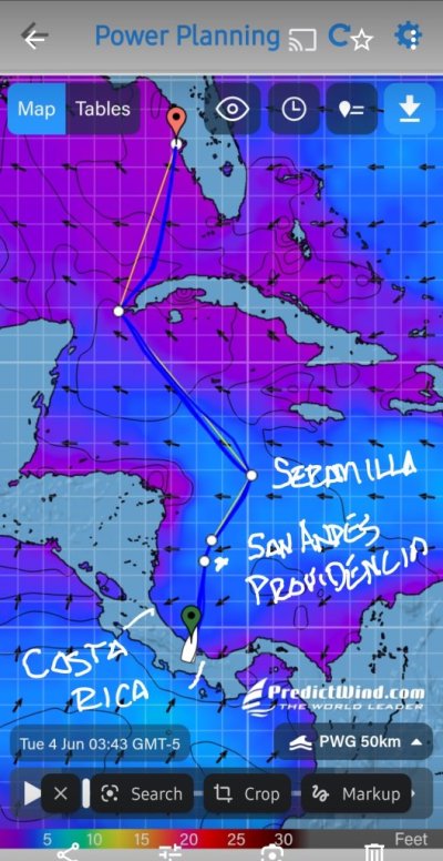
Attachments - screenshot from PredictWind showing conditions right now. This shows waves - purple is good. If we had left a couple days ago, prediction was for no worse than 3-foot waves at 6-7 seconds.
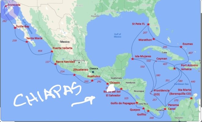
Second graphic is a general chartlet of the Caribbean with distances. Many options to head north, though few are great. We are not considering the eastern Caribbean islands.
By far, the most challenging leg will be heading north up the Caribbean. Seas are routinely 6-9 feet at 7-ish seconds from the east so on the beam. Too much for our little 36-footer. Secondly, there are some piracy concerns along Nicaragua and Honduras' Caribbean coast.
Pilot Charts show May/June is the best period to head north on the Caribbean so I've been tracking weather for the last two months. Weather windows are indeed more prevalent now than when Muirgen (TF handle "Slowgoesit") headed north a month and a half ago, though they had been in delivery-mode for a while to get to their sight-unseen house they purchased in Florida. Plus their boat is significantly more tolerant of the normal heavy chop the Caribbean regularly dishes up.
Most likely route is from Costa Rica near Limon, an industrial city without cruising interest but is the northern most point of departure. From there, head to Providencia, 200 nms north. These Colombian islands are gorgeous and a welcome stopover. It's also where the cruising ends and delivery begins. While we'll learn a lot in the next year, the current thinking is Cheryll would leave the boat here and I'd have a friend accompany the rest of the way north on a pure beat to weather.
To avoid the piracy-risk off Nicuragua/Honduras border, current thinking is to head northeast to a small outpost "Seranilla Bank." This speck in the middle of the Caribbean has been disputed land for centuries so the current holder - Colombia - maintains a small garrison. It supposedly has an acceptable but not great anchorage.
The Plan B route would be to depart from Barranquilla Colombia area (see second attachment - chartlet) and head north with a stop in possibly Cayman Islands, stopover in Jamaica before touring Cuba's eastern end and into the Grand Bahama channel. This route was closer to Plan A until Jamaica had a flair-up in violence earlier this year.
Best case scenario would be finding another cruiser with whom to buddy boat and hopefully reduce security concerns. We've met a lot of people along the way - especially via the Panama Posse.
My point in posting this so far out is to give a sense of our approach to passage planning. Right now, the most critical tool I have is PredictWind weather subscription - our membership in Panama Posse gives a 20% discount which makes the hefty subscription a bit more palatable ($250/year for their standard membership, $500/year for their more granular membership that includes currents' modeling).
Next will be brushing up on OpenCPN to better read satellite photos. Charting in Las Perlas (West of Panama) and San Blas (East of Panama) are a bit unreliable.
Definitely looking forward to next phase of the "Lazy Delivery" from San Francisco to Florida.
Peter
Attachments - screenshot from PredictWind showing conditions right now. This shows waves - purple is good. If we had left a couple days ago, prediction was for no worse than 3-foot waves at 6-7 seconds.
Second graphic is a general chartlet of the Caribbean with distances. Many options to head north, though few are great. We are not considering the eastern Caribbean islands.
Attachments
Last edited: