Tide and current info for coastal BC (not P&P)

The friendliest place on the web for anyone who enjoys boating.
If you have answers, please help by responding to the unanswered posts.

rsn48

Guru
Joined
Feb 18, 2019
Messages
2,019
Location
Canada
Vessel Name
Capricorn
Vessel Make
Mariner 30 - Sedan Cruiser 1969
So the Canadian government has shut down selling their Tide books. Aside from Ports and Passes (I already have my 2021), I like to use another source aside from my Garmin info. Where are you guys getting it? Links?
 
Thanks I will check out the links, I have a dedicated tablet for my boat, originally I ran Navionics on it as my primary chart plotter, but now I have my Garmin goodies, which of course now is also Navionics. I use it now mostly for Bluetooth transmission of music to my radio & speakers.

Roughly five years ago there was a small angry article in Pacific Yachting, the couple had gone to hole in the wall and had used Ports and Passes for their "timing" info to transit the nasty section. Unfortunately a minus became a plus or vise versa and when they began to head in they realized something was wrong. They tracked it down to an error in P&P. This article confirmed to me knowledge I already had, for critical areas especially the rapids always use more than one source.
 
The Tide Times app on my phone provides tides and current info for the US waters but looks like only tide info for Canada. Quick and easy to use.
 
The current atlas by tiny octopus is available as an app for phones but not computers. A one time payment, I just updated to 2021. There is a hardcopy as well. The phone app uses arrows of different size to indicate current flow. You can pick a date and times are every hour or so. It gives a good visual
 
I have this downloaded on my smartphone and it has 18 stations. When mine first comes on it shows the Vancouver tides which is what I'll use if I just want to get a general overview - are we in a high tide, low tide, middle... etc.

Where I want precision is with the rapids.
 
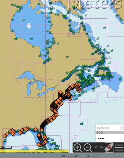
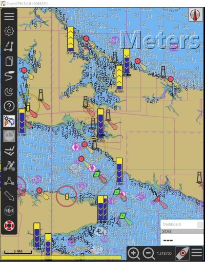
Opencpn

Every green dot is a tidal station, every orange dot is current
Click on them and they expand out into chart form so you can scroll past and future
 

Attachments

  • Annotation 2021-01-06 075710.jpg
    Annotation 2021-01-06 075710.jpg
    181.7 KB · Views: 40
  • Annotation 2021-01-0rr6 075710.jpg
    Annotation 2021-01-0rr6 075710.jpg
    184.7 KB · Views: 31
We have used AyeTides and have found them accurate throughout Desolation Sound and Broughtons. Data is available worldwide. Once you have the stations (both tide and current) added to your favorites you do not need cell reception to access the data. We also carry Ports and Passes and compare the two especially with currents. The only missing current station that we need is Whirlpool. It was there but disappeared this year. Hoping it will return. Otherwise a great app for $10.
 
Roughly five years ago there was a small angry article in Pacific Yachting, the couple had gone to hole in the wall and had used Ports and Passes for their "timing" info to transit the nasty section. Unfortunately a minus became a plus or vise versa and when they began to head in they realized something was wrong.
I remember reading that at the time and thinking the indignant anger was misplaced.

Who makes such a fundamental navigation mistake of reading a single line item and not being aware of tides and currents in the area?
 
It seems odd that CHS has gone to the trouble of compiling pdfs for these tables, then makes them available piecemeal, requiring about 1000 clicks and a bunch of work to download them. Put every region into a zip file for one click download, please.
 
Just discovered this if you go to this government website you can click on a link to the complete publication for an area and view the complete volume book for an area as a pdf which you can save as a PDF to you device.........:thumb::thumb::thumb:
 
Last edited:

Who makes such a fundamental navigation mistake of reading a single line item and not being aware of tides and currents in the area?


Not a criticism but I'm not sure what you mean here. Transiting rapids here in BC usually means going to the nearest recording point for the tides and then adding or subtracting minutes to get the exact time of slack. So if you were suppose to add 20 minutes but the written word says subtract 20 minutes and you act on that the results could be far worse than just irritation and anger.

Hole in the Wall and why timing is critical:


Trawler having a hard time with Hole in the Wall. When folks with faster boats talk about the safety factor with having speed available, often they aren't just blowing smoke up their derrière. I often will read some one debunking the speed is safety argument but in this video you will clearly see the trawler - its a charter by the way - is not having an easy go of it. And you will see an express cruiser blow by them and at that point you can see speed is most helpful in some of our local rapids. By the way, I think the trawler should have been more over to the right where the express cruiser is transiting. You can see the water on the right side is noticeable calmer than on the left.

 
Last edited:
Not a criticism but I'm not sure what you mean here. Transiting rapids here in BC usually means going to the nearest recording point for the tides and then adding or subtracting minutes to get the exact time of slack. So if you were suppose to add 20 minutes but the written word says subtract 20 minutes and you act on that the results could be far worse than just irritation and anger.

No schooling needed here, I’m intimately familiar with T&C and Hole in the Wall. You yourself said; “for critical areas especially the rapids always use more than one source.”

So, either that boater was a novice, in which case your words are even more important, or he was just being lazy.

And why mess with tide tables, when critical areas like Hole in the Wall have current specific tables?
https://www.tides.gc.ca/eng/data/table/2021/curr_ref/5100

Also no need for an “angry article” when publishing a simple heads up and notifying P&P would do.
 
I just ordered the Waggoner and P&P. The Waggoner goes all the way to Skagway.

Between P&P, Navionics and CE I have had good luck in the past and they all seem to be accurate.
 
Transiting rapids here in BC usually means going to the nearest recording point for the tides and then adding or subtracting minutes to get the exact time of slack.

That can be folly as well. Before there was a specific current table for Sechelt Rapids (Skookunchuck), Point Atkison tides, 50 miles away, were the reference point. Many recreational boaters blew that one.
 

Latest posts

Back
Top Bottom