- Joined
- Apr 15, 2008
- Messages
- 13,737
- Location
- California Delta
- Vessel Name
- FlyWright
- Vessel Make
- 1977 Marshall Californian 34 LRC
I just passed through there last Wed on my way back from 2 weeks on the Napa.


Wed morning, the fog was 1/4 to 1/2 mile visibility when I left the homes on Milton Rd. I thought it would burn off quickly but was surprised to find it less than 1/4 mile the entire stretch of the Napa including my approach to the Mare Island Causeway Bridge for an opening.
As I approached the Hwy 37 Bridge, it came into sight at about 0.2NM. Shortly after passing under Hwy 37, I made the initial call for an opening of the Causeway Bridge at 0.4NM without the bridge in sight. The bridge tender replied that he couldn't see me or the bridge traffic in the current thick fog, but to continue my approach and he'd advise. The bridge came into view at 0.17NM and I just held position north of the opening. After a minute or two, the bridge tender replied that he had me and the stopped road traffic in sight and verified my vertical clearance requirement. (It's actually 15'6", I fit in my 15' 8" covered slip, but I round up to 17' for bridge inaccuracies, my antennae and my own fudge factor.) With the fog as thick as it was, I was more focused on traffic anchored downstream on my radar than my vertical clearance. The tender assured me I had the room, so I proceeded, confident in his ability to perform his duties. I proceeded slowly, but was too busy to snap any pictures.
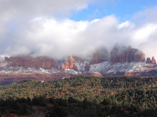
Further into the Mare Island Str the visibility picked up to close to a mile. Here is a shot from the Mare Island Straight as Giggitoni was texting me to watch out for fairies in the fog. (What can I say, this IS on the edge of the Bay Area!!)

As I passed the Carquinez Straight, the fog started to burn off and the sun poked through. I liked this perspective as I passed under I-80.

The final tally for the 2-week trip as I approached my marina:

Wed morning, the fog was 1/4 to 1/2 mile visibility when I left the homes on Milton Rd. I thought it would burn off quickly but was surprised to find it less than 1/4 mile the entire stretch of the Napa including my approach to the Mare Island Causeway Bridge for an opening.
As I approached the Hwy 37 Bridge, it came into sight at about 0.2NM. Shortly after passing under Hwy 37, I made the initial call for an opening of the Causeway Bridge at 0.4NM without the bridge in sight. The bridge tender replied that he couldn't see me or the bridge traffic in the current thick fog, but to continue my approach and he'd advise. The bridge came into view at 0.17NM and I just held position north of the opening. After a minute or two, the bridge tender replied that he had me and the stopped road traffic in sight and verified my vertical clearance requirement. (It's actually 15'6", I fit in my 15' 8" covered slip, but I round up to 17' for bridge inaccuracies, my antennae and my own fudge factor.) With the fog as thick as it was, I was more focused on traffic anchored downstream on my radar than my vertical clearance. The tender assured me I had the room, so I proceeded, confident in his ability to perform his duties. I proceeded slowly, but was too busy to snap any pictures.
Further into the Mare Island Str the visibility picked up to close to a mile. Here is a shot from the Mare Island Straight as Giggitoni was texting me to watch out for fairies in the fog. (What can I say, this IS on the edge of the Bay Area!!)
As I passed the Carquinez Straight, the fog started to burn off and the sun poked through. I liked this perspective as I passed under I-80.
The final tally for the 2-week trip as I approached my marina: