Interest in cruising the rest of Alaska?

The friendliest place on the web for anyone who enjoys boating.
If you have answers, please help by responding to the unanswered posts.

Want to cruise beyond SE Alaska?


  • Total voters
    50
  • Poll closed .
Alaska is big, but not THAT big. You've got big distortion there due to the mercator projection. This link is a more accurate overlay.
Alaska IS THAT big. Cut Alaska in two and Texas would be the 3rd largest state in the union!! At low tide, 4th......lol
 
Alaska IS THAT big. Cut Alaska in two and Texas would be the 3rd largest state in the union!! At low tide, 4th......lol


What moves in ahead of Texas for 3rd place when the tide goes out? Are you saying that at low tide, Alaska is 3x the size of Texas? The numbers I see say that AK is about 2.5 x the total area (including water) of TX.
 
Thanks for your comments ksanders.

There are many similar anchorages up & down the BC Coast & SE Alaska. Shoaling waters at the head of a fjord near a River or creek can be just good enough but quite tricky. ( examples like Kynoch Inlet, or the West end of Ford’s Terror come to mind.)
The rapidly shoaling ground makes it tricky to find the Goldilocks spot: Deep enough, but not so deep that the necessary scope puts you on the hard at low tide. It also means you want an anchor that bites and sets right where you put it, but we don’t need to go there in this thread ;-)

It sounds like conditions in PWS might be similar to those on the West Coast further South?

A lot of PWS is rocky, as in solid granite, and the shallower anchorages are sometimes debris slides or river drainages between the shore and the drop-off. If you go aground the highest probability is that you will hit a solid outcropping, there is very little soft in the Sound.

All you have to see is the steepness of the islands and you know it drops off fast, depths in excess of 3000' some places. Shallow anchorages with flat bottoms and good holding ground and protection are available, but not frequent. Those of us who frequent the Sound develop a catalog of preferred anchorages, but don't often share them because they tend to be quite small and only hold a few vessels before becoming crowded.

If you only have 200' of chain those anchorages are even further apart. Plan to anchor in 50'-150' of water.
 
What moves in ahead of Texas for 3rd place when the tide goes out? Are you saying that at low tide, Alaska is 3x the size of Texas? The numbers I see say that AK is about 2.5 x the total area (including water) of TX.
Well some Alaskans believe so! LOL But all in jest and fun....
 
A lot of PWS is rocky, as in solid granite, and the shallower anchorages are sometimes debris slides or river drainages between the shore and the drop-off. If you go aground the highest probability is that you will hit a solid outcropping, there is very little soft in the Sound.

All you have to see is the steepness of the islands and you know it drops off fast, depths in excess of 3000' some places. Shallow anchorages with flat bottoms and good holding ground and protection are available, but not frequent. Those of us who frequent the Sound develop a catalog of preferred anchorages, but don't often share them because they tend to be quite small and only hold a few vessels before becoming crowded.

If you only have 200' of chain those anchorages are even further apart. Plan to anchor in 50'-150' of water.

One place that reminds me of Alaska anchorages is Princess Louisa Inlet in B.C.
 
32' Gillnet boats are shipped on top of barges bound for AK. every spring. Look close you can see a lot of big stuff on top. I've seen mining haul trucks up there!

View attachment 111626
I've gotten quotes to barge it to Seward or Whittier. Estimates weren't quite what I paid for the boat, but close ;)
 
.

If you only have 200' of chain those anchorages are even further apart. Plan to anchor in 50'-150' of water.

Well, as I wrote before, we have ~115m (118m actually) of all chain rode. That translates to ~ 384 ft in old speak... so I think we have a decent bit of rode. We have had a fair bit of experience anchoring in many glacial fjords on the BC & SE Alaska coasts & have occasionally anchored in 30+m of water (~100ft). At those sorts of depths 3:1 scope would be plenty for most conditions.

There can be many challenges in finding suitable anchorages in these glacial fjords. Local knowledge is probably best but in the absence of that these sorts of discussions can be very useful.

Are there any good published guidebooks to PWS that you could recommend?
 
Weather eyes

Live version of 500 MB. It way up in the atmosphere, but its the stuff that moves the surface winds.

https://earth.nullschool.net/#current/wind/isobaric/500hPa/orthographic=-146.15,51.81,1552

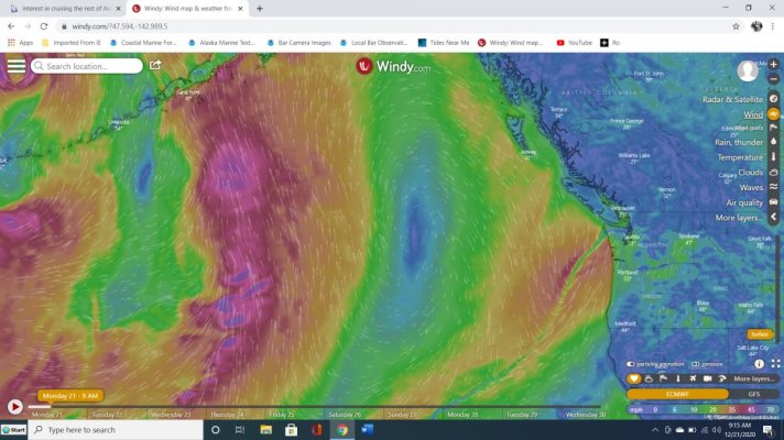
I'll post weather shots for the N. Pacific, nothing formal, just stuff that pops up. "How to get across the pond"

500 MB line is the keys to the kingdom. Storms track the 500MB highway by a few hundred miles on either side.

If you want to make the jump to AK. get familiar with the tools you need to understand the weather coming at you.

The current 500MB highway is no good for going NW or west. I would wait for it to drop south, get the lows below me. I have dropped south as I depart Dutch Harbor in the Aleutians and rode this highway to Seattle. (for another time)


Screen Shot 2020-12-21 at 8.46.12 AM.jpg

Screen Shot 2020-12-21 at 8.45.28 AM.jpg
 
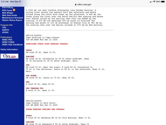
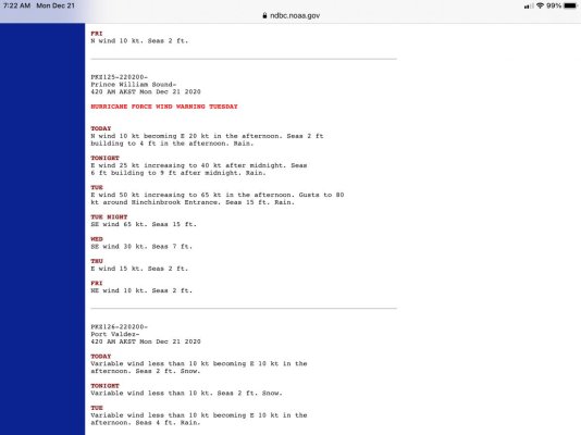
And todays forecast is
 

Attachments

  • D634B94E-5CE6-4517-A6A3-90F0CC0582D0.jpg
    D634B94E-5CE6-4517-A6A3-90F0CC0582D0.jpg
    103 KB · Views: 31
  • EB70921C-3256-402C-A889-2CFC43DDC3A9.jpg
    EB70921C-3256-402C-A889-2CFC43DDC3A9.jpg
    68.3 KB · Views: 25
AHHH Now I understand why Commercial Fish was always interested in MB and why NOAA would spend some time on it with their broadcast. Thanks for sharing.
 
Windy (winds)
 

Attachments

  • windy.jpg
    windy.jpg
    117.6 KB · Views: 40
Good forecast...they just started using Hurricane Force winds in the forecast. They use to say "Storm force Winds" anything above 65 knots. If you want calm, listen for Variable 5-15 kts.
The 500MB (jet stream) is aimed right at PWS they are in the bowling alley!
 
Well, as I wrote before, we have ~115m (118m actually) of all chain rode. That translates to ~ 384 ft in old speak... so I think we have a decent bit of rode. We have had a fair bit of experience anchoring in many glacial fjords on the BC & SE Alaska coasts & have occasionally anchored in 30+m of water (~100ft). At those sorts of depths 3:1 scope would be plenty for most conditions.

There can be many challenges in finding suitable anchorages in these glacial fjords. Local knowledge is probably best but in the absence of that these sorts of discussions can be very useful.

Are there any good published guidebooks to PWS that you could recommend?

Sadly the best guide for PWS is no longer in publication, "Cruising Guide to Prince William Sound" by Jim and Nancy Lethcoe was the golden guide. I saw one advertised on eBay for over $1000...

I keep thinking of simply photo copying mine and handing them out, no idea what the copyright rules are for out of publication prints.

It is amazingly useful, but there are still lots more anchorages to be found by poking about and watching your depth finder for adequate flat spots.
 
Are there any good published guidebooks to PWS that you could recommend?[/QUOTE]

Our Bible is “Cruising guide to Prince William Sound” by Jim and Nancy Lethcoe (Jim is no longer with us). They spent 25 years exploring the Sound in Summer and winters. Jim was a geologist. Whenever I explore a new area it’s my go to guide. Several times he has pointed out foul areas that were not on the charts. They point out if the anchorages are subject to Williwaws. The history they provide is wonderful. Twice a year we experience 18’ tides. As Jim suggests we normally explore shallow territory on low tide. More on Alaska’s Williwaw (williwaw.com).
 
Two other great reading books are "Stern and Rock-Bound Coast: Kenai Fjords National Park Historic Resource Study (Linda Cook) and Exploring Alaska's Kenai Fjords (David WM Miller).

The Stern and Rock Bound Coast was available as a free download but has become hard to find, it is also no longer available in print. PM me and I can send you a copy to download in a format of your choice.

Exploring Alaska's Kenai Fjords has an updated publication that covers from PWS to Cook Inlet, the first version stops at Port Dick in the Fjords (unfortunately I have that one).
 
Sadly the best guide for PWS is no longer in publication, "Cruising Guide to Prince William Sound" by Jim and Nancy Lethcoe was the golden guide. I saw one advertised on eBay for over $1000...

I keep thinking of simply photo copying mine and handing them out, no idea what the copyright rules are for out of publication prints.

It is amazingly useful, but there are still lots more anchorages to be found by poking about and watching your depth finder for adequate flat spots.

Yes Doug I keep thinking of converting it to PDF and giving it away as well. But... I don’t want to end up in court for doing a nice thing.
 
It would be nice to know what the laws are concerning reproducing out of print publications...

The Stern and Rock-Bound Coast was available as a free download, it was produced by the Park Service. Every chapter is a stand alone book mostly by different researchers, compiled as a research document. I think I can send that out without any risk...
 
Last edited:
Sadly the best guide for PWS is no longer in publication, "Cruising Guide to Prince William Sound" by Jim and Nancy Lethcoe was the golden guide. I saw one advertised on eBay for over $1000...


Still got mine. :)
 
So it would seem based on discussion is weather and range being the 2 most important factors.

It would also appear the easiest route would be from Elfin Cove to Yakutat, pass Kayak Island and into PWS via Hinchinbrook Entrance.

Is it safe to travel outside of Kayak Island or is there a passage behind it? I have also heard of the shortcut into Cordova?


The approach to the cut between Kayak and the mainland is shown as unsurveyed on the charts. And the inside of the cut is 3' at MLW. So unless you have a local guide, I'd plan on going outside Kayak.


Same with cutting through to Cordova. You would need a local guide, and even then it looks pretty questionable.
 
Thank you, it would appear that Stern and Rock-bound is fair use and the PWS guide is not. I still have mine too, 5th (and last) Edition :)
 
Same with cutting through to Cordova. You would need a local guide, and even then it looks pretty questionable.


Sooo tempting, it cuts a full day off the trip to Cordova. I studied it long and hard, rationalizing, " Well, it is marked, maybe at the top of a big tide..." Naah. Even the locals only do it in jet boats.
 
Just from looking at the charts, I wouldn't even try that shortcut to Cordova. Maybe with a local guide at high slack in calm weather.
 
Sooo tempting, it cuts a full day off the trip to Cordova. I studied it long and hard, rationalizing, " Well, it is marked, maybe at the top of a big tide..." Naah. Even the locals only do it in jet boats.


Right, Cordova really is pretty far out of the way. We never went, for just that reason.
 
Cordova is beautiful and has cleaned up a lot. They moved the cocaine off the bar tables into the bathrooms. Alaska, no place like it?
 
I have done the channel into Cordova twice, at anything less than low tide it isn't a problem, it's well marked and most of the fleet fishing the Copper River flats runs that way. There were many displacement vessels running it for the fishery the first time I ran it, it's a mud bottom and very flat.

Rather than run all the way around just aim for the upper 3/4's either side of the full tide, and go for it. I personally think the Wrangel Narrows is into Petersburg is much scarier, and I have run it twice as well :)
 
In the early 70s I was attending the University of Minnesota Duluth. I used to love to go down to the lift bridge and watch the waves during the fall storms. One afternoon I was skipping class and sitting in my International Scout watching the storm when I heard the bell on the bridge start ringing. I backed around and watched the Edmond Fitzgerald come under the bridge against the huge waves that were channeling down the canal from Lake Superior. I watched her until she was about a mile onto the lake. Three days later I heard on the radio she was missing. A couple of days after that, the news was the Edmond Fitzgerald had been lost. I can’t listen to Gordon Lightfoot’s song without remembering her coming under the bridge as if it was yesterday.
 
Two other great reading books are "Stern and Rock-Bound Coast: Kenai Fjords National Park Historic Resource Study (Linda Cook) and Exploring Alaska's Kenai Fjords (David WM Miller).

The Stern and Rock Bound Coast was available as a free download but has become hard to find, it is also no longer available in print. PM me and I can send you a copy to download in a format of your choice.

Exploring Alaska's Kenai Fjords has an updated publication that covers from PWS to Cook Inlet, the first version stops at Port Dick in the Fjords (unfortunately I have that one).


Thank you - greatly appreciated for preparation of a holiday reading list.
I found a working download here: https://www.nps.gov/parkhistory/online_books/kefj/hrs/hrst.htm
and the PWS cruising guide mentioned before might be available as a reprint shipping late December? https://www.nps.gov/parkhistory/online_books/kefj/hrs/hrst.htm
 
Back
Top Bottom