Milton

The friendliest place on the web for anyone who enjoys boating.
If you have answers, please help by responding to the unanswered posts.
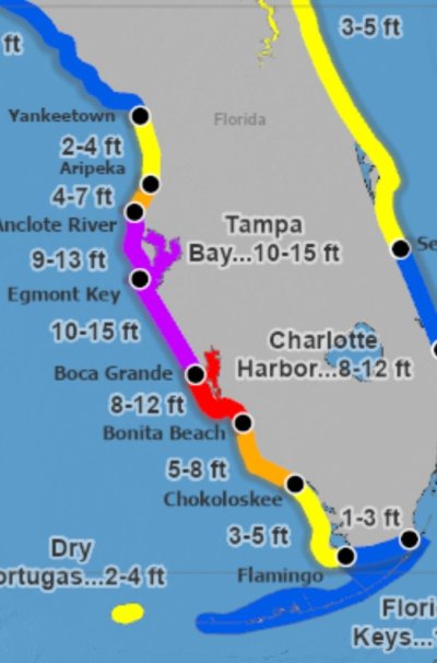
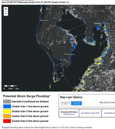
Just for kicks, we have a space for one boat on our dock if someone wants to evac Fort Myers area with their boat. No charge, only 20 amp to that slip, but it's available if anyone wants to move to a safer area for a few days until the storm passes. This particular slip is limited to 4.5' draft though.


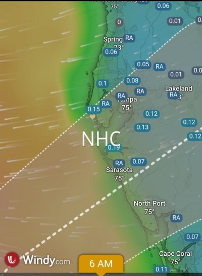
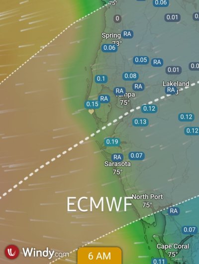
Best of luck to everyone with this one. We're just expecting a lot of rain here.
 
Boat prep is done. Batteries are topped off to 100% via generator today while I was prepping since shore power is still out. This time I secured the fridge so I am just drawing enough for the Wifi/internet, bilge and dry bilge, cameras and just a few other items. That gives me 10 days of monitoring the boat via internet from home. I installed an extra camera in the bilge. So I can monitor the aft deck area, Cabin and Bilge via camera that can pan/tilt and zoon and turn on lights. Can also remotely monitor battery and electrical.

We had 9 foot surge actual during Helene and I had about 2-3 more feet of scope remaining in my lines. Today I added four 50 foot lines to the 4 aft cleats and routed them across the dock to the pilings on the far side of the walkway. That will give additional scope for additional rise and fall but still keep the boat centered. I feel I could go to a 15 foot surge.

House is done prepping with the Lexan panels, 2 generators, plenty of fuel, lots of Ryobi and Milwaukee 18v lights and fans and about 20 batteries. 36 volt lithium golf cart with a 1500 watt inverter charged...and on and on...

We are 32 feet about sea level. So for us its just a wind issue. But we are likely staying. I am in New Port Richey as well.
 
For those in the bleachers who think you just move your boat out of harms way, consider this. Milton evolved from Storm 14 just 48-hours ago. 48-hours from now he will hit central Florida with Cat 3 winds and 10-15 foot surge (the purple zone on the attached).

Where do you go? Or do you just say to hell with it -

Peter
 

Attachments

  • Screenshot_20241007_202218_DuckDuckGo.jpg
    Screenshot_20241007_202218_DuckDuckGo.jpg
    76.7 KB · Views: 16
For those in the bleachers who think you just move your boat out of harms way, consider this. Milton evolved from Storm 14 just 48-hours ago. 48-hours from now he will hit central Florida with Cat 3 winds and 10-15 foot surge (the purple zone on the attached).

Where do you go? Or do you just say to hell with it -

Peter
The hell with it....lol. Too many other things to do that are higher priority.
 
If Milton makes landfall Wednesday evening at Tampa Bay or just north of Tampa Bay, my city of St. Petersburg will be toast.

My county, Pinellas County, is a low-lying peninsula bordered on three sides by water. It has hundreds of thousands of homes at risk of flooding. Close to half of our 961,000 county residents have been instructed to evacuate, from Tarpon Springs down to Pass-a-Grille.

All businesses in Flood Zones A, B and C have been ordered to close this morning by 7 a.m. That's half the county.

The numerous waterfront and canal neighborhoods on Tampa Bay still have enormous piles of Helene debris lining their streets. The piles contain ruined appliances (refrigerators, washer/dryers, heat pumps, etc), kitchen cabinets, carpets, couches, drywall, and endless rows of black trash bags.

If Milton hits Tampa Bay or slightly above Tampa Bay, that debris is going to be scattered far and wide, including into our canals and waterways.

And the barrier islands will be rendered unrecognizable. Thousands of families will lose their homes in the storm surge. Power will be out for weeks, in this unbearable heat.

This one is going to be a rough one.
 
I'm square in the eye of this, and just pray for some relief. Helene took the contents of my home, but the boat survived quite well.

Hope others in Tampa Bay can get through this with something to come home to.
 
I really feel for you guys. I'm hoping for the best. Hopefully the eye will go south of St. Pete and send the surge into less populated areas.
 
Tuesday morning now, landfall predicted late Wednesday night / early Thursday morning. The cone has narrowed considerably, but even now, 36 hours before landfall, it ranges across 150 miles of coastline, from just below Cedar Key to Sanibel Island.
 
Will be deciding whether to stay or leave with the afternoon updated forecast. We're far enough inland that the storm surge shouldn't be an issue. It's more about whether the track stays North of us or moves South.

Have made several trips to Tarpon Springs over the last eight years with the trawler. This is just so hard to watch, the places that you cruised through getting ready to be devastated. Have friends scattered from Fort Myers to Crystal River along the coast. This is truly heart breaking to see what's coming towards them!

For my friends along the path of Milton's destruction, please stay safe!

Ted
 
Can someone explain the discrepancy of the reported strength versus what Windy reports? I’m seeing 50+ knit winds and 20ft seas. Neither sounds accurate.
IMG_2445.jpeg
 
So we beat on, boats against the current..." Boy you have a good memory. And a 1st Ed of Farewell to Arms now. Not worth as much as you'd think though. Funny, when we bought our boat and sailed it along Long Island's north shore, I wished I had that edition of GG with me, just for literary sentimental purposes.

Coincidentally we're getting off a cruise ship in Miami at the moment. All our cat and hobie sailing excursions were canceled, bad weather and rain. We're on the other side of course (Bahamas) but glad we're heading home. See you later Milton.
Taking this reminiscence to private messaging
 
Can someone explain the discrepancy of the reported strength versus what Windy reports? I’m seeing 50+ knit winds and 20ft seas. Neither sounds accurate. View attachment 158911
Understand that the area of hurricane force winds is about 50 miles across. Not sure if Windy is able to focus that precisely. Also, the eye may have much lower winds, so Windy could be averaging the eye with hurricane force winds.

Ted
 

Question: Why reported wind speed of hurricane is much higher than value forecasted by Windy?​

Answer: Windy displays ECMWF or GFS global forecast model. Neither of them is capable to predict exact peak values.​


Windy has a decent hurricane forecast tracker (see top right corner of the menu screenshot attached). My guess is their algorithm doesn't work for extreme weather.

Right now, Milton is headed just south of Tampa Bay to the barrier islands near Sarasota. Tampa itself is at serious risk. Of note, the Euro model shows the track slightly north of GFS with a swish-shot up Tampa Bay. The area has not had a direct hit from a major hurricane since 1921.

For us, as long as the roof stays on, we can rebuild. There were a lot of lessons learned from hurricane Andrew in 1992, one of which was the importance of maintaining a structures envelope. Once the windows and doors blow out, the pressure gradient lifts the roof with a kill shot to the building.

You learn a lot of interesting stuff when living in Florida.

Peter
 

Attachments

  • Screenshot_20241008_133541_Windy.jpg
    Screenshot_20241008_133541_Windy.jpg
    107 KB · Views: 11
  • Screenshot_20241008_133552_Windy.jpg
    Screenshot_20241008_133552_Windy.jpg
    84.3 KB · Views: 10
"There were a lot of lessons learned from hurricane Andrew in 1992, one of which was the importance of maintaining a structures envelope."

Whaaat... do you mean there's a problem with stapling roof sheathing down?

I returned to my uncle's farm the day after (with my 4x4 to get down the streets) and suffice to say, have a lot of memories burnt into my memory from that event, more than any other natural disaster.
 
The NHC's 4:00 PM CDT Advisory (5:00 PM EDT) has narrowed the cone a bit, and shows the likely track edging a bit to the south of the Tampa Bay entrance. Slightly better news for Pinellas and Hillsborough Counties, but these developing movement predictions are starting to resemble Hurricane Ian, which was initially headed for Tampa but wound up crossing Pine Island Sound and brutalizing the Ft. Myers area. I am so sorry for all our friends there . . .
 
11:00 p.m. update: The storm has shifted slightly south again.
The middle of the cone is now about 35 miles south of the mouth of Tampa Bay.

Sarasota.

Of course, it's still too early to predict, with even 60% certainty, where Milton will make landfall.
But I'm starting to like our odds, Seevee and Weebles.
I hope OC has evacuated away from Ft. Myers...
yes, Tarpon Springs is actually outside the cone now and surge is predicted to be nominal or negative. I really hope this storm weakens before it hits though.
 
2am shows a bit more shift southward. Ft Myers area is at risk for significant winds and surge, though Milton is forecast to weaken a bit so wind/surge reduced as well.

Peter
 

Attachments

  • Screenshot_20241009_024547_Windy.jpg
    Screenshot_20241009_024547_Windy.jpg
    87.7 KB · Views: 5
5am writeup...now a bit north of last updates...for 2 days it has wobbled maybe 20 miles on the West coast and maybe 40 on the East Coast.

It may wobble again, it may stay a CAT4 at landfall, surge still 12+ feet for Tampa Bay. Small path tweaks may occur but forecasts for wind fields, storm surges and a few other things have stayed pretty consistent for over a day now.

Current forecast landfall is just south of Sarasota putting Tampa Bay on the "clean" side. The NHC has many forecast products, some quite traditional, some experimental. The "Peak Surge" product is a very coarse view of the surge potential and shows the entire coast along Tampa (Pinellas county) as purple - 10-15 feet of surge (Helene was red/orange). Ominous

But here's the other product that I cannot reconcile. The "Inundation Model" (black background pic attached) shows flooding in Tampa Bay greatly reduced - mostly a foot or two (blue). That's what I'd expect given it's on the clean side now. But clearly it's much different than the Peak Surge forecast.

Same difference occured during Helene. The Inundation would fluctuate but the Peak Surge model did not.

Great info from NOAA/NHC. But the more nerdy stuff is a bit beyond me.

Peter
 

Attachments

  • Screenshot_20241009_062051_DuckDuckGo.jpg
    Screenshot_20241009_062051_DuckDuckGo.jpg
    72.7 KB · Views: 7
  • Screenshot_20241009_062012_DuckDuckGo.jpg
    Screenshot_20241009_062012_DuckDuckGo.jpg
    201 KB · Views: 6
As mentioned up thread, Windy has a decent projection of the hurricane. They show the ECMWF forecast too - straight up Tampa Bay.

Weather discussions these days always migrate to model shopping with many advocating for the European model (ECMWF). Wonder which model will ring the bell this time?

Peter
 

Attachments

  • Screenshot_20241009_063236_Windy~2.jpg
    Screenshot_20241009_063236_Windy~2.jpg
    91.7 KB · Views: 1
  • Screenshot_20241009_063230_Windy~2.jpg
    Screenshot_20241009_063230_Windy~2.jpg
    89.1 KB · Views: 1
A lot of flashy graphics that often conflict.

I keep my eye on raw number predictions and current measurements to weed out or fine tune some of the graphics.

Lots of source info...but the overlaps in all may have the best clues.

Very suspect of TV sensationalism, lots of info that looks at "possible" things versus the raw numbers/probabilities the Nat. Hurricane Center is publishing.

I dont repost much, its all on the net if people want specifics.
 
Well, I’m a little relieved that it wobbled south. Thats puts our home north of the “cone”.
Tje rain total concerns me more that the wind prediction at this point. I know we've seen 10 inches and have been ok, but can we handle another 2 or 4 ? Time will tell.
 
I go by raw numbers too. At sub 910mb it's definitely a cat 5 at the moment. I have seen the media clamming everyone is going to die in a cat 5 with a central pressure of 980 mb and I have seen the mention of Cat 6 with this storm due to man made global warming.
It's still a fairly compact storm. Very difficult to get Cat 5 conditions without being compact.
Water does not stack well due to low pressures so the wider the storm at an equivalent pressure, the higher the storm surge will be. Katrina was a strong Cat 2 but enormous with a storm surge of 28' at it's highest.

Milton will be hitting some upper level wind shear that should cause it to increase in pressure but also increase in width. That is worse than a compact Cat 5 like Andrew for total $ damage to property.
Florida is so populace now that no matter where it hits it will cause a lot of $ damage.
I don't put a ton of stock into models for exact details.
 
But here's the other product that I cannot reconcile. The "Inundation Model" (black background pic attached) shows flooding in Tampa Bay greatly reduced - mostly a foot or two (blue). That's what I'd expect given it's on the clean side now. But clearly it's much different than the Peak Surge forecast.
Do we know if the inundation forecast takes timing into account? If so, it may be accounting for the peak surge coming at less than high tide as well as the height of land. If a normal high tide is 4 feet below what it takes to start flooding land and the surge is expected to peak with the tide 2 feet below a normal high, then you can absorb 6 feet of surge before things start to flood.
 
I'm not sure what raw data you mean. To my eyes, the raw data is buried incredibly deep into these models that then get overlaid with algorithms. Until recently (dawn of quantum computing), there were no computers capable of crunching the numbers fast enough to assimilate the permutations. It's serious money to fund this type of forecasting. In 2016, IBM bought weather.com for $2B essentially as a sandbox for WatsonX computing. Windy and PredictWind both have significant investments in developing algorithms to digest and process the base information (which all has its roots in NOAA data and counterparts in other parts of the world, but US created data is by far the most significant contributor/developer).

I do agree that TV commentators tend to regurgitate the easy stuff. What's missing is the analysis of why the storm will change directions (high and low pressure systems, etc.).

But the raw data is meaningless without processing.

Peter
 

Latest posts

Back
Top Bottom