paper charts

The friendliest place on the web for anyone who enjoys boating.
If you have answers, please help by responding to the unanswered posts.
Paper charts are great for overall planning, not necessarily detail such as shifting sands.

Think in line of printers vs electrical documents. Each has its advantages
 
And by the way, most NAVY ships, and all submarines, navigate by inertial guidance. Surface ships use gps and the inertial is back up. For subs, GPS won’t work when submerged but inertial guidance is more than sufficient.

Ah yup, on subs they use SINS but, subs have to poke up an antenna every now and then to verify or 'adjust' the SINS. I suspect, in time of war or lots of contact, they will forgo that schedule and just carry on until a safer time.
More than likely the sub can also navigate very carefully with bottom coutures. That is assuming that data base is up to date. IF I recall correctly, SINS was used as an input
Two US subs discovered previous unknown under sea mountains.
Lesson learned, don't trust anything. If in an unknown inland area, go slow.
Using paper charts it is possible to add notes right on the charts for future reference.
I know, based upon experince, if the chart says "spoils area' steer out of it. I bumped the bottom of my N46.
 
Last edited:
On Fintry we have (had -- Fintry is for sale) redundant systems -- a Furuno MFDBB running on 24VDC with backup batteries on the wheelhouse level and a Brix running OpenCPN on 120VAC from a genset or inverter. And I still own around 1,500 paper charts, most of them left over from our 1995-98 circumnav. I still use paper for overall planning -- laying out the SE coast of Nova Scotia, Cape Breton, and Newfoundland on the dining room table. And, I still carry large scale charts of places we will go and of places we will pass, at a scale so we can get into an unexpected port if need be.


Everything can go down, even with redundancy. If a window in the wheelhouse gets broken -- unlikely on Fintry whose glass is 3/8" - but certainly possible on most of our boats -- all of the redundant electronics will get soaked. Electronics doesn't do well with saltwater.


The Bermuda Race and other major ocean races all require paper charts:
"3.20 Charts: A boat shall have non-electronic charts that are
appropriate for the race area."


Jim
 
It's a head-scratcher. Some of the same people who say don't rely on outdated paper charts and instead rely only the latest electronics version, will also say don't rely on thrusters, learn to dock w/o them. Seems contradictory. Either embrace all the latest electronic tools available today, or stick with the old ways that you learned many years ago.
 
If the gps shuts down you can still navigate wth the digital charts, even easier than with paper. Usually the charts are stored on redundant devices. If all power goes down you won’t need navigation in any event.

If all power goes down, you might need to let someone know where you are, and a paper chart might come in handy for that, I understand your logic, and if you are in a area you are familiar with, I would imagine this would be fine... Me personally, I would always want a paper chart or two onboard.

Regarding the Navy teaching celestial (which I doubt) I can elate that about ten years ago I was asked to give a lecture at the Naval Observatory in DC. When there, my host asked if there was anything they could do for me. I asked if they could get me a sextant which I assumed they had many of. After asking all his colleagues he came back to tell me that no one knew of the existence of a sextant in that institute. Amazing!!

And by the way, most NAVY ships, and all submarines, navigate by inertial guidance. Surface ships use gps and the inertial is back up. For subs, GPS won’t work when submerged but inertial guidance is more than sufficient.

I have heard similar things... However, I can state that we were DRILLED in celestial navigation during my tenure in the service, 1992 - 2012. This included LAN, sunlines, moonlines, determining gyro error against Polaris, horizontal sextant angles for visual navigation, ad infinitum. We had a GPS (WRN-6, with crypto) interfaced with a WSN (Inertial Navigation System), and on my first and second ship, we even had NAVSAT, the precursor to GPS (doppler based) interfaced to a WSN-5.

I even wrote BASIC programs on my Casio calculator to handle sight reduction!

It was an incredible time to serve and apparently the end of an era... We were forced to source a diverse range of information sources for position derival, to include radio navigation, radar, sonar, GPS, NAVSAT, and visual aids. I have spent many, many hours hunkered over a chart, dropping LOP's. Voyage planning was an entirely different manner, and we did not have the tools available now.

We did have a tool, called JOTS, which was a graphical display of the ship's position, the charts were vector and not very detailed, and the navigation team did not have access to any displays as they were in CIC (Combat Information Center).

Thanks for bringing back some great memories, I had the best office in the world, the bridge of a ship, with the best view, and the coolest job in the United States Navy, shipboard navigation!!!
 
Ah yup, on subs the use SINS but, subs have to up an antenna every now and then to verify or 'adjust' the SINS. I suspect, in time of war or lots of contact, they will forgo that schedule and just carry on until a safer time.
More than likely the sub can also navigate very carefully with bottom coutures. That is assuming that data base is up to date.
Two US subs discovered previous unknown under sea mountains.
Lesson learned, don't trust anything. If in an unknown inland area, go slow.
Using paper charts it is possible to add notes for future reference.

The subs did have OMEGA (we even had it aboard ship), as I recall fix accuracy was +/- 2 nautical miles...

EDIT: I assume OMEGA is what you are referring to...
 
Last edited:
It's a head-scratcher. Some of the same people who say don't rely on outdated paper charts and instead rely only the latest electronics version, will also say don't rely on thrusters, learn to dock w/o them. Seems contradictory. Either embrace all the latest electronic tools available today, or stick with the old ways that you learned many years ago.

Maybe picking and chosing is because of what lots of experience teaches you....not internet forums and magazine articles and race committees that have to reduce to the lowest common denominator.
 
The IMO is a UN body governing international commercial shipping, not recreational boating. I realize that many trends as in changing technology tricked down to us but I find that very unfortunate as I, too, still want paper charts back up. Just like I want a sextant available for celestial navigation when I’m offshore. Electronics can and do fail. I have started with 3 GPS’s onboard for a delivery from Hawaii to the mainland and arrived SF with none working for various reasons.
 
Paper charts

We have been cruising for over 3 years,on our selene 53 previous owner had installed several redundant systems for navigation and radar all systems are stand alone he must have spent thousands on the systems all touch screen. However unless you download avionics on a very regular and expensive basis. The electronic maps are ok at best now if they are upgraded and you stay on it then the definition is awesome but paper charts from Noah and years of chart upgrades by the us navy give you charts that are hard to beat understandably bulkier and looking at charts at night are a pain but they are great backup also we recently went through the canal and at inspection they asked if we had paper charts for where we were heading and we did. So paper seems old school but a good idea and you can make a nice table covering. Captain jerry out
 
It's easier to plan using paper charts because you can see the big picture, not just a small section from the electronic charts. I also like to follow our track using the paper chart in case the electronics fail. We have 2 Garmin chartplotters and an iPad Pro running Navionics and Aqua Map. We also have an AIS transceiver and an inReach tracker so our family and friends can follow our progress.
 
I still carry charts. I have my electronic's stand alone as well. ( I have 4 GPS systems running). I also carry a sextant, handbearing compass. The main reason is security. If the electronics die, no problem for me. I have been on a boat in the ocean where we've had fire and electrics destroyed. Picked up the sextant, with a few hours of sun-runs and median passage, a good plot is running. Picked up a lot of silverware in one ocean race after one battery fire. Even in a well maintained vessel things can go wrong. Ask the US Navy. One supposes if you stay inshore then you could rely on electronics, or call the coastguard if you get lost. However if seriously offshore even the worst , oldest out of date chart has a use. I might add the sextant gets pulled out regularly as done the Sestral hand bearing compass.
 
Last edited:
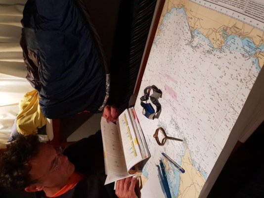
On a journey crossing the English Channel, the paper charts, the book of tides and currents and a backup tablet in case the wind blows your chart away.
 

Attachments

  • 20181019_225822.jpg
    20181019_225822.jpg
    141.5 KB · Views: 33
  • 20181017_183236.jpg
    20181017_183236.jpg
    148.8 KB · Views: 40
The subs did have OMEGA (we even had it aboard ship), as I recall fix accuracy was +/- 2 nautical miles...

EDIT: I assume OMEGA is what you are referring to...

I am not familiar with OMEGA. I think that is 2 different system.
I was main propulsion. I would wander into the command area when off watch... Even got to look through the scope once. Anything poke to the surface would attract the gulls.
 
Sextant ...... I have one and still hoping I can find a course.
 
Omega was a land based system from the 60-70's I thing it was developed from the DECCA system from the WW2 aftermath.

Then we had Loran "A" (Worked well with limited range)

Then loran "C" (longer range system, was'nt impressed with it)

Then we moved on to Sat-Nav.

From that they developed the current GPS systems
 
I am not familiar with OMEGA. I think that is 2 different system.
I was main propulsion. I would wander into the command area when off watch... Even got to look through the scope once. Anything poke to the surface would attract the gulls.

OMEGA was a unique system, used signals in the VLF (Very Low Frequency) range, I knew of one transmitter in the Pacific Northwest, many others I am not aware of. The signal could be received UNDERWATER...

We had a LORAN-C unit which I don't ever recall having used...

There was a European system called DECCA which I am unfamiliar with...
 
Paper charts and future reliability of gps

I am not sure of the specific citations (could research it if necessary), but for the following reasons, please keep your paper charts and know how to use them to chart courses, estimate tidal or wind offsets, calculate distances, etc.

1. It is now well known that the Russians recently blew up one of their own satellites and the debris field forced the International Space Station (ISS) multinational crew to temporarily get into the escape module because of debris possibly hitting the ISS. If they (or other nations like China) can do that to their own satellites, they can do it to ours (or other GPS satellites).

2. The Federal Communications Commission (FCC) has recently leased band width in the same frequencies as our GPS satellites to a non-GPS commercial entity. Other governmental agencies and users like UPS, FedEx, police and fire departments, and ambulance providers all objected to the leasing because of possible degradation of the GPS signals. The FCC went ahead. The future reliability and accuracy of GPS may be in jeopardy.

Save your paper charts!
 
At the moment I have a chart book. I am considering purchase big charts for the east coast again. Seems all my charts either disappeared or went with the N46. SHRUG
current I am having the almost newest nav system,
Garmin 18 XHD, 2 screen so I can keep radar on screen. Both screens can show all the data.
Don't ask me about it. It is still being installed. Comes with a fancy multi color radar with AIS and the other screen all the usual NAV stuff plus everything else.
Really, it has too much stuff for me to learn. Electronic charts, radar, depth sounder. Everything else ..... I will let the next owner worry about it. LOL
 
Last edited:
I have found that close quarters cruising at night should be avoided. The best was I have found to do this with both paper and electronic ones is “Google Earth.” I first lay out my intended route on OpenCPN with C-Map World which I have on my home desktop computer, my Dell Laptop and my Samsung Tablet. I can do this on the desktop and transfer the data to either or both of the others for use on the boat. Then I set out the same route on Google Earth.
Potential hazards may be more easily revealed on Google Earth than on charts. Example: A few years ago a Rolex Round the World racing yacht hit a shoal in the middle of the Indian Ocean while racing to the finish line of their leg. The obstacle was very obscure or nonexistent on their electronic navigation but clear as a bell on google Earth. I zoomed in on this obstacle on Google Earth down nearly to sea level and then zoomed out 4,000 miles in space. The shoal was still visible from that altitude.
So after establishing all the legs of a voyage on both the electronic navigations and Google Earth I can decide where on the route I might need to shift some of the legs to stand out to sea further to provide safe clearance.

 
remember sailing back and forth from Bermuda to the US and Caribean when gps first came out , greates thing sliced bread until we got struck by lighting. everything fried just glad i had my paper charts and sexton.
 
It's easier to plan using paper charts because you can see the big picture, not just a small section from the electronic charts. I also like to follow our track using the paper chart in case the electronics fail. We have 2 Garmin chartplotters and an iPad Pro running Navionics and Aqua Map. We also have an AIS transceiver and an inReach tracker so our family and friends can follow our progress.
When you say paper charts let you see the big picture, what scale chart are you using. With a chartplotter the restriction is screen size compared to the paper chart size. What if you had a screen the same size as the paper chart, would it still be better with paper?

For instance on a 4x3 foot (approx) chart CHS3001 I can see all of Vancouver Island, the outside offshore and all the inside passages. Within that chart there are 100+ various larger scale 4x3 foot charts
 

From your link, a trawler has about a 1.5 in 1000 chance of a lightening strike (I understated that at 1 in 1000). A sailboat 3.8 in 1000.

Regarding old charts, if I decide to go to Pitcairn Island, I dont want the Admiralty charts that the Royal Navy at the time had, but the electronic ones that get upgraded every week or so.

This sort of thinking is like using a digital meter instead of an analog one, thinking it is more accurate because the display has the air of certainty. Do you really, really think that the electronic charts of Pitcairn are updated with newly acquired information every week? I'll bet a beer that the information on your electronic chart came directly from 19th century Admiralty charts and has been updated little or none since then.
 
Out of curiosity, how old are your paper charts?

I use my paper charts that are updated annually in a large scale to get a broad overview of the daily course, and TMGOG on hourly check points.

For the fine details I use my two Furuno TZTBB plotters in split screen mode to get the details such ad buoys and channels and waypoints. Then draw in a final plot with all of the details. Being off 20' to the side can leave you high and dry. I use 1/4 screen in hi-way mode for steering to course.

That way I have paper, two electronic plotters on the dedicated pilot house batteries, and three GPSs, I have an iPad for what good it is. :blush:
 
Last edited:
From your link, a trawler has about a 1.5 in 1000 chance of a lightening strike (I understated that at 1 in 1000). A sailboat 3.8 in 1000.


This sort of thinking is like using a digital meter instead of an analog one, thinking it is more accurate because the display has the air of certainty. Do you really, really think that the electronic charts of Pitcairn are updated with newly acquired information every week? I'll bet a beer that the information on your electronic chart came directly from 19th century Admiralty charts and has been updated little or none since then.

The link also discusses the chances of getting hit being 3 times greater on a larger boat versus smaller boat. Also east coast boats 10X more likely to be hit. Look at the bigger picture.
 
"Sextant ...... I have one and still hoping I can find a course.

Celestial Navigation for Yachtsmen,,by Mary Blewitt

This book will teach you how to navigate the sextant. You will also need a good timepiece.

If you want a good laugh , read Bowditch after Mary B., to see how confusing the subject can get.
 
Last edited:
This discussion reminds me of an enlightening discussion during a boat delivery I crewed on.
My brother (the selling broker) asked me to crew for a boat he was helping the new owner deliver from Chesapeake to LI Sound. Owner told us all about his years of experience. Blah, blah, blah. My brother & I planned routes and timing based on tides. While underway we were discussing present course/ heading and the question came up whether the course mentioned was "true" or "magnetic"? Owner admitted he didn't know what we were talking about? Compass points were due to magnetic field of the earth so magnetic?
When asked if he ever inspected the compass rose on a chart he again admitted he didn't use charts just pointed to a waypoint on the screen... navigating is simple! Apparently he had been sailing for years without a clue that there was any difference between true and magnetic likely because he never saw a compass rose on a screen and never thought he needed to "learn" how to navigate... its simple point to a spot on the screen and just "go" there.
I'm pretty sure he never got the message eventhough the situation was a wake up call.... he didn't take the call!
Studying a paper chart, the foot notes, compass rose, etc can be educational in and of itself.
 
Commercial pilots no longer haul around paper charts. Seems falling out of the sky or crashing into land when going .76-.90 mach would be more reason for paper backup when electronics fail and yet they stopped carrying paper charts at least five years ago.
 
If a plane failed to the point it is falling out of the sky, not sure how much navigation charts would help. Same as if China suddenly shoots down our gps satellites. At that point I think you have bigger problems than getting to your next anchorage.
 
Thang Kew to all who participated in this discussion.

What we've realized from this thread is that there is hardly any reason not to have a paper chart or two and not really any absolute reason to carry them either. All the electronics available are usually more up to date and we're not really concerned with the "what if" for electronic total failure. If we were worried about the "what if" then we'd have to take duplicate drinking water filters, duplicate freezers, duplicate engines, duplicate .... ad infinitum.

That said, we do realize that a paper chart can provide a better overview of the area and a pencil can make notes and arrows when desired. Lately we've become a little frustrated with automobile nav in our truck and have resorted to paper maps for some refreshing route planning.

Perhaps our most compelling reason to have paper charts is that we can share planning, current navigation, and a history of where we've been with family and friends. It is nice to involve others with such enjoyable experiences as plotting a course and using parallel rules and a compass on the saloon (salon?) table.

So, wife says she enjoys a map as do I. We will carry a map but rely on most critical up to date information by using electronics.

Again, thangs again to all who have been a part of this thread.
 
Back
Top Bottom